News in 2024

|
Introducing the China-Africa Geospatial Information Cooperation in the
Low-Altitude Economy
September 2024
Kabir, M.M, and Stephen Djaba visit to several geospatial
information cooperation summits and workshops on low-altitude economy in
China
By Kabir, M. M (FIG-ARN), Stephen Djaba (LiSAG), Hans Ni (Beijing
iSpatial)
As the 9th High-Level meeting of the Forum of China-Africa
Cooperation (FOCAC) between the President of China and heads of African
States and governments was going on from 4-6 September 2026 in Beijing,
China, another important chapter for cooperation between China and
Africa was being opened in geospatial industry, that is the China-Africa
Geospatial Information Cooperation in the low altitude economy.
The Initiative was driven by Kabir, M. M, the Chairperson of
FIG-Africa Regional Network (FIG-ARN); Hans Ni, the Secretary-General of
Working Committee on International Exchange and Cooperation, China
Association of Geospatial Industry and Sciences; and Stephen Djaba Vice-
President of the Licensed Surveyors Association of Ghana (LiSAG).
Low-altitude economy refers to an emerging economic sector that
leverages various low-altitude flight activities from manned and
unmanned vehicles below 3,000 meters in airspace. The industrial chain
of the low-altitude economy includes upstream manufacturing, midstream
operations, and downstream applications. Low altitude economy is gaining
momentum especially in areas of surveying and mapping, agriculture,
tourism, logistics, environmental management, and emergency response. It
promises to become the new pathway to achieving sustainable development
at community, regional, and global levels.
Recognizing these developments and the endless opportunities in the
sector, the Chinese government has integrated low-altitude economy as a
national priority in governance and institutional work report. Year 2024
has therefore been named the first year of the low-altitude economy by
the China industrial sector
From 1 - 8 September 2024 as a follow up to 1st China-Africa
Geospatial Information Conference, Hans Ni, who is also the CEO of
Beijing iSpatial Co., Ltd, FIG corporate member, invited the Kabir, M.M,
and Stephen Djaba among other international key stakeholders to
participate in several geospatial information cooperation summits and
workshops on low-altitude economy. Highlights of the main activities
included
1). The UAV Fair in Yiwu and International Cooperation Forum
From 1 to 3 September 2024, the FIG-African team attended a UAV Trade
Fair at the Yiwu International Expo Center, Yiwu, central Zhejiang
Province. The Fair was organized by the Remote Sensing Branch of the
China Association of Remote Sensing Application. Central to the Fair was
the "1+5+N" model that focuses on the management, production, learning,
research, business, and use of UAVs in five thematic areas principally
the digital economy, international trade, emergency rescue and safety
development, aerostat technology, and low-altitude logistics.
The session on International Geospatial Cooperation Forum (IGCF) was
anchored by Hans Ni. The forum explored areas of cooperation in Low
Altitude Economy and Management of Smart City; Africa-China Geospatial
Industry Cooperation and Barter Platform; South-South Cooperation in
Remote Sensing Research and Education, and ways of fostering
international collaboration in digital economy for a shared future. The
Forum attracted more than 40 scholars, entrepreneurs and business
representatives from 30 countries, including China, Germany, France,
Spain, India, Colombia, Nigeria, Ghana and Egypt.

Figure 1: Kabir, M.M gave a keynote address and introduced the FIG
and the Africa Regional Network
The delegates were inspired by the rapid transformation of Yiwu. The
city leapfrogged from a small town to an international trading city and
key to the Belt and Road Initiative by adopting innovation and
geospatial industry. In the first half of the year 2024 alone, the total
import and export value of Yiwu reached 324.77 billion yuan or around 45
billion USD, involving 2.1 million kinds of commodities.
2). China-Africa Geospatial Information Cooperation (CAGIC) Seminar
The China-Africa Geospatial Information Cooperation seminar took
place from 4-5 September 2024 at Deqing Geospatial Information Town. The
session was hosted by Deqing Association for Geospatial Professionals
and it centered on fostering cooperation between China and African
countries in areas of capacity development, establishment of protocols
for VR stimulated trainings, exchange program, internship, and opening
of liaison offices at the World Geospatial Information Home (WGIH) in
Deqing in order to strengthen collaboration and sharing of geospatial
knowledge and industry between China and Africa
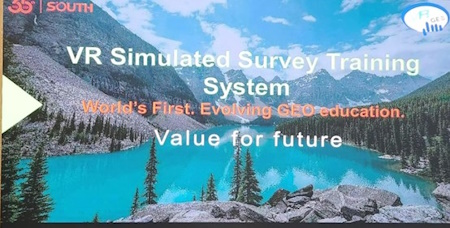
Figure 2: Session delivered by South Inc. on Evolving GEO education
Through Virtual Reality Simulated System
The seminar was attended by more than 80 professional participants
across the globe. Kabir, M. M and Stephen Djaba delivered keynote
speeches about current situations and developments of geospatial
information in Nigeria and Ghana respectively.
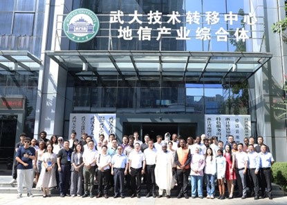
Figure 3: A Group Photograph of a Section of Participants at the
CAGIC Seminar
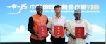
The CAGIC seminar was concluded by signing of Memoranda of
Understanding on promoting cooperation in the relevant geospatial
information fields between China and Africa by Hans Ni, Kabir, M. M, and
Stephen.

Figure 4: L-R Stephen, Hans, and Kabir exchanging the Protocols of
CAGIC
3). Working Visits to Key Geospatial Industries and Centers in China
Strategic to laying a solid foundation for the implementation of the
CAGIC, Hans Ni organized several interfaces and working visits to some
relevant geospatial industries and centers in various regions of China
by the African team. These included
a). Working Visits to UAV manufacturing companies, Aviation Towns
and Robotics Centers in China.
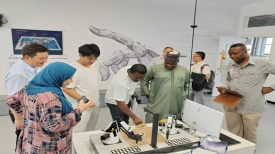
Figure 5: A Photos During One of the Working Visits
b). Working Visit to the Geographic Information Science and
Technology (GIST) Museum, Deqing,
Deqing hosted the first UN World Geospatial Information Congress in
2018 and is where the UN-GGKIC is located. At the museum the team were
apprised on the historical developments of GIS in China and the current
status and future global trends
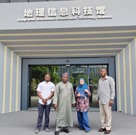
Figure 6: Geographic Information Science and Technology Museum,
Deqing, China
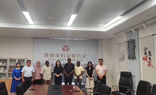
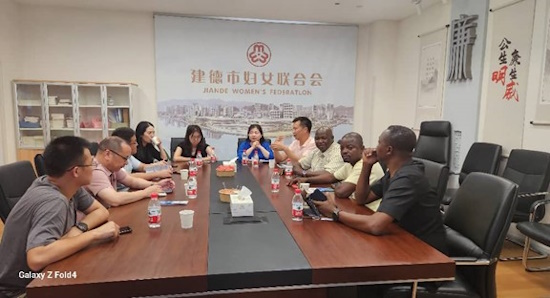
c) Working Visit to the Jiande Women’s Federation, Zhejiang Province
The team also conducted a working visit to the Jiande Women’s
Federation with the view of gaining new perspectives from China’s
Reforms that promoted the rights, equality, visibility, and roles of
women in societal development without forgetting the old family values.
The visit provided the team new insights and opened areas of possible
cooperation between African Women Land Professional Associations and the
All-China Women’s Federation.
Figures 7&8 Photos of a Meeting Session with Representatives of
Jiande Women's Federation, China
d). Special Working Visit by Kabir, M. M to the International
Research Center of Big Data for Sustainable Development Goals (CBAS)
Mr. Kabir, M. M was granted a special visitor status to the
International Research Center of Big Data for Sustainable Development
Goals (CBAS) where he discussed the challenges and prospects of
implementation of SDGs in Africa. New areas of collaboration in capacity
building and information sharing between African professionals and the
CBAS were outlined and discussed. Kabir, M.M accompanied by Surv. Adamu
Bala, YSN and PhD student in China, also visited other centers and
organizations within the CBAS premises. Fruitful discussions were held
in areas of collaboration on capacity building, e-learning, summer
school, and supporting geospatial industry start-ups in Africa. The
centers included
- The UNESCO International Center on Space Technologies for
Natural and Cultural Heritage
- Aerospace Information Research Institute (AIR), Chinese Academy
of Science;
- Office of the Integrated Research on Disaster Risk; (IRDR) and
- Silk Road Economic Belt (SREB) office among others
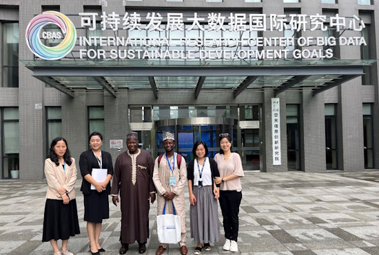
Figure 9: Special Working Visit Organized for Kabir, M.M to the
International Research Center of Big Data for Sustainable Development
Goals (CBAS) and Other Agencies in Beijing.
Mr. Kabir, M. M
September 2024