United Nations Sponsors Permanent Committee on GIS
Infrastructure for Asia and the Pacific (PCGIAP) Ad hoc Meeting
27 October 2011, KINTEX, Ilsan, Republic of Korea
|
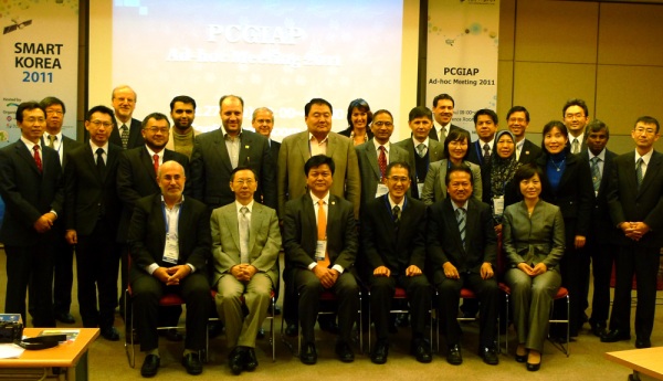
Dr.
LI Pengde, President [3rd L-R], Dr. Hiroshi Murukawa,
Vice President [4th L-R] and Mr LEEM Seong-an, Secretary [2nd
L-R] together with National Delegates and observers at the PCGIAP Ad
hoc Meeting, 27th October 2011 |
PCGIAP convened an Ad hoc meeting on the sideline of the United Nations
1st High Level Forum on Global Geospatial Information Management and the
meeting was attended by 13 of the 56 member jurisdictions.
The meeting not only considered administrative matters and reports, but
reviewed ongoing activities undertaken by its Working Groups. More
importantly, on the heels of the successful inaugural United Nations High
Level Forum on Global Geospatial Information Management, the meeting
discussed common issues and challenges within the region as well as the
future direction of PCGIAP. There were consensus to have PCGIAP renamed to
UN-GGIM Asia and the Pacific, to consider policy and institutional related
challenges and to collaborate with international geospatial information
societies such as FIG on technical and capacity related challenges.
The challenges of small island developing states in the Pacific in
participating in PCGIAP’s meeting and activities was highlighted and FIG
expressed its desire to collaborate with PCGIAP in particularly to further
the intent and objects of the FIG “Sydney Agenda for Action”. FIG and the
Task Force on Surveyors and Climate Change should begin a dialogue with her
member associations in Australia and New Zealand to consider avenues to
further the intent and objects of the FIG “Sydney Agenda for Action”. This
also has to be taken into consideration the light of the United Nations
Conference on Sustainable Development (Rio+20) in Rio de Janeiro, Brazil
between 4 – 6 June 2012.
The meeting also welcomed the support and collaboration of FIG and its
sister organizations within the Joint Board of Geospatial Information
Societies, namely GSDI, ICA and ISPRS in this instance, in the upcoming
International Symposium on Spatially Enabled Government and Society with the
theme “Towards Spatial Maturity” that will be organised by the Department of
Survey and Mapping Malaysia in Kuala Lumpur, Malaysia between 15 & 16
February, 2012. The outline program was discussed and endorsed at the
meeting and members present expressed both enthusiasm and intention to
participate in this important symposium, essentially the first response from
the Asia and the Pacific Region following the highly successful United
Nations inaugural High Level Forum on Global Geospatial Information
Management. The Symposium will have the following four sub-themes –
Spatial Enablement: Legislative and Governance Framework;
Spatial Enablement: Positioning and Information Infrastructure;
Spatial Enablement: Contribution of Geospatial Professionals and Industry;
and
Spatial Enablement in Action and Towards Spatial Maturity.
In addition, it was proposed that there will be a forum on Malaysia’s
User Driven Approaches, bring the user’s dimension into the consideration of
the symposium as well as a Panel Discussion on “Spatial Maturity: Dream or
Reality”.
CheeHai TEO
President
October 2011
|

Sydney Agenda for Action |
11 November 2011
|