Article of the Month -
October 2009
|
Spatial Planning and Climate Change
Adaption in Coastal Regions: The Case of Vietnam
Dr. Isaac BOATENG, Senior Lecture, University of Portsmouth, United
Kingdom

 This article in .pdf-format (17
pages and 2.5 MB)
This article in .pdf-format (17
pages and 2.5 MB)
1) This paper has been prepared for presentation
at the 7th FIG Regional Conference in Hanoi, Vietnam, 19-22 October 2009
and offers an interesting view to one of the key themes of the
conference.
Keywords: Spatial Planning, Climate Change, Coastal
adaptation, Coastal zone of Vietnam
SUMMARY
Spatial planning in coastal regions has emerged as a major issue in
the 21st century due to the potential impacts of the changing climate
and the associated rising sea levels in coastal regions. This paper
explores the potential impacts of climate change and the vulnerability
of the coast of Vietnam based upon geodetic information and the present
coastal development. It then discusses how sustainable spatial planning
approaches could be used to reduce vulnerability to climate change and
ensure sustainable coastal adaptation of Vietnam’s coastal zone. Based
on a large-scale flood risk assessment, the study identified that
non-structural approach could be used by Vietnam to adapt her low-lying
coastline in the North and the South to climate change as this strategy
enables vulnerable areas to be occupied for longer before eventual
retreat. However, structural adaption policies could be pursued at the
central coast which has high elevation and relatively hard geology. The
paper revealed that sustainable and successful adaptation to climate
change could be achieved if it is perceived as a process similar to
spatial planning. It should be planed, implemented well in advance,
monitored and evaluated before the occurrence of a natural disaster or
an environmental change. Based on this, it recommended that Vietnam
should develop and implement coastal adaptation policies now in order to
forestalled huge impacts of future climate related disasters. The paper
concludes that though coastal adaptation to climate change is a new
phenomenon, it does apply key principles of spatial planning concepts
and therefore recommended that spatial planning principles should be
adopted for the development and implementation of sustainable coastal
adaption policies to reduce the impacts of climate change.
1. INTRODUCTION
Vietnam is located between longitude 102º 09′ and 109º 30′ East, and
latitude 8º 10′ and 23º 24′ North. The country is bordered to the North
by China, to the West by Laos and to the South west by Cambodia. The
Eastern side of Vietnam is bordered by 3,260km meandering coastline
which stretches from Mong Cai in the North to Ha Tien in the South. The
coastline is dissected by two major river deltas (Red River in the North
and Mekong River in the South) and many streams at the central area
(Figure 1).
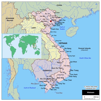
Figure 1. Location of Vietnam
The country is divided into 8 administrative regions and 64 provinces
(Figure 2). The coast of Vietnam can be divided into 3 cardinal areas:
North coast, Central coast and the South coast. The coastal zone
comprises 28 provinces out of the 64 provinces in the entire country and
it is a home to nearly 50% of the national population (Figure 7) (Hanh
and Furukawa, 2007).
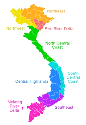
Figure 2. Administrative regions in Vietnam
Source: www.especen.vn
The country is influenced by two (South-westerly and North-easterly)
tropical monsoon climatic regimes and mostly affected by natural
disasters associated with these two climatic regimes which include storm
surges, monsoon rains, flooding, typhoon and El-Nino conditions. Vietnam
has suffered numerous cyclones/typhoons, storm surges and floods, with
significant human, economic, and social damage to the country (Imamura
and To, 1997).
In spite of the diverse measures including construction of coastal
dikes, improved river channels, forecasting and early warning systems to
control floods, Vietnam still continues to experience significant damage
from floods and typhoons. Hanh and Furukawa (2007); Imamura and To
(1997) identified rapid population growth, increasing preoccupation
around hazardous areas and insufficient financial support to construct
and maintain the dikes and river channels as some of the causes of the
coastal problem. However, the vulnerability of the coastal zone of
Vietnam could be attributed to low coastal elevation, climate change and
associated sea level rise. Much of Vietnam’s coastline, especially areas
around the two deltas in the north and south and the numerous inlets
along the central coast has elevation below 1m. Unfortunately these
low-lying coastal areas are largely developed and serve as economic
centres of the country. These physical characteristics and the land-use
of the coastline make large areas of the coastline more vulnerable to
climate change and associated sea level rise.
Tuong (2001) identified a sea level rise between 1.75 and 2.56
mm/year at 4 Vietnamese stations (Hon Dau, Da Nang, Qui Nhon, Vung Tau).
The high value is observed in the northern and in the southern parts of
the country. Another study conducted by Hanh and Furukawa (2007)
identified a similar trend and came to a conclusion that there is enough
evidence to support the fact that sea level rise is occurring in
Vietnam. They observed that the rate of sea level rise in Vietnam is
comparable with the sea level rise in the region and in the world. Now
two questions that need to be answered are what impacts will the rising
sea level have on the coastal zone of Vietnam? And what adaptation
strategies should be developed to manage the potential deleterious
effects of climate change and associated sea level rise? The aim of this
paper is to provide answers to these questions.
2. METHODOLOGY
In order to do effective and reliable assessments of climate change
impacts on the coastal zone of Vietnam and to recommend practical
adaptation policies, relevant literature on climate change impact
assessment and adaptation was reviewed. It was identified from the
literature review that many scientific methodologies that have been
developed by researchers for the assessment and management of the
impacts of climate change are covered in Intergovernmental Panel on
Climate Change (IPCC) periodic global assessment report on the impacts
of climate change on the sustainability of the world environment and
global economy ( IPCC, 2001and 2007). Apart from those methodologies
covered in IPCC reports, there are numerous climate change assessment
approaches and management policies that have been developed by national
environmental agencies and local researchers. Example of these national
and local approaches includes UK’s, Department for Environment Food and
Rural Affairs (DEFRA) (2009) climate change adaptation report;
International Centre for Environmental Management (ICEM) (2003)
assessment report on Vietnam’s protected areas and development;
Australian Department of the Environment and Heritage, 2006 assessment
of vulnerability of the Australia’s coastal zone and Stern (2006) review
on the economics of climate change. Table 1 below provides a summary of
key climate change adaptation policies identified in the literature
review.
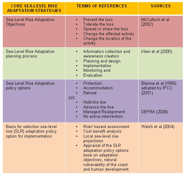
Table 1 Summary of the Review of Sea-level rise Adaptation
Policies
Source: Boateng, (2008)
Following the literature review, vulnerability of the coastal zone of
Vietnam was assessed. Geo-reference Shuttle Radar Topography Mission
(SRTM) data of Vietnam, which is a satellite image with ground elevation
was obtained from the University of Maryland, USA and was used to assess
the flood risk along the coast of Vietnam based on predicted future sea
levels and potential storm levels. The data was rectified and opened in
ERDA Imagine, Virtual GIS image interpretation software and three
different flood layers were created on the image. They are:
- One metre, (predicted sea-level rise by 2100; IPCC,
2007),
- Two meters (the latest upper limit prediction for
sea-level rise by 2100; Pfeffer, et al, 2008), and
- Five metres (worst case scenario involving catastrophic
melting of west Antarctic ice sheet; Vaughan, 2008). The results of
this assessment are presented as the flood risk maps of Vietnam in
Figures 3-6.
This was followed by analysis and discussion of vulnerability and
potential impacts of sea level rise on the coastal zone of Vietnam and
the assessment of possible adaptation policy options to manage/address
the risks identified from the flood risk maps. This approach facilitated
the assessment of alternate adaptation policies and the selection of the
best policy option base upon the local circumstances/vulnerability and
environmental sustainability.
3. IMPACTS OF CLIMATE CHANGE ON THE COAST OF VIETNAM
The flood risk assessment result (Figure 3) revealed that a
significant proportion of the coastal zone of Vietnam is under severe
threat of flooding. The assessment shows that the Red River delta in the
north (Figure 4) and the Mekong River delta in the south (Figure 5) are
the highest risk areas. Unfortunately, these two areas are the most
fertile, productive and highly developed regions of the country where
the capital town, Hanoi and the second town Ho Chi Minh City are located
(Figure 7 and 8). It was identified that though the central coastline
(Figure 6) has low flood risk, settlements and agricultural activities
at the numerous inlets and estuaries are largely vulnerable.
It is important to state that the sea level rise assessment in this
paper did not consider possible subsidence or uplift (tectonic forces)
of the coastline. Holding land movement constant, the flood risk
assessment considered the potential impacts of climate induced sea level
rise. IPCC, 2007 identified that the severe impact that may be
associated with climate induced sea level rise would be influenced not
only by the rising waters but also the increased intensity of climatic
forces such as increased waves and tidal activities, storm surges,
typhoons, increased rainfalls, increase monsoon winds and flash floods.
Increased intensity of these climatic forces coupled with the rising sea
level could have deleterious impacts along the coast of Vietnam,
particularly, the two deltas (Figure 4 and 5).
Possible impacts of climate change and associated rise in sea level
identified in Vietnam based on the flood risk assessment could be
outlined as following:
- Inundation of the deltas of Red and Mekong Rivers, low-lying
coastal areas (Inlets and estuaries) and the intervening fertile
agricultural lands.
- Destruction of coastal settlements in the flood risk areas
(Figure 3) will cause displacement many coastal dwellers and
possibly result in coastal hinterland migration. If this is not
managed properly it could lead to land litigations and ethnic
conflict.
- Increased coastal erosion and landslide especially, around the
deltas and the cliffs along the central coast.
- Increase flooding and natural disaster may lead to increase loss
of life and livelihood associated with natural disasters.
- It may lead to significant loss of farmlands, wetlands, mangrove
and cause coastal squeezes.
- It will cause intrusion of salt water into freshwaters and also
increase water borne diseases.
- It will significantly reduce rice production in the country and
reduce food security of the country and other countries that import
rice from Vietnam.
These impacts, if not properly managed through holistic and reliable
climate change adaption policies planned in advance, they could have
serious ramifications on the economic development of the country.
Vietnam’s economy like many developing countries, is highly supported by
agricultural production and heavily dependent on natural resources.
Therefore, any natural or artificial phenomena that affect the
prevailing natural environmental conditions is likely have serious
effects on sustainable economic development and the livelihood of many
Vietnamese if not well managed.

Figure 3: The Flood risk map of Vietnam
Figure 4: Flood risk map of the North coast of Vietnam
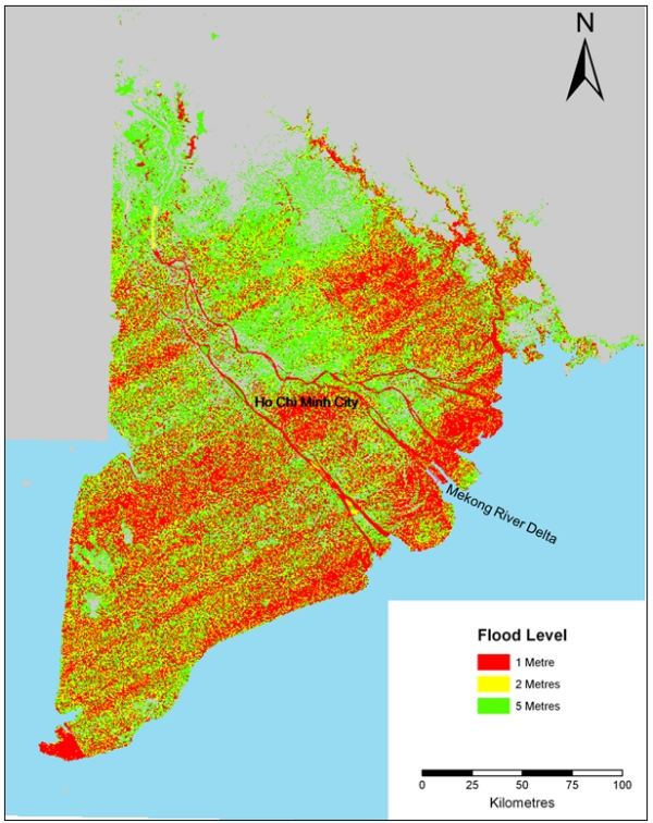
Figure 5. Flood risk map of the South coast of Vietnam
Figure 6. Flood risk map of the
central coast of Vietnam
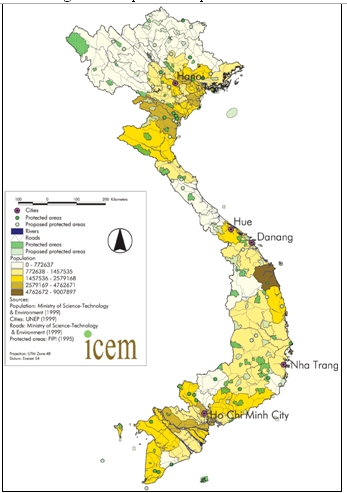
Figure 7. Population map of Vietnam
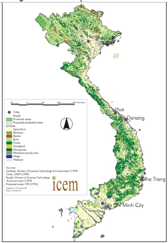
Figure 8. Land use Map of Vietnam
4. COASTAL ADAPTATION AND SPATIAL PLANNING
The huge physical and socio-economic impacts of sea level rise on the
coastal zone of Vietnam required serious research effort and policy
development towards integrated and sustainable coastal adaptation
strategies for the coastline. Tol et al, 2008 revealed that to identify
the most appropriate coastal adaptation strategy, we must consider the
full context in which the impacts of climate change arise and realise
that the aforementioned strategies (Table 1) happen within a broader
policy process, which includes consideration of numerous climate and
non-climate issues.
Klein et al (2000) observed that adaptation to climate change in
coastal zones should be viewed as a process that comprises more than
merely the implementation of technologies to protect against, retreat
from, or accommodate sea level rise. Tol et al, 2008 identified from
studies in the Netherlands, the United Kingdom, and Japan that coastal
adaptation to climate change can be considered as a multistage and
iterative process. In each of these countries, management approaches
have been adjusted over the past decades to reflect new insights and
priorities, including concerns about climate variability and, more
recently, climate change. This reflects sea level rise adaptation
planning process outlined by Klein, 2000 (Table 1).
The concept of multistage and iterative process for coastal
adaptation to climate change (Tol et al, 2008) mirrored key principles
in spatial planning. By this approach adaptation measures are planned
and designed well in advance to reduce the vulnerability of coastal
communities or ecosystems to the impacts of climate change. This is done
as a process that is conditioned by policy criteria and coastal
development objectives and interacts with existing management practices.
It also involves monitoring and evaluation of the performance of the
implemented adaptation options which may lead to the provision of new
information and insights, leading to adjustments in the adaptation
process, thus creating a new cycle adaptation policy development. This
process is similar to spatial planning processes.
There are two approaches in planning theory that explicitly address
the substantive purpose of planning. One is descriptive, identifying the
purpose of planning with its substantive fields such as land-use
planning and development control, environmental planning, development
planning, community or neighbourhood planning, and transportation
planning (Alexander, 1992). The other is normative, usually with implied
ideological associations such as “advocacy planning”, a planning model
meant for the poor and designed to promote the interests of
disadvantaged communities (Davidoff, 1965). Spatial planning in the 21st
century applies these two planning theories in the face of complexities
of the integrated human-environmental systems, stakeholder institution,
sustainable development polices; international convections and local
regulations.
Coastal adaptation to climate change could be sustainable and
effective if modern planning theories as highlighted above are applied.
This is because both spatial planning and climate change adaptation are
expected to deal with environmental concerns, involve stakeholders,
follow a multistage procedure to develop policy for implementation,
apply monitoring and evaluation procedures and above all ensure
sustainable development. These complex principles and procedures are
well developed and properly understood in spatial planning; hence
applying sustainable spatial planning principles to coastal adaptation
planning could ensure sustainability and effective adaptation policy
development and implementation.
5. COASTAL ADAPTATION PLANNING IN VIETNAM
Adaptation to environmental change is a fundamental human capability
and is not a new concept (Easterling et al, 2004). Throughout the ages,
human societies have shown a strong capacity for adapting to different
climatic conditions and environmental changes. The resilience and
flexibility exhibited in the patterns of human settlements show an
inherent desire and some measure of capacity to adapt. This suggests
that though the coast of Vietnam is highly vulnerable to climate change,
it might have significant natural adaptive capacity. However, our
understanding of human adaptive capacity is less developed than our
understanding of responses by natural systems, which limits the degree
to which we can quantify societal vulnerability in the world’s coastal
regions (Nicholls et al, 2007).
Easterling et al (2004) however, viewed adaptation as a
risk-management strategy: that is neither free of cost nor foolproof,
and the worthiness of any specific actions must therefore carefully
weigh the expected value of the avoided damages against the real costs
of implementing the adaptation strategy. Thus, there is a need for
comparative assessment of adaptation policies and strategies so that
those likely to be most effective in particular circumstances can be
identified for implementation.
Vietnam could adapt to the impact of climate change through holistic
assessment of the physical processes along the coastline, dividing the
coastline into risk zones, appraising of numerous coastal adaptation
policies and strategies against various risk zones and then selecting
the appropriate adaptation strategies risk zones for implementation.
This must be done proactively and should be followed by monitoring and
evaluation. For instance something should be done in advance to reduce
human impacts on both the coastal zone and the catchments area and their
effects on the environment and ecosystems of the coastal zone and
adjacent areas. Effort is also required on the reduction of the
overexploitation of coastal and marine resources such as sand and
gravels, heavy minerals, disposal of solid and liquid waste.
For instance integrated shoreline management planning approach
(DEFRA, 2006 and Boateng, 2009) which is based on littoral cell and
sediment budget concept, provides large-scale assessment of risks
associated with coastal processes and presents a policy framework to
reduce these risks to people, developments, and the natural environment
in a sustainable manner could be adopted by Vietnam to manage her
shoreline. This shoreline management approach is base on four strategic
policy options outlined by DEFRA (2006) in Table 1.
In addition, Vietnam could consider some of the non-structural
approaches which have been used with some significant success in India,
Bangladesh, New Zealand and USA to adapt to the flood risk of their
low-lying coastal cities (Mascarenhas, 2004; Nicholls, 2007; Healy and
Soomere, 2008 and Boatman, 2008). Examples of some of the non-structural
approaches include, coastal buffer zones, building houses on stilt,
storm warning system, growing of flood resistance crops and elevated
storm shelters with storage of food and medicine. These strategies
enable areas to be occupied for longer before eventual retreat. However,
for it to be effective, strict land use planning and education should be
used to discourage growing trends of human development along existing
disaster coastal zone which could exacerbate the vulnerability due to
increased risk to life and property. IPCC (2007) identified that one way
of increasing adaptive capacity is by introducing the consideration of
climate change development planning, by including adaptation measures in
land-use planning and infrastructure design and measures to reduce
vulnerability in existing disaster zones.
The non-structural approach could be applied to the Red River Delta
in the North and the Mekong Delta in the South which has low elevation
but highly developed. However, structural approach such as dykes,
breakwaters, sea defence and groynes could be applied along the central
coast due to its high elevation and hard geology. This should be adopted
only after detail assessment of the impact of such measures and
development of mitigation of their impacts on the adjoining coastlines.
It is also worth mentioning that sustainable coastal adaptation may
require diversification of Vietnam’s economy from its dependency on
natural resources.
6. CONCLUSION
The paper has revealed that the physical character of the coast of
Vietnam and the effects of human development and over-exploitation
coastal resources are among the causes increase vulnerability of the
coastal zone to climate change and sea level rise. Unfortunately the
highly vulnerable area such as the Red River delta and the Mekong River
delta are the most prosperous, populous and well developed coastal zones
of Vietnam. This makes issues coastal adaptation to climate change a
very serious subject that requires the attention of the government,
coastal provincial authorities, and coastal dwellers. The study
identified many possible impacts of climate change and sea level rise on
the coast with significant ramifications on the socio-economic
development of Vietnam.
It was identified that adaptation to environmental change is a
fundamental human capability and is not a new concept hence the coastal
zone of Vietnam though highly vulnerable to climate change; it might
have a significant adaptive capacity which must be explored, developed
and implemented in advance. The revealed that though coastal adaptation
to climate change is a new phenomenon, its methodologies apply key
principles of spatial planning concepts and therefore recommended that
spatial planning principles could be adopted to develop and implement
sustainable coastal adaption policies to reduce the impacts of climate
change.
The study recommended that Vietnam should conduct integrated
assessment of her coastline and identify the coast into risk zones. This
should followed by an exploration of various adaptations strategies and
policies. Then base on environmental sustainability and cost benefit
analysis, choice should be made from alternative adaptation policies for
implementation at specific sections of the coastline. Based upon the
large-scale flood risk assessment conducted (Figure 3-6), it was
identified that non-structural approach could be used to adapt the
low-lying coastline to climate change. This strategy enables vulnerable
areas to be occupied for longer before eventual retreat. However,
structural adaption approaches could be used to adapt the central coast
which has high elevation and hard geology.
The paper reveals that sustainable and successful adaptation to
climate change should be perceived as a process similar to spatial
planning. It must therefore be planed, implemented well in advance,
monitored and evaluated before the occurrence of a natural disaster or
an environmental change. Based on this, Vietnam should develop and
implement coastal adaptation policies now in order to forestalled huge
impacts of future climate related disasters.
REFERENCES
- Alexander, E.R. (1992). Approaches to Planning: Introducing
Current Planning Theories, Concepts and Issues Amsterdam: Gordon &
Breach.
- Australian Department of the Environment and Heritage, (2006)
vulnerability to climate change of Australia’s coastal zone:
Analysis of Gaps in methods, data and system thresholds. AGODEH.
- Bijlsma, L., Ehler, C. N., Klein, R. J. T., Kulshrestha, S. M.,
McLean, R. F., Mimura, N., et al. (1996). Coastal zones and small
islands. In R. T. Watson, M. C. Zinyowera & R. H. Moss (Eds.),
Climate change 1995: impacts, adaptations and mitigation of climate
change: scientific-technical analyses. (Contribution of Working
Group II to the Second Assessment Report of the Intergovernmental
Panel on Climate Change) (pp. 289-324). Cambridge: Cambridge
University Press.
- Boateng, I. (2009) Development of Integrated Shoreline
Management Planning: A Case Study of Keta, Ghana: Proceedings of the
Federation of International Surveyors Working Week 2009- Surveyors
Key Role in Accelerated Development, TS 4E, Eilat, Israel, 3-8 May.
- Boateng, I. (2008, June). Integrating sea-level rise adaptation
into planning policies in the coastal zone. In Proceedings of the
Federation of International Surveyors Working Week 2008: Integrating
Generations [Stockholm, Sweden]. Retrieved July 7, 2008, from
http://www.fig.net/pub/fig2008/papers/ts03f/ts03f_03_boateng_2722.pdf
- Boatman, T., Rees, S., Baehr, J., LaDart, J., & Drum, R. (2008).
A new role for non-structural shoreline management in developing
resilient coastal communities. In Proceedings of the American
Society of Civil Engineers Conference: solution to coastal disasters
( pp. 526-537). Hawaii: ASCE .
- Davidoff, P. (1965). Advocacy and pluralism in planning. Journal
of the American Institute of Planners, 31(3), pp. 331–338.
- DEFRA, (2009). Climate change adaptation. Retrieved September
10, 2009, from
http://www.defra.gov.uk/environment/climatechange/adapt/index.htm
- Easterling, W., Hurd, B., & Smith, J. (2004). Coping with global
climate change: the role of adaptation in the United States.
Arlington, VA: Pew Center on Global Climate Change.
- Hanh, P.T.T and Furukawa, M. (2007). Impact of sea level rise on
coastal zone of Vietnam. University of the Ryukyus Faculty of
Science Bulleting. No. 84: (45-59)
- Healy, T. & Soomere, T. (2008). Managed retreat-is it really an
option for mitigation of chronic erosion and storm surge flooding.
In Proceedings of the American Society of Civil Engineers
Conference: Solution to Coastal Disasters (pp. 456-462). Hawaii:
ASCE
- Imamura, F. & To, D.V. (1997). Flood and Typhoon Disasters in
Viet Nam in the Half Century Since 1950. Natural Hazards 15: (71–87)
- Intergovernmental Panel on Climate Change. (2001). Climate
change 2001: impacts, adaptation and vulnerability: contribution of
working group II to the third assessment report of the
Intergovernmental Panel on Climate Change. Cambridge: Cambridge
University Press.
- Intergovernmental Panel on Climate Change. (2007a). Climate
change 2007: impacts, adaptation and vulnerability: contribution of
working group II to the fourth assessment report of the IPCC.
Cambridge: Cambridge University Press.
- Klein, R. J. T., Buckley, E. N., Aston, J., Nicholls, R. J.,
Ragoonaden, S., Capobianco, M., et al. (2000). Coastal adaptation.
In B. Metz, O. R. Davidson & J. K. Turkson (Eds.), Methodological
and technological issues in technology transfer: a special report of
IPCC Working Group III (pp. 349–372). Cambridge: Cambridge
University Press.
- Mascarenhas, A. (2004) Oceanographic validity of buffer zones
for the east coast of India: A hydrometeorological perspective.
Journal of Current Science, 86 (3), 399-406
- McCulloch, M. M., Forbes, D. L., & Shaw, R. W. (2002). Coastal
impacts of climate change and sea-level rise on Prince Edward
Island: synthesis report. Ottowa: Geological Survey of Canada.
- Nicholls, R. J (2007). Adaptation options for coastal areas and
infrastructure: an analysis for 2030. Retrieved January 13, 2009,
from
http://unfccc.int/files/cooperation_and_support/financial_mechanism/application/pdf/
nicholls.pdf
- Pfeffer, W. T., Harper, J. T., & Neel, S. O. (2008). Kinematic
constraints on glacier contributions to 21st –century sea-level
rise. Journal of Science, 321 (5894), 1340-1343.
- Stern, L (2006) Review on the economics of climate change.
Retrieved September 10, 2009, from
http://webarchive.nationalarchives.gov.uk/ +
http:/www.hmtreasury.gov.uk/independent_reviews/stern_review_economics_climate_change/
stern_review_report.cfm
- Tol, R. S. J., Klein, R. J. T. & Nicholls, J. R. (2008). Towards
successful adaption to sea-level rise along Europe’s Coasts. Journal
of Coastal Research 24(2), 432-442.
- Tuong, (2001) in Hanh, P.T.T and Furukawa, M. (2007). Impact of
sea level rise on coastal zone of Vietnam. University of the Ryukyus
Faculty of Science Bulleting. No. 84: (45-59)
- Vaughan, D. G. (2008). West Antarctic ice sheet collapse – the
fall and rise of a paradigm. Journal of Climate Change, 91, 65-79.
- Walsh, K. J. E., Betts, H., Church, J., Pittock, A. B., McInnes,
K. L., Jackett, D. R., et al. (2004). Using sea level rise
projections for urban planning in Australia. Journal of Coastal
Research, 20(2), 586-598.
BIOGRAPHICAL NOTES
Dr. Isaac Boateng has been a Senior Lecturer at the School of
Environmental Design and Management, University of Portsmouth since
2007. He teaches on the Msc Coastal and Marine Resource Management
course. Isaac completed his Doctorial research titled: Sediment Budget
Analysis and Integrated Shoreline Management Planning: an application to
Ghana’s coast in 2009 at the University of Portsmouth. He hold MSc
degree in Coastal and Marine Resource Management from the University of
Portsmouth, a Postgraduate Diploma in Scandinavian Welfare Model from
Roskilde University, Denmark and also a Bachelor of Education degree in
Social Studies from the University of Cape Coast, Ghana. Isaac’s
teaching and research experience started in 2001 when he joined the
Liberal Studies Department of Kumasi Polytechnic, Ghana as a lecturer.
CONTACTS
Dr. Isaac Boateng
School of Environmental Design and Management
University of Portsmouth
Portland Building
Portland Street
Portsmouth
PO1 3AH
UNITED KINGDOM
Tel. + 44 2392 842910
E-mails:
isaac.boateng@port.ac.uk
Website: www.port.ac.uk
 |


