Article of the Month -
September 2009
|
The Cadastral System in Eritrea: Practice,
Constraints and Prospects
Habtemicael WELDEGIORGIS, Eritrea

 This article in .pdf-format
(15 pages and 213 KB)
This article in .pdf-format
(15 pages and 213 KB)
1) This is a peer reviewed paper that has been
prepared and presented at the FIG Working Week in Eilat, Israel, 3-8 May
2009. This paper has received a grant from the
FIG Foundation to allow the
author to attend the conference and present his paper.
Key words: cadastre system, security of ownership/right,
notary public, land administration, land management.
SUMMARY
This paper attempts to briefly present the Cadastral System in
Eritrea with focus on practice, constraints and prospects. The paper
describes mainly the Eritrean cadastre, but land registry is also noted
when ever deemed appropriate. The office for the registration of land
and other immovable property was established during the Italian colonial
period with the main purpose of guaranteeing security of ownership. The
purpose of the cadastral system, unlike that of Western Europe that
aimed at taxation was established for guaranteeing security of ownership
for the Italian settlers in Eritrea. The Cadastre Office existed for
more than a century, but without any change of procedures. The
registration system remained voluntary having neither national nor
definite geographical coverage. The main focus remained on urban and
some rural commercial areas. The Cadastre Office and that of the Notary
Public worked in close collaboration, but experienced difficult periods
and attempts at their elimination during the Ethiopian colonial rule.
However, they survived as institutions.
Land as resource to be managed properly needs accurate information.
In the post independence years, Land and Registration Laws were
proclaimed to facilitate the pace of development. However, due to the so
called ‘Border War’ with Ethiopia and the prevailing conditions of ‘no
war, no peace’, the main part of the proclamation, providing usufruct
land rights to rural people, largely remains un-implemented. Besides,
unlike in many other countries land administration and their core
cadastral components that are essential infrastructure facilitating
implementation of land policies are in- adequately coordinated.
Moreover, although compulsory, the cadastral system still operates
largely on voluntary basis due to low institutional infrastructure, and
records are also manually kept making data integration difficult.
The office made feasibility study, and based on this, it has set its
priorities, medium and long term objectives and strategies. The
cadastral system has not gone far beyond urban areas. The benefits of
cadastral system in Eritrea’s reality have also been elaborated. The
need for control, standardization, and coordination is great. Overall,
there is low institutional infrastructural capacity.
Finally, attempts have been made to learn from comparative practices
from the European experience, and have opted for a pragmatic approach of
cadastral system, a ‘progressive cadastre’ that goes step by step to a
cadastre having a comprehensive coverage and automation. It is not a
choice to be made but a must to be done by a country to properly manage
its land and resources and fit with the global economy competitively.
1. HISTORICAL BACKGROUND
The office for the registration of land and other immovable property
erected over land, the Cadastral Office, was first established in
Eritrea during the Italian colonial period in 1888. Although the Italian
Cadastre/ land registry systems were influenced by Napoleonic Cadastre,
which was adopted by many European countries for the purpose of
taxation, the objective of its cadastral system in Eritrea was to secure
ownership of property of Italian settlers. However, the Italian
cadastral system, like that of Spain remained predominantly fiscal
cadastre, partially developed and the link between the two was weak.
Unlike the Italian one, the cadastre and land registry systems of
Germany, Austria, the Netherlands and Switzerland are closely linked
(Larsson, 1996, pp. 30- 34). The Eritrean cadastre and land registry was
integrated in one office. Cadastre, as a parcel- based land information
system for social and economic development developed in many European
countries from the need to tax land equitably (Osterberg, 1994, pp. 2-
4) whereas in Eritrea it was developed to guarantee security of property
ownership of Italian Settlers, since one of the main goals of Italian
colonialism was to make Eritrea a settler colony. It was based on
administrative division of land into parcels, having maps and records.
To fulfill its mandate it was organized autonomously under the
Judiciary. The registration system was manually carried out on voluntary
basis and confined mainly to urban areas and some parts of the country
where land was allocated to Italian settlers for commercial agriculture.
A cadastre or land register system must cover a definite area or whole
country to provide the necessary benefits, and the European experiences
show that voluntary or sporadic registration is insufficient for
establishing comprehensive land records (Larsson, 1996, p. 39).
The Notary Public came into existence with the establishment of
cadastral system. At the beginning, Governors were mandated to choose
the Notary Public. However, from 1935, it was reinforced according to
Italian Proclamation No. 1649 and continued until 1956, when a revised
law was introduced. According to this law, the number of public notaries
to be licensed, the criteria for competence, withdrawal of license etc.
was mandated to the Judiciary. The Notary Public and the Cadastral
Office worked in close collaboration in the registration of property
transactions. However, during the Ethiopian colonial rule, especially
the Derg (Higher Military Committee), the Notary Public survived
attempts of elimination as an institution and continued as an
independent body up-to the end of 1995 (Weldegiorgis, 2007, pp. 1-2).
After this period, it has been restructured only under one zonal
administration, that of Zoba (Region) Maekel, while in the other five
regions it is yet to be re-organized.
A ‘Notary Public is an officer authorized by state law to certify
documents and to take oaths’ (World Book Encyclopedia, 1994). Many
documents need to be notarized before they become legally effective. The
Eritrean Notary Public plays the role of an agent for the authenticity
of contract agreement in the transfer of immovable property, prepares
all the paper work of agreement, authenticates title- deeds and sends
them to the Cadastral Office for official title registration, which is a
certificate of ownership. The deed is a record of contract of a
particular transaction – purchase, inheritance, donation, etc. - that
serves as specific agreement. It is similar to other countries’ ‘real
estate agent’, like that of Sweden which facilitates the sale of
property (Swedessurvey, 1998). But unlike in other countries, the
Eritrean Notary Public prepares most of the paper work related to
contract of the vendor and buyer. The office registered buildings that
had physical plan and habitation license for the main urban centers as
well as properly surveyed for land sporadically allocated mainly to
settlers for commercial agriculture. In this way the office has
continued for over a century, but without any qualitative change in its
procedures.
During the Ethiopian colonial rule, particularly the ‘Derg’ all
houses considered extra were nationalized. Besides as thousands of
Eritrean nationals joined the armed struggle for liberation or fled to
other countries, their property, particularly the unregistered ones, and
in the squatter areas changed ownership through either close relatives
to save the property from nationalization or through selfish individuals
by bringing so-called witnesses to the ‘kebelie’ (Administration) and
being approved by ‘Frdi Shengo’ (Community Court). It was indeed a
paradox where legal owners lost protection of property. All these
painful and illegal practices endangered the main purpose of the
cadastre: guaranteeing security of property ownership. Because of
nationalization, the construction industry came almost to standstill
during this period. During this time the office of the Cadastre and that
of the Notary Public narrowly escaped attempts of elimination as all
extra-houses, small and large, were nationalized and the need for
registration of private houses was considered as a bourgeois practice.
After independence the Cadastre Office continued functioning and
despite some shortcomings, it was the main supporter and reliable source
of evidence providing property security in the Housing Commission’s
process of verification of property ownership. The Commission for the
Verification of Houses was established in early 1992 to verify and
ascertain ownership and to return the nationalized houses and property
that had lost their legal owner to their rightful original owners. The
nationalized houses, particularly those of Italian settlers in Eritrea
had already been compensated in early 1980s, by the Italian government
according to agreement signed between the Ethiopian and Italian
governments. As stated above, the registration system was partial and
incomprehensive, however, maintained property records with utmost care
and its contribution to the new registration system is of paramount
importance: having a tradition of registration in itself is an
advantage.
In 1994, the state of Eritrea stated its land policy in its Macro-
Policy. The land policy was followed by Proclamation NO. 58/1994 - A
proclamation to reform the System of Land Tenure in Eritrea, to
determine the Manner of Expropriating Land for Purposes of Development
and National Reconstruction, and to determine the Powers and Duties of
the Land Commission. However, the introduction of an efficient, simple
and modern system for the registration of land and buildings was
imperative for an effective implementation of Land law, and expediting
national economic development. Hence, Proclamation NO. 95/1997 - A
Proclamation to Provide for the Registration of Land and Other Immovable
Property was issued. It repealed and replaced all previous laws,
proclamations, provisions, regulations and directives that have hitherto
been applicable to the registration of land and other immovable
property. The Proclamation made ‘title registration’, like in many
countries compulsory.
At present, the Cadastre Office is under the Ministry of Land, Water
and Environment (MLWE). By the end of August 1999, it was restructured
as a Division in the Department of Land, of the MLWE. Previously it was
under the Ministry of Justice. As land, water and environment are
strategically important resources of the country, the three
complementary departments, Land, Water and Environment merged into the
MLWE, which was established in March 1997 during the second government
restructuring process. The MLWE (see Fig. 1) is a regulatory body
responsible for the management of land, water and environment of the
country at policy level. The cadastre system is a tool for proper
management of land and its resources and hence the Cadastre Office,
which was upgraded to a department during the third quarter of 2003,
became a fourth Department. The Zonal Offices of the Ministry, with the
status of division coordinate the units of the Departments and undertake
operational work under the Zonal Administration. The Land Unit within
the Division, for example, is responsible for land allocation, land
lease contract/certificate, etc. Unlike the other departments, the
Cadastre Office has only two Zonal Offices: the offices for Zoba
Semienawi Keih Bahri (Northern Red Sea Region) and Zoba Debub (Southern
Region), which were established respectively by the end of the first
quarter of 2006 and second quarter of 2007. These offices although
coordinated by the division of the Ministry receive work guidance
directly from the main Cadastral Office.
2. THE CURRENT PRACTICE OF ERITREAN CADASTRE
2.1 The Way Land Administration and Cadastre systems are organized
The cadastre and land register systems in Western Europe are closely
linked. However, the French cadastre system as a pioneer has not
progressed far in the link of the two relative to other countries, and
its influence is also seen in its former colonies in North and West
Africa where cadastre and land register cover only a portion of land
(Larsson, 1996, p. 30) like that of Eritrea. On the other hand, in the
European sense there had never been a cadastre in England and in its
former colonies until recently. But its land registration system has had
strong influence in the former colonies. For example, the Torrens system
of Australia (including New Zealand), influenced by English law and
practices has a ‘title register’ of land and the impact of this system
is also seen in East Africa like Kenya and Western Canada (Ibid, pp.
44-51). Poor and developing countries like Eritrea need to learn from
these experiences in order to properly manage their land and its
resources.
Land is scarce resource that needs to be managed in a very sensible
way, hence the need for land management. Land management, which includes
activities relating to its management as resource from environmental and
economic perspectives is a process by which the resources of land are
put into good effect for the best use of humans (ECE, 1996, p. 5). To do
so accurate information of land and its resources is imperative. Towards
these goals, the government of Eritrea issued the Macro Policy (GoE,
1994) in which it stated its land policy, and issued other proclamations
related to land, and registration of land and other immovable. The land
policy includes implementing fundamental policy decisions about the
nature and extent of investments in land and routine operational
decisions by land administrators. Understanding the critical constraints
to development, the Macro Policy stated the overall development
objectives: creation of modern technically advanced and internationally
competitive economy with the objectives of encouraging long-term
investments in agriculture and environmental management, assuring
women’s right to land on equal basis with men, and promoting commercial
agriculture. The main elements of the land policy are as follows:
- Ownership of land in Eritrea is the exclusive right of the
government.
- Every Eritrean citizen and all foreign investors have the right
of access to land for farming, pasture, housing and development
purposes.
- All land left from allocation to usufructuaries will be directly
administered and its utilization decided by the government.
Land policy is generally related to economic development, social
justice and equity, security of tenure, political stability, etc. and
need to be followed by land legislation and hence Land Proclamation NO.
58/ 1994 was proclaimed. The main reasons for the Proclamation were:
- Existing systems of land tenure and laws were found to be
obsolete and incompatible with the development objectives of the
government;
- The programs of reconstruction and development were getting on
the verge of becoming non-functional;
- Land disputes were increasing from time to time;
- Land degradation: diminished productivity, destruction of
forests and vegetation, depletion of agricultural resources, etc.
Thus, to meet contemporary demands and pave the ways for the progress
of the country’s socio-economic situation, the Eritrean land tenure
system should:
- Assure agricultural and industrial development;
- Promote initiative and motivation among beneficiaries and
producers;
- Encourage private investment and initiative;
- Avoid land contradiction, friction and dispute;
- Pave the way for the improvement of the living standard of the
people; and
- Be standard and applicable throughout the nation.
These objectives were envisaged to be attained by replacing the
existing progress -impeding land tenure system by a new and dynamic
system, which has the following main features:
- All land is owned by the state;
- All Eritrean citizens (≥ 18years) shall have equal rights to
free tiesha land for residence in their village;
- Agricultural plots of land shall be given on usufruct rights for
those whose livelihood is farming, but can not be transferred;
- Usufruct rights in land are given for life-time of the
individual and offspring are given preferences in their reallocation
after the death of usufruct holder;
- Leaseholds are provided for housing, commercial and other social
services;
- Women shall have equal rights to land as men.
Land legislation that is a means for implementing land policies,
gives definitions and rules regarding the nature of land tenure and
connected property rights. To fill this gap, Legal Notice NO. 31/ 1997 -
Regulations for the Distribution and Administration of Land was issued.
But this was not adequate for effective implementation of the land law;
and as stated above Proclamation NO. 95/1997 was also issued. Its main
tenets and main mandate of the Cadastral Office can be summarized as
follows:
- Register all land, rights over land and duties that emanate from
such rights, and the transfer of property through sale, donation,
succession or other manners.
- Designate Eritrea as one registration district or, as may be
necessary, establish registration districts to open and consolidate
registries, issue directives pertaining to the administration and
monitoring of the registration districts.
- Properly register, as necessary, all tiesha land, agricultural
usufruct, leasehold, as well as land being utilized and unutilized
by the government.
- Give information to persons enquiring transfer of buildings,
whether the property has any encumbrances or not by charging
appropriate service fee.
- Register right holders together with immovable property erected
over it, to land allocated prior to the promulgation and
restrictions thereof in accordance with the directive to be issued,
based on this proclamation.
The main purpose of the cadastre in land and property registration is
to establish certainty of ownership and right through publicity and
legal protection. Similarly, the main focus of the Eritrean Cadastre has
been the registration of rights over land parcels and ownership of
buildings. Data in the cadastre include: textual data of property
description such as property identifier, zip code, property address,
location, land use, land and building area, building date and type,
building purpose and license, the nature and duration of use,
boundaries, etc.; proprietorship section such as owners/right holders
name, address, Id number, spouse name, date of purchase, vendor’s name
and address, etc; and encumbrances such as mortgage, pledge, release of
mortgage/pledge, etc. The spatial system is yet to be integrated.
Cities and towns are growing fast. Asmara, the capital city, for
example, had a population of 98,000 of whom 53,000 were Italians in 1939
(Free Encyclopedia, 2009). According to municipal registration it had a
population of 429,939 in 1998, and this has now grown to 570, 000. The
number of parcels, buildings, or deeds that can be registered could be
estimated from the fast growing population since obtaining actual
statistical data is not easy. Parcels of land may be given for building
purposes but their registration in the Office depends on the processing
by other departments. Because of this tens of thousands of constructed
buildings are still unregistered. This should be seen in the light of
the Office and related departments’ low institutional infrastructure.
The following statistical data are illustrative of the small scope of
work done.
|
Year |
Registered buildings |
Mortgage/pledge |
Release |
| 1992-1998 |
3,287 |
1,317 |
2,616 |
|
1999-2008 |
14,678 |
3,924 |
4,631 |
|
Total |
17,965* |
5,241 |
7,247** |
Note: During 1992-1998 the Cadastre Office was in the Ministry of
Justice and from 1999 in the MLWE.
* Includes primary and secondary (sale, inheritance and
donation) registrations
** Release of mortgage or pledge includes of previous periods
In primary registration, the building is verified in the technical
office of the Municipality against the approved plan and after being
given building license is sent to the Cadastral Office with other
related documents for title registration. As in other countries stamp
duty and registration fee is set for primary registration, transactions
and mortgages. The stamp duty and registration fee vary from country to
country; for example, compared to that of Sweden the Eritrean one is
small. The Eritrean fees, which were revised and introduced in February
2007, are the following:
- Title registration - 150.00 ERN (official exchange rate 1 US
Dollar = 15 Eritrean Nakfa)
- Mortgage registration - 100.00 ERN
- Release of mortgage - 50.00 ERN
- Correction of document errors - 20.00 ERN
- Information on the status of property - 15.00 ERN
- True copy of a document - per copy - 5.00 ERN
The above fees are decided on arbitrary basis and are being paid in
the Cadastral Office upon registration. The stamp duty charged by the
Notary Public is 5.00 Nfa whereas for a property being bought is charged
property transfer fee of 9% of assessed value by both the Ministry of
Finance and Zonal Administration. The % of the assessed value of Eritrea
looks relatively higher than that of Sweden whereas that of the stamp
duty and mortgage are low. The rate of stamp duty in the registration of
property conveyance in Sweden is based on the assessed value: 1.5% for
private individuals and 3% when a property is bought by a legal person
and for mortgage registration 2% of the sum and is collected upon
collection of documents (Swedessurvey, 1998, p. 10). The transfer cost
of buying a house in countries like France, Portugal, Spain, Ireland,
Italy, Germany, etc. is higher than that of Sweden, and particularly
those of France, Portugal and Spain higher than that of Eritrea.
According to the Proclamation (NO. 58/94), land as a state property
can not be sold and hence may imply that land has no financial value.
But, in reality it has implicit value reflected in the variable selling
price of similar buildings having similar land areas and located in
different zones of a town. For example, the selling price in the center
of the city (Asmara, the capital city of Eritrea) is almost double that
in the periphery of the city. This shows that location is the most
important factor in determining value. Besides, where land is privately
owned it is used for mortgage whereas in countries where land is state
owned, like in Eritrea, immovable property erected over land is used for
mortgage. Mortgaging is the basis for security of loans for investment.
The owner applies for mortgage registration to the banks or other
financial institutions for a property registered in the Cadastral
Office. All mortgages are handled by banks and other credit institutions
and sent to the Cadastral Office for registration. Then the property is
kept under mortgage registration and is not released until full payment
of the debt is made. Moreover, annual rural tax amounting 18.00 Nfa is
paid for agricultural lands allocated to the peasants on usufruct rights
on the basis of flat rate, irrespective of the size and fertility of
land. This amount of tax which had been continuing for a long time needs
revision. It is widely believed that land to serve for development it
ought to be privately owned and marketable. Land in Eritrea as state
owned is not marketable, but a usufruct right to land is given for life-
time and the lease contract extends up to 60 years. This is relatively
short compared to many countries, which reach up to 99 or 999 years
(Larsson, 1996, p. 42). However, it can be renewed when the contract
term expires.
Urban land is one of the most valuable economic and social resources
of any country that needs adequate measurement systems for proper
management and control. In Eritrea, the Cadastral Office (see Figure 1)
is mandated for the registration of land and other immovable whereas the
Department of Land is mandated for land use plan, land allocation,
cadastral surveying, land lease contract and implementation of land
laws. Besides, cadastral surveying of urban and semi- urban areas is
being carried out by the Department of Urban Planning and Development in
the Ministry of Public Works. In addition to this, cadastral surveying
of buildings in Asmara is being carried out by the Department of
Infrastructure of the Municipality. In the naming of parcel id (slight
difference) and naming of property boundary differences exist between
that of the Municipality and Land Department. The Department of Land
follows the internationally recognized bearings of North, South, East,
West whereas the Municipality uses descriptor like In front, Behind,
Right and Left using the front gate as reference point, and looking
outward.
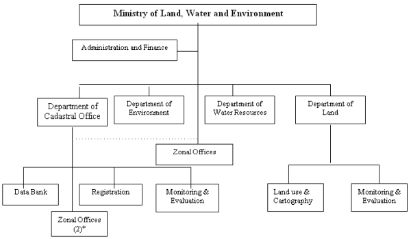
Figure 1: Organizational Structure of the MLWE
* Indicates the number of zonal offices established and are operational
In countries like Sweden, the National Land Survey is responsible for
surveying, but municipalities with the necessary competence are also
entitled to carryout property formation and registration (Swedesurvey,
1998, p. 2). But unlike that of Eritrea, in Sweden and many other
European countries there is standardization and competence. In Eritrea,
the relationship amongst the Departments is horizontal and all these
works need appropriate control, coordination and standardization. In
many countries, the land administration systems and their core cadastral
components (Annex 1, Figure 2) are essential infrastructure facilitating
implementation of land policies. In such systems the cadastral parcels
through land administration and management systems give the basic
infrastructure for running the interrelated systems within the areas of
land tenure, land value and land use (Enemark, 2003, p.6).
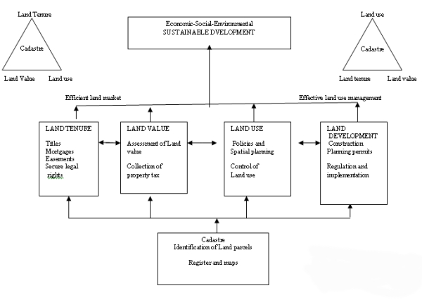
Fig. 2: A Global Land Administration Perspective (Enemark, 2001).
2.2 Practicalities and comprehensiveness of the system
There is access to land by both men and women; the main problem is
that usufruct right to agricultural land, which is main tenet and
content of the proclamation, is yet to be implemented according to the
Land Law. Besides, allocation of land lease to housing purposes and
upgrading squatter areas have not proceeded with the desired strides.
The costs could be high, but providing sites for housing purposes and
upgrading squatter areas to properly planned houses looks unavoidable.
This delay might have been caused by the ‘Border War’ with Ethiopia and
the ‘no war, no peace’ situation prevailing after the Ethiopian
government refused to abide by the ‘final and binding’ verdict of the
Border Commission. Moreover, there is inadequate institutional
infrastructure to carry out effective cadastral mapping/surveying work.
According to the Registration Law, registration is compulsory but
because of the above conditions it has not gone far beyond the voluntary
one. Records are also manually kept that makes integration of data
difficult. It is only with the help of computer technology and through
the registration and formation of computerized land information systems
(LISs) that reliable information for improved land management could be
attained. This offers good opportunities for automation of the cadastre
and the creation of LISs; provides better access to information,
facilitates data exchange and coordination. With the assistance of UNDP
Country office few computers, server, scanner, photocopier and printer
were made available, but are inadequate. Computer systems, however,
require infrastructure, good maintenance and communications and well-
trained operators (Osterberg, 1994, p. 9). Currently the office has
established a computerized cadastral system, but without its integral,
spatial part. The Office has inadequate capacities to integrate the
spatial data with textual data. There are still inadequate human
resource capacities to manage and run the system effectively and
efficiently. But, the development and management of such a system
requires technical know-how in programming and data base management.
Cadastre is an up-to-date land information system based on a division
of land into parcels. It gives information of rights (ownership,
usufruct, and lease), transactions of ownership and right, mortgages,
etc. Its main mission is to guarantee security of property ownership and
right, facilitate proper management of land and buildings contributing
towards the objectives of sustainable development. In order to ensure
its benefits, a harmonious horizontal relationship with the institutions
responsible for land registration, cadastral surveying,
building/habitation license, etc. is a prerequisite. The benefits
include:
- Guarantee security of ownership or right of use;
- provide credit through mortgaging buildings;
- protect registered state-owned land;
- reduce land disputes and less work for the courts;
- Improve conveyance of property transactions;
- Improve property management;
- Facilitate land lease rent;
- Produce statistical data for management; etc.
The Office of the Cadastre has the following medium and long term
objectives:
- To establish a parcel-based multi-purpose cadastre for
registering land, rights over land and other immovable property;
- To establish a modern computerized cadastral system.
The strategies pursued to achieve these objectives are:
- Establish and consolidate zonal offices, and develop a simple
and efficient cadastral system;
- Develop institutional infrastructure and capacities to manage
and sustain the system;
- Introduce and utilize up to date technology for cadastral/land
registry systems;
- Develop awareness within the public about the benefits of up to
date registers;
- Make the process simple, transparent, less bureaucratic and less
costly so as to encourage the public to get used to modern cadastral
system;
- Ensure that all land allocations, contractual agreements,
transfers, and mortgages are registered in time;
- Charge appropriate fees for services rendered and introduce
other mechanisms to generate funds for sustainability.
Cadastral systems need to be comprehensive. In countries such as
Sweden, Finland, etc. real property formation, mutation, cadastral
mapping, registration of real properties, ownership and legal rights,
valuation and taxation are all combined within one basic cadastral
system whereas in many parts of Europe the cadastre evolved as a support
for land taxation (ECE, 1996, p. 4). Here there is a high institutional
and resource strength and advantages for integrating and coordinating.
However, in Eritrea where there is institutional and resource
constraints the need for prioritizing is great. To make this a reality
feasibility studies of the objective situation in the cadastral system
was made. In the light of realities and findings, the following areas
are given priority in the transitional period:
- Land and immovable property in urban areas;
- Land and immovable property in semi-urban areas;
- Land allocated to tiesha houses (residential) around urban
areas;
- Land allocated on lease for dwelling, commercial agriculture,
and other social purposes.
In the light of the above priorities, objectives and strategies, the
Office is working in coordination with the Departments of cadastral
surveying/mapping and other partners. The cadastral surveying for
registration is being worked by different departments. These departments
use different cadastral surveying instruments such as GPS, total
Station, etc. The Land Department, for example uses GIS for its
spatially referenced system. But such works seriously require harmonious
coordination and standardization of work procedures. In the
Administration of cadastral data, national standards of data for use and
exchange, security and privacy, data protection, and legal liability,
etc. are essential.
Then what are the main constraints that hinder the implementation of
its plans and activities?
- Inadequate institutional infrastructure to carry out effective
organizational activities;
- Gaps in human resource capacities: technical and professional
capacities to run and develop the system; and
- Absence of Notary Public or ‘ real estate agents’ in the
remaining five Zobas (regions) for authenticity of agreement and
facilitating fast transactions of property.
A cadastre system should cover the whole country or a definite
geographical area and proceed step by step in order to provide the
necessary information and benefits. Our cadastral system unlike many
others lacks this. Besides, the need of parcel-based LIS for
coordination of information, standardization of data and procedures and
integration of new data is great. This work needs tireless efforts to
materialize. Moreover, there are other institutional constraints that
need considerations: appropriate office establishment, and the
re-organization of the notaries public in all zonal regions for
authenticity of contract and fast transfers of property.
3. THE WAY FORWARD
The German adaptation of a system of titles (19th century), and the
Swedish and Finish experiences of developing cadastres and land
registers from simple and less costly ways, developing progressively
into smoothly operating systems have flexible and progressive approaches
(Larsson, 1996, p. 39). Given the meager resources of poor countries
like Eritrea, the developed European system in general, and the Swedish
system in particular, a progressive system that evolved gradually and
has gone the furthest in the cadastral automation relative to other
countries seems to throw an insight for learning creatively.
In Eritrea, the conceptual understanding of the cadastral system
needs to further develop in the medium and long –term strategies. It
needs to go forward to implement comprehensive cadastral system learning
from other countries’ experiences and best practices. A more realistic
and pragmatic approach to our cadastral system is needed. Currently, it
is neither a core component of the land administration system nor has a
strong link between land administration and objectives of sustainable
development. It should sooner than later develop step by step following
the ‘progressive cadastre’ approach into a cadastre having comprehensive
coverage to ‘automated’ cadastre (Larsson, 1996, p.39). This could
possibly be achieved faster through cooperation with partners that could
enhance the needed institutional infrastructural building efforts.
Cadastral/land registry systems of Europe, for example are strongly
influenced by the concept of land information that have multiple uses,
automation, geocodes and digitization, and conversion of land related
information into spatial systems (Larsson, 1996, pp. 35-6). As land
information is a basis for planning development and control of land
resources, the only option left is to follow that way. However, it is
not an easy way: institutional capacity needs to be improved to meet the
medium and long term needs of the Office. Capacity building should be
seen ‘comprehensively in the wider context of developing institutional
infrastructures’ addressing the ‘societal, organizational, and
individual levels’ (Enemark, 2003, p. 4) for sustainable implementation
of land and cadastral policies.
Cadastral surveying work is a key in the development of
cadastral/land registry systems. Such work requires either a central
agency responsible for control, coordinating and standardizing these
works or is integrated with the cadastral/land registry systems.
Standardization is a key to developing national cadastral system,
computer networking and data exchange arrangements.
Our cadastral system charges fee for registration and other related
services provided, but are inadequate to develop and run the system. It
is heavily dependent on government funds; but this should not continue
indefinitely. With the development of the system, it needs to upgrade
the existing system of service fees and introduce other marketing
mechanisms to ensure its sustainability.
4. CONCLUDING REMARKS
There is a saying ‘a journey of one thousand kilometers begins with
one step’. The Eritrean cadastral system, though has a tradition of more
than a century, it is still in its infant stage. It is incomprehensive
and its computerized cadastral system not yet integrated; its most
important integral part, the spatial part. Sooner than later this has to
be done. It is not a choice to be made but a must that has to be done by
a country to properly manage land and its resources and fit within the
global economy competitively.
The ‘progressive cadastre’ that goes step by step to a national
coverage and automation is a good approach that has to be followed.
However, institutional infrastructural buildings efforts demand
seriousness of purpose and resource. Besides, gaps in human capacity are
required to be upgraded with appropriate education and training for
efficient and effective functioning. The success of cadastral systems
depends heavily on competence and technical know- how of staff. Hence,
these works demand serious commitment by the Office as well as higher
authorities. It is only through these efforts that a modern computerized
cadastral system could be established and developed.
Other countries’ experiences also show that the success of cadastral
systems depends neither on its laws nor on its technical complexity. It
heavily depends on whether it protects land and property rights,
facilitates fast and efficient transfer of rights and ownership and is
up-to-date. Guaranteeing this is imperative.
REFERENCES
Enemark, S. (2003) Capacity Building for developing sustainable Land
Administration Infrastructures, Paper presented at WPLA/FIG Workshop
Athens, 28 -31 May 2003
Economic Commission for Europe (ECE) (1996) Land Administration
Guidelines, United Nations, New York and Geneva
Government of Eritrea (GoE) (1994) Macro Policy, Asmara, Eritrea
GoE (1994) Proclamation NO. 58/94: A Proclamation to reform the
system of Land Tenure in Eritrea, Asmara, Eritrea
GoE (1997) Proclamation NO. 95/1997: A Proclamation to Provide for
the Registration of Land and Other Immovable Property, Asmara, Eritrea
GoE (1997) Legal Notice NO. 31/1997: Regulations for the Distribution
and Administration of Land, Asmara, Eritrea
Larsson, G. (1996) Land Registration and Cadastral Systems, Longman
Malaysia, CLP Economic Commission for Europe (1996)
Osterberg, T. (1994) Cadastre: A Land Information System, Swedesurvey
–Gavle, Sweden
Swedesurvey (17 August- 25 September 1998) Real Property and Land
registration in Sweden, Gavle, Sweden
Swedesurvey (17 August- 25 September 1998) Land Management in Sweden:
Development and Management of Cadastral and Land Information Systems
(LISs), Gavle, Sweden
Weldegiorgis, H. (1998) the Development of Cadastral and LISs in
Eritrea, a Country Report to the Development and Management of Cadastral
and LISs, Gavle, Sweden
Weldegiorgis, H. (2007) Cadastral Office: Historical Background, Work
Guidance and Procedure, Cadastral Office, Asmara, Eritrea
Weldegiorgis, H. (2008) Cadastral Policies, Objectives and
Strategies, Cadastral Office, Asmara, Eritrea
Wikipedia (2009) The Free Encyclopaedia, en.wikipedia.org/wiki/Asmara
World Book Encyclopaedia (1994) the World Book Encyclopaedia, N-O
Volume 14, World Book, Inc., Chicago
CONTACTS
Habtemicael Weldegiorgis (M Sc., Dev. Mgn’t)
Director General
Cadastral Office
Ministry of Land, Water and Environment (MLWE)
P. O. BOX -976
Asmara
ERITREA
Tel: + 291-1-124253 (Office), + 291- 1- 202414 (Res.)
Fax: + 291- 1- 116381(Off)
E-mail:
habtemicael_weldegiorgis@yahoo.com
 |


