Article of the Month -
April 2005
|
The Development of Land Information Policies in the Americas
Stig ENEMARK, Denmark and John PARKER, Australia
 This article in .pdf-format.
1) This paper has
been prepared to the FIG Working Week / GSDI-8 Conference in Cairo, Egypt,
April 16, 2005 and is based on the Special Forum held at the INEGI
headquarters in Aguascalientes on 26 and 27 October 2004 with a theme of
“The Development of Land Information Policies in the Americas”.
1. BACKGROUND
There are difficulties being faced by many United Nations member States
in designing appropriate spatial data infrastructures to support effective
land administration, and in integrating cadastral and topographic spatial
data, especially in digital form. Therefore, there is a need to improve
capacity to design, build and manage land administration systems, which
incorporate appropriate spatial data infrastructures.
In many cases there is a lack of understanding of the important role
spatial information (i.e. information that provides location on the earth,
e.g. to allow accurately plotting on maps) plays in land administration
projects, particularly in developing countries.
In many countries the land ownership and registration function is located
in one department e.g. the justice or legal department of government, while
the geodetic survey and mapping function is located in another department,
and often has very little if anything to do with the ownership and
registration function. When a land administration project is initiated and
funded, say by the World Bank, the government’s institutional arrangements
of departments can make it very difficult to access information and involve
the skills and knowledge between different departments, e.g. between the
survey and mapping functional area and justice and legal functional area.
With this background the objective of the special forum was:
- To establish an awareness of the economic and social value for
decision makers, of the importance of developing land policies that
effectively and efficiently incorporate appropriate spatial data
infrastructures (SDI´s).
- To develop an overall understanding of the economic and social that
results from integrating the land administration/cadastre/land
registration functions with the topographic mapping function.
2. THE SPECIAL FORUM
The UN, FIG, PC IDEA Inter-Regional Special Forum on “Development of
Land Information Policies in the Americas” was based on a resolution
adopted at the Seventh United Nations Regional Cartographic Conference for
the Americas held New York January 2001. The International Federation of
Surveyors (FIG) was tasked with taking the lead role in organizing the
special forum with support from the United Nations Statistics Division,
Department of Economic and Social Affairs, and the Permanent Committee on
Spatial Data Infrastructures for the Americas (PC IDEA) and was hosted by
the National Institute of Statistics, Geography and Informatics (INEGI) in
Aguascalientes, Mexico.
Invitations were issued by the United Nations to Ministers of Government
who have responsibility for the above functions, or their senior managers
who have a policy responsibility, to attend. There were about 60 delegates
from 18 countries together with representatives from the United Nations, PC
IDEA, World Bank, and the Pan American Institute of Geography and History
(PAIGH).
The initial issue was funding, which took some time to resolve. It is
therefore gratefully acknowledged the support and funding provided by the
Canadian Government through Natural Resources Canada, the United States of
America Government through USGS/FGDC and USAID, the World Bank through the
Danish Trust Fund, and PAIGH.
The program of the special forum consisted of four key-note presentations
followed by some case studies from various regions of the world, and a
number of case studies from the Latin American countries. The case studies
followed a common format in order to ensure consistency and contextual
focus. All papers were prepared by personal invitation in order to ensure
consistency with the special forum profile. Sessions were allocated to
discussions of the case studies and for short presentations and discussions
on the challenges facing the Americas with respect to the theme of this
forum. These provided the opportunity for those attending to either comment
on a presentation or provide some insight into the situation within their
own country. The full papers and the ppt-presentations are available in
English and Spanish at the FIG website on
http://www.FIG.net/pub/mexico.
A final report of the Special Forum will be tabled at the Eighth United
Nations Regional Cartographic Conference for the Americas to be held in June
2005 in New York. The report will be entitled the “Aguascalientes
Statement” that will also be published in the FIG series. The report
should assist member States to develop appropriate institutional, legal and
technical processes to integrate land administration and topographic mapping
programs within the context of a wider national strategy for spatial data
infrastructure. The Aguascalientes Statement states the following:
The Special Forum strongly endorses the need for
Latin American and Caribbean countries to:
- Foster modern land policies and associated spatial data
infrastructures so as to better support social, economic and
environmental sustainability.
- Determine policies and programs for educational, professional, and
institutional capacity building that will ensure the development of
appropriate land administration systems and associated spatial data
infrastructure.
- Develop appropriate institutional, legal and technical processes
to integrate land administration, cadastre and land registration
functions with topographic mapping programs within the context of a
wider national strategy for spatial data infrastructure (SDI).
|
3. A FOCUS ON LAND MANAGEMENT
Land Management is a very complex and interdisciplinary concept that
includes a mix of technical, natural, and social sciences. Land management
can be described as the processes by which the resources of land are put
into good effect. It is about land policies, land rights, property
economics, land-use control, regulation, implementation, and development.
Land management encompasses all those activities associated with the
management of land as an asset and a resource to achieve sustainable
development.
Within the country context, the land management activities may be
described by the three components: Land Policies, Land Information
Infrastructures, and Land Administration Functions in support of Sustainable
Development.
A modern land administration system acts within the environment of
adopted land policies that fulfill political objectives with regard to land
issues. It also acts within an institutional framework that imposes mandates
and responsibilities on the various agencies and organizations. Basically
such systems are embedded in the historical, cultural and judicial setting
of the individual country. However, in spite of the different origins the
systems seem to merge into a global model serving some basic societal needs.
Such a global model is shown in the diagram below.
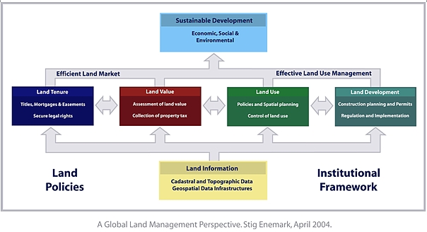
The operational component of the land management paradigm is the range of
land administration functions that ensure proper management of rights,
restrictions and responsibilities in relation to property, land and natural
resources.
These functions include the areas of land tenure (securing and
transferring rights in land); land value (valuation and taxation of land and
properties); land-use (planning and control of the use of land and natural
resources); and land development (utilities, infrastructure, construction
planning, permits, and implementation).
The land administration functions are based on and are facilitated by
appropriate land information infrastructures that include cadastral and
topographic datasets and provide access to complete and up-to-date
information of the built and natural environment. The information on land
and properties permeates through the overall system and provides the basic
infrastructure for running the administrative systems within the four
interrelated areas.
The land information area should be organized to combine the cadastral
and topographic data and thereby linking the built environment (including
the legal land rights) with the natural environment (including environmental
and natural resource issues). Land information should be organized as a
spatial data infrastructure at national, regional and local level based on
relevant policies for data sharing, cost recovery, access to data,
standards, etc. It is generally recognized that about 70 per cent of all
government information is geospatially based.
Sound land management is the operational processes of implementing land
policies in a comprehensive and sustainable way. In many countries, however,
there is a tendency to separate land tenure rights from land-use rights.
There is no effective institutional mechanism for linking planning and
land-use controls with land values and the operation of the land market. The
problems are often compounded by poor administrative and management
procedures that fail to deliver the services that are needed. Investment in
new technology will only go a small way towards solving a much deeper
problem, which is the failure to treat land and its resources as a coherent
whole.
4. FACING THE CHALLENGES
Good land management will help promote economic and social development in
both urban and rural areas. For developing and transition countries, land
reform policies are key components in achieving these goals. The challenges
in this regard relate to educational, professional, and institutional
issues.
With few University programs in Land Management, the Latin American and
Caribbean region is lacking experts to support systems of sustainable land
administration infrastructures. There is a need to develop comprehensive
University programs with a broader profile than a technical focus. And there
is need to share efforts and information between educational institutions in
order to serve the basic land administration needs in the region. Donors
such as the World Bank and other aid agencies where they are building land
administration systems should include the educational component to ensure
long term sustainability.
In many Latin American and Caribbean countries there is a need to
establish professional associations that can set standards, enforce
professional development, and interact with sister associations within the
region and world wide through international NGO´s such as FIG. This will
increase awareness about regional and global opportunities for technological
development and transfer, institutional strengthening, and the exchange of
managerial and SDI experiences.
With regard to institutional arrangements it is understood that one model
will not fit all countries. In spite of sharing much the same geography and
history, the Latin American and Caribbean region shows diverse approaches to
land information and land registration systems, as well as to the building
of spatial data infrastructures. Such systems are embedded in the
institutional development of the country or jurisdiction and the
institutional arrangements may change over time to better support the
implementation of land policies and good governance.
In terms of capacity building attention should be given to sustaining
existing educational facilities in terms of institutional development,
quality management, and financial support. Attention should also be given to
the development of one or more Regional Centers in the Latin American and
Caribbean region for Education and Research in Land Administration. Such
centers should act as ongoing bodies of knowledge and experience in land
administration and using actual projects as long-term case studies and
operational laboratories. The centers should provide educational programs
and supervise establishment of educational programs at other institutions.
The centers should develop guidelines for capacity assessment in land
administration and interact with national institutions, international
academics and professional bodies to assist regional and local development
serving regional and local needs.
5. FINDINGS AND RECOMMENDATIONS
The Special Forum discussed and took note of the major challenges faced
by the Latin American and Caribbean region for the creation and maintenance
of land administration infrastructures for poverty reduction, economic
growth, and sustainable development. The presentations from various Latin
American countries were very different, as experiences depend on social and
cultural factors. However, most countries in the region seem to share the
same needs in terms of capacity building for educational and institutional
development in land administration. Key findings and conclusions are
highlighted below:
- It is important that the countries in the region develop a wider
vision for the creation of knowledge, reduction of poverty, and
sustainability. In this regard, it is time to handle change and to
convince politicians and decision-makers.
- The need to formulate national policies, legal frameworks, and
standards for land administration, land information and spatial data
infrastructure is widely acknowledged.
- It is important to demonstrate the economic value of land
administration systems and SDI´s to high-level decision-makers,
considering the large number of priorities they are facing. This should be
based on further case studies from the Latin American and Caribbean region
- Visionary leadership and also short term initiatives such as shared
data collection projects are recognized as important to establish
inter-organizational and inter-regional cooperation. It is necessary to
ensure coordination between the key players, and to break down human,
technical and political barriers.
- It is important to have a focus on the users needs in order to build
trust amongst the beneficiaries of the systems. Credibility and
transparency must be built into the processes, including institutional
continuity and continuous modernization.
- The need for capacity development of human resources through the
building of programs for education and training in land administration
must be reinforced. This also applies to the establishment of national
professional bodies to interact at regional and global level.
- There is a need to integrate land administration, cadastre and land
registration functions with topographic mapping programs within the
context of a wider national strategy for spatial data infrastructures.
6. FINAL REMARKS
The conclusions can be summarized in the “Aguascalientes Statement”
as presented earlier in this paper. The Special Forum recommends that
politicians and decision makers at various levels take note of this
statement and make efforts to ensure its implementation.
REFERENCES
Information and references on the Special Forum can be accessed through
the FIG web site at
http://www.fig.net/pub/mexico/index.htm. The Aguascalientes Statement is
also available through the FIG website at the address
http://www.fig.net/pub/figpub/pubindex.htm.
BIOGRAPHICAL NOTES
Stig Enemark is Head of the School of Surveying and Planning at
Aalborg University, Denmark, where he is Professor in Problem Based Learning
and Land Management. He is Master of Science in Surveying, Planning and Land
Management (1966) and he worked for ten years as a consultant surveyor in
private practice. He is currently the President of the Danish Association of
Chartered Surveyors. He was Chairman of Commission 2 (Professional
Education) of the International Federation of Surveyors (FIG) 1994-98. He is
an Honorary Member of FIG and he is Vice-President of FIG 2005-2008. His
teaching and research are concerned with land administration systems, land
management and spatial planning, and related educational and capacity
building activities. He has undertaken consultancies for the World Bank and
the European Union especially in Eastern Europe and Sub Saharan Africa. He
has more than 200 publications to his credit, and he has presented invited
papers to more than 50 international conferences.
John Parker is an international land administration consultant
specializing in quality management, professional practice and management and
geographical names. He was Surveyor General of Victoria, Australia for nine
years and had spent nineteen years in private practice in a multi
disciplinary firm. Currently he is actively involved in the International
Federation of Surveyors and was chair of FIG Commission 1 (Professional
Standards and Practice) 1998-2002. Membership of professional associations
includes the Institution of Surveyors Australia and Spatial Sciences
Institute. Papers have been presented and published at a range of events,
including international forums, on a wide range of subjects.
CONTACTS
Professor Stig Enemark
Head of School of Surveying and Planning
Aalborg University, 11 Fibigerstrede
9220 Aalborg
DENMARK
Tel. + 45 9940 8344
Fax: + 45 9815 6541
Email: enemark@land.aau.dk
Website: www.land.aau.dk/~enemark
Professor John Parker
International consultant
PO Box 110
Brunswick East
Victoria 3057
AUSTRALIA
Tel. + 61 (0) 408 364 159
Fax + 613 9381 1378
Email: park106@dcsi.net.au
 |


