Accessibility to Land Administration by Grassroots
Stakeholders in Vietnam: Case study of Vinh Long Province
Mau Duc NGO, Vietnam; David MITCHELL, Australia;
Donald GRANT, Australia;
and Nicholas CHRISMAN, USA
1)
This peer reviewed paper was presented at the FIG Working Week 2016 in
Christchurch, New Zealand. The article presents the evaluation of
grassroots stakeholders’ accessibility to the land administration, and
to the development of a modern land administration system in Vietnam.
Key words: access to land;
e-governance; land management; land stakeholder perception; land
administration; Vietnam
SUMMARY
The trend in modern land administration systems towards e-land
administration aims at improving access to land information and services
for all stakeholders. Vietnam is no exception in this trend. The
government has made large investments to develop the land information
and registration system with the strong support from donor-funded land
registration projects. One aim of land registration and titling is to
build a transparent land administration system. Most investments have
focused on the development of a computerised system to improve land
administration delivery services. However, there have been some
technical and non-technical factors which have become barriers to the
implementation of an effective land administration system in the
country. This paper presents the evaluation of grassroots stakeholders’
accessibility to the land administration, and to the development of a
modern land administration system in Vietnam. This research is based on
a case study which investigates the challenges for development of a
conceptual spatial data infrastructure to increase access to land
information by all stakeholders in Vietnam.
In Vietnamese:
Xu hướng hình thành hệ thống quản lý đất đai hiện đại tiến tới hệ
thống quản lý đất đai điện tử cải thiện sự tiếp cận thông tin và các
dịch vụ đất đai cho tất cả các đối tượng có liên quan. Việt Nam không
nằm ngoài xu hướng này. Trong thời gian vừa qua, Chính phủ Việt Nam đã
đầu tư một lượng kinh phí lớn trong lĩnh vực đất đai với sự hỗ trợ mạnh
mẽ từ các dự án tài trợ. Mục tiêu của công tác đăng ký đất đai và cấp
giấy chứng nhận quyền sử dụng đất là tiến tới xây dựng một hệ thống quản
lý đất đai minh bạch. Hầu hết các dự án đầu tư đã tập trung vào việc
phát triển một hệ thống thông tin đất đai để dần cải thiện dịch vụ quản
lý đất đai. Mặc dù vậy, có một số hạn chế cả kỹ thuật và phi kỹ thuật đã
cản trở việc thực hiện một hệ thống quản lý đất đai có hiệu quả trên cả
nước. Bài báo này trình bày kết quả khảo sát việc tiếp cận thông tin và
các dịch vụ đất đai của người dân ở cấp cơ sở và đánh giá sự phát triển
của một hệ thống quản lý đất đai hiện đại ở Việt Nam. Nghiên cứu này
được thực hiện trên một địa bàn cụ thể, khảo sát những khó khăn, thách
thức trong việc phát triển một cơ sở hạ tầng dữ liệu không gian để tăng
cường tiếp cận thông tin đất của tất cả các bên liên quan ở Việt Nam.
1. INTRODUCTION
Land and geographic information underpins many of the objectives and
strategic goals of governments, including natural resource management,
environment monitoring, land-use control, climate change adaption, and
disaster risk management, as well as socio-economic development. Spatial
and non-spatial information about land are important for government in
land management and administration decision-making, but also for
landholders in making decisions about their land. The role of spatial
information to support decision making of local, national, regional and
global issues was recognised more than two decades ago at the Rio Summit
(1992), and is still central to discussions about the Sustainable
Development Goals. Land information has often been described as an
element which presents the location of resources and helps people to
understand the relationships between real objects and resources. This
concept enables the visualisation of resources’ locations to support
planning and management. Land administration assists in the protection
of scarce community resources by allocation of the rights to them,
creation of restrictions on them; and establishment of responsibilities
of related stakeholders. The utilisation of spatial data and services
allows decisions to be made about optimising the use of land and becomes
one of the key principles for sustainable management and development
(Muggenhuber, 2003; Steudler & Rajabifard, 2012).
Furthermore, the security of land use rights (land tenure), together
with information about access to land, has been identified as important
for the reduction of poverty (FAO, 2012; Maxwell & Wiebe, 1999; Quizon,
2013; Widman, 2014) and meeting the broader sustainable development
goals objectives. The Voluntary Guidelines on the Responsible Governance
of Tenure of Land, Fisheries and Forests in the Context of National Food
Security (FAO, 2012) calls on States to recognise, record, and respect
all legitimate rights to land. The way that land rights may be recorded
is in the formal land administration system. However, it is often stated
that approximately 70% of all land rights globally are not recorded in
the formal land administration system.
In Vietnam, information on property rights, including land use rights
and related land information, has recently been recognised as an
important competitive indicator to attracting investors at the
provincial and municipal level (Malesky et al., 2015). According to Thu
and Perera (2011), access to land is a sensitive issue that may hinder
foreign and private investments, as the stability of land use is a
factor that multi-national enterprises consider when investing in
Vietnam.
Stakeholder understanding of, and participation in, land
administration process is an important element in land administration
delivery and the provision ofland-related services. A transparent land
administration system requires active participation by individuals,
households and organisations to increase access to land informaiton. As
the largest user, grassroots stakeholder’s understanding and
participation are critical when assessing the development,
implementation, and maintaince of land administration.
Since the late 1990s, the Government of Vietnam has made large
investments to develop a modern land administration system including
land registration and the issuance of Land Use Right Certificates
(LURCs) with the strong support from international donors such as
Australia, Sweden, ABD, and The World Bank Group (World Bank, 2010).
Such a modern transparent system will contribute a good governance and
strengthen the trust of local people in land services and activities.
The institutional arrangements have been improved by separating the
state administration organisations and public service provision units,
together with the establishment of a unified and decentralised system of
land administration at all levels over the last decade (Vietnam National
Assembly, 2003; World Bank, 2009). However, there has been a
considerable gap between the land policy and its practical
implementation to ensure the access to land by stakeholders. For
instance, the standard requirements for land registration offices have
not yet been developed and applied, while the procedures for the land
titling process have retained complexity which may encourage corruption
in the land sector (Embassy of Denmark, Embassy of Sweden, & World Bank,
2011).
There has been an estimated $60 million of investments per year for
cadastral survey and mapping, including procurement of surveying
equipment and technical services (World Bank, 2011). However, several
reviews have reported limitations in the land sector in Vietnam,
especially in term of ensuring and increasing efficient access to land
information by stakeholders. As a consequence, over the last few years
the land sector in Vietnam has been rated in the top three sectors for
corruption (DEPOCEN, World Bank, UKAID, & VTP, 2014; Martini, 2012;
World Bank, 2010; World Bank & Government Inspectorate of Vietnam,
2013). There have been both technical and non-technical issues that have
caused problems. In particular, land administration related services and
activities, and accessibility to land information for land users, needs
further development.
This paper presents the results of one element of a PhD research
project being undertaken to develop a conceptual spatial data
infrastructure model for land administration system (SDI Land) in
Vietnam with a case study of Vinh Long Province (hereinafter called Vinh
Long). The model aims to increase access to land information by all
stakeholders. This paper considers the information needs of one group of
these stakeholders - those at grassroots level.
This research employed a multi-method setting using a case study
strategy that includes both quantitative and qualitative methods. The
qualitative methods involved interviews of related stakeholders,
including managerial officials, policy makers at the central ministries,
and technical and managerial staff at provincial level, international
organisations, donors, private and academia sector as well as community
members through personal interviews and focus group discussions. The
quantitative methods included questionnaires about people’s attitudes,
thoughts, and evaluations of engaging with land registration services at
the government agencies; the difficulties encountered, and deficiencies
and expectations in accessing land information.
The grassroots stakeholder consultation was conducted in Vietnam in
late 2013. Three focus group discussion meetings and 160 individual and
household questionnaire survey were conducted in Vinh Long. The
selection of participants was made randomly by third parties to ensure
the nature of collected data and the voluntary participations. However,
there was a balance in both gender and cultural background for the
participants of focus group discussions and questionnaires at the
grassroots level. As the research involved human participants, the
ethical issues were considered and approved to conform to the Australian
National Statement on Ethical Conduct in Human Research before the
fieldwork conduction. The data collection was in Vietnamese language and
was then analysed by computer-aid data analysis software packages,
including MS. Excel and QSR NVivo.
2. VIETNAM LAND ADMINISTRATION
2.1 Land Tenure in Vietnam
In Vietnam, land belongs to whole population, managed by the State
and while private ownership of land is not recognised, land use rights
can be issued (Vietnam National Assembly, 2013a). The State recognises
and protects the land use rights of land users (Vietnam National
Assembly, 2013b). In this context, as a special property, the meaning of
the term land use right in Vietnam is not significantly different to the
meaning of land ownership. In other words, it is the most secure form of
tenure for landholders in Vietnam. In certain areas LURCs are allocated
to individuals, households, organisations, and communities (hereinafter
called land users) to use stably. No LURCs are issued for land on which
land use rights have not been allocated, and this land remains under the
control of the State.
LURCs are essentially usufruct rights, meaning that the land users
may use land, but cannot own the land. Land use rights entitle land
users to exchange, transfer, inherit, mortgage, lease, sub-lease,
bequeath and donate land use rights, guarantee and contribute capital
using land use rights (Vietnam National Assembly, 2003).
According to data from the General Department of Land Administration
(GDLA), as of 2013, about 90% of agricultural land area, 75% of urban
residential land area, 90% of rural residential land area, and 70% of
forestland area had been issued LURCs. However, cadastral records,
including cadastral maps, are largely incomplete, inaccurate, and
out-of-date; and thus cannot support the needs of land related services
delivery. By the end of 2014, there has been only about 20% of LURCs
issued with the names of both spouses as promoted and regulated by land
laws and policies. The system itself is cumbersome and inefficient,
lacks transparency, and has not yet provided the end-users with quality
services. As a result, it is difficult and costly to conduct land
transactions or to use LURCs for mortgaging to access to credits.
2.2 Vietnam’s Decentralised Land Administration System
Vietnam’s land policies are administered through a hierarchy of
authorities at the central level, sixty-three provinces and cities, more
than seven hundred districts and over ten thousand communal
administrative units (including communes, wards and towns). The Vietnam
land administration system is a multi-level and decentralised system.
In 2009, GDLA was re-established under the Ministry of Natural
Resources and Environment (MONRE) and has become the primary central
level body in the country for land administration activities. GDLA is
responsible for advocating with the other government agencies for
necessary laws to reform public land, land registration and other land
regulations for more efficient resource management system in the
country. The activities of GDLA focus on state administration of land,
directing and organising inspections of land nationwide and directing
the surveying, measurement, drawing and management of cadastral maps,
land use status maps and land use planning maps nationwide. GDLA is
based in Hanoi.
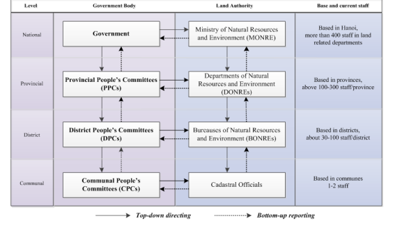
Figure 1: Vietnam Decentralised Land
Administration System
At the provincial and district levels, the natural resources
departments as well as the Commune People’s Committees, supported by
cadastral officials are responsible for land management within the
administrative boundaries. Respectively, the upper level authorities
provide guidelines to lower ones. Staff and organisations belong to
respective people’s committees at the same level (Figure 1). Most of the
land administration activities happen at the local levels.
3. VINH LONG CASE STUDY
3.1 Land Tenure Profile in Vinh Long
Located in the Mekong Delta region, lying between two major rivers in
the area (Figure 2), Vinh Long plays an important role for agricultural
production and is well known for fishing in the south of Vietnam. Like
other traditional agricultural provinces, land is important to people
for both residential and farming purposes. Vinh Long is the smallest
province covering an area of approximately 1,500 km2 and has a
population of 1.04 million (http://www.vinhlong.gov.vn/Default.aspx?tabid=1255
accessed on August 21, 2015) over approximately 265,000 households with a
density of 700 people /km2. The Province is subdivided into eight
district-level administrative units including six districts, a
district-level town, and a city; 109 communal-level administrative
units, including 94 communes, 5 communal-level towns, and 10 wards.
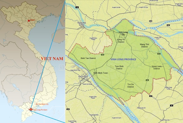
Figure 2: Vietnam and Vinh Long Province in the south of Vietnam
(non-scale maps; extracted from www.vietbando.vn)
Vinh Long was one of nine provinces covered by a World Bank funded
project (VLAP) implemented during 2009-2013, and extended and closed by
end of 2015. The Province was considered as a lead province in the
project implementation with good progress, strong commitments of
provincial leadership, and the active participation of land users during
the project implementation. The figure of land tenure in the Province as
of 2014 is presented in Table 1. 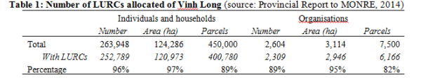
The land administration system of Vinh Long is similar to the other
provinces with the DONRE belonging to PPC and nine BONREs at district
level. At the provincial and district levels there are land registration
offices organised to deal with all land administration activities
related to grassroots stakeholders. Cadastral officials at communal
level assist with the CPCs and BONREs land management related
activities.
3.2 Selection of Case Study Districts
Three communal administrative units were selected including Ward 2 of
Vinh Long City, Trung Thanh Tay and Trung Hiep communes of Vung Liem
District to represent for all three urban, peri-urban and rural
communities.
The selection was based on number of criteria including technical,
professional and organsational development as well as academia
collaboration of the provincial leaders in the land sector.
Demographical distribution and geographical range were also taken into
consideration of the case study areas. Other criteria included the
availability of as many land services as possible, the commitment of
provincial leaders and the accessibility of investigators. Land tenure
profiles of the three communes were similar to the whole province as
shown in Table 1.
These following sections present the results of the interviews, focus
group discussions and questionnaires and reflect the accessibility of
grassroots stakeholders to land administration related information and
services through a variety of research methods. These sections firstly
discuss the understandings of local people on land use rights and their
importance to them then present the findings on the barriers and issues
of land related services and the recommendations on the land
administration before analysing the accessibility to land information at
grassroots level.
4. STAKEHOLDER AWARENESS OF LAND USE RIGHTS
4.1 Understandings of Land Use Rights
Of the 122 questionnaires responses, 104 individuals and households
(equivalent to 84.6% of participants) had been granted LURCs. This is a
large number in comparison with the average percentage (72%) reported by
provinces to the MONRE (World Bank, 2010) and the figure as of 2013
reported by GDLA. However, only 69 (equivalent to 56.6%) are residential
LURCs.
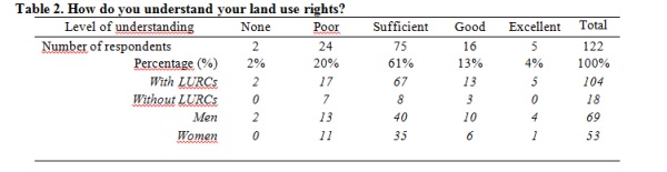
Of the 122 households questioned, 75 (about 61%) indicated that they
sufficiently understand what their land use rights are (Table 2).
However, the majority of participants of the focus group discussions
considered that they are not really good at understanding the land use
rights mentioned in the Law on Land and related legal documents due to
the complicated technical interpretation and understandings.
There was little difference in understanding of land use rights
between men and women in relation to their understanding of their rights
to land (including restrictions and responsibilities) are shown in Table
2. Slightly fewer men (78.26%) stated that their understanding of land
use rights were at the level of competence or higher, compared to women
(79.25%). These results reflected the benefits to women of public
awareness campaigns undertaken under VLAP during the last few years.
Also, the understanding of land users did not differ depending on
whether they had been granted or not granted LURCs.
In the urban area focus group discussions, about 80% of attendees
perceived that they understood their land use rights sufficiently. Some
of them could list the rights of land users set by the law; others could
do this in languages that differentiated terms from the language used in
the legal documents. They could also provide examples for others to
understand and match the ideas. Even though individuals were aware that
they could mortgage their LURCs to access to loans from the commercial
banks, they still were confused about the procedures and the credit
thresholds for borrowing. Although, the majority of attendees were
unaware the value of their land, a few of them had mortgaged their LURCs
for access to credit. In most cases, land users did not understand the
procedures of land valuation. Borrowers simply believed the commercial
banks had applied the right prices set by the government. The
observation and discussion with local people suggested that due to the
limited size of loans and the complicated procedures, many land users,
especially the farmers hesitated contacting the commercial banks to
access credit. Disregarding high interest rates and risks, farmers still
seek “black credits”.
4.2 The Importance of Land Use Rights
Table 3 presents the results of questionnaire on the importance of
land use rights. Participants were asked to score the relative
importance to them of six property rights related to their land use
rights – as given by the Land Law 2003 (Vietnam National Assembly,
2003).
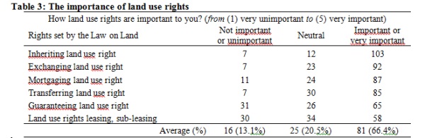
Overall, 81 respondents (66.4%) indicated that the land use rights
are important or very important, whilst only 13.1% of respondents
addressing that the land use rights are either very unimportant or
unimportant. The rest 20.5% of respondents perceived that the land use
rights are neutral (neither important nor unimportant) to them.
Within the six fundamental property rights of land users listed
above, inheritance of the land use right was evaluated as the most
important right by over 103 (84.4%) participants. The next most
important was the exchange of land use right by 92 (75.4%) respondents.
Additionally, the field observation suggested that the exchange of land
use right supports land users, particularly farmers, to exchange land
use for expanding the farming investments.
Both guaranteeing land use right, and leasing or sub-leasing of land
use rights, were at the bottom of the table of property rights with an
average of just over 50% of respondents suggested they were important.
In general, the results are relatively consistent with the output of
focus group discussions at the three communes. Despite the differences
of locations, communities, and participants’ backgrounds, the majority
of respondents recognised the significant importance of land use rights
to them. The results of focus group discussions could be summarised as
follows:
- Inheritance of land use rights was important to grassroots
individuals and households since all twenty-seven respondents stated
that the inheritance of land use right is an essential right to land
users;
- Mortgage and exchange of land use rights is of great
significance to local land users. The majority of respondents (72%)
in the focus group discussion commented that the mortgage of land
use right was a basic important right despite only few of them
having accessed credit by through mortgaging their land use right.
More than half of the respondents (56%) in peri-urban and rural
areas indicated that exchanging the land use right encouraged them
to use larger land parcels for farming developments;
- One respondent shared their experience of using lease or
sub-lease of land use rights. No respondent mentioned that
guaranteeing the land use right would bring benefits to them.
Nevertheless, there was misunderstanding about the two terms
‘guaranteeing’ and ‘mortgaging’ the land use right, which was
identified when the participants discussed the ease of accessing
credit by using LURCs.
In summary, the above results have shown the importance of land use
rights as well as the benefits of issuing land use rights certificates
to land users. However, a small number of land users successfully
accessed credit by mortgaging the land use right. Land users, especially
in rural areas were still unwilling to, or faced difficulty in, dealing
with commercial banks for loans.
5. Accessibility to Land Administration Services
5.1 Barriers to Land Registration Service Participation
This section presents and discusses the experiences of land users
participating in land registration services. The results are presented
in Table 4.
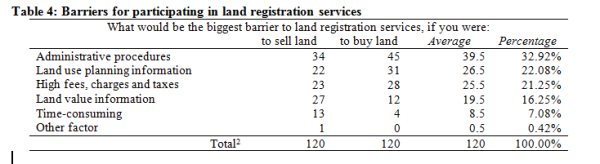
[2] There were 120 participants answering these two questions.
Approximately one-third (32.92%) of respondents indicated that
administrative procedures were the largest barrier for them to do land
registration. The next largest barrier was considered to be limitations
in land use planning information with an average of 22.08% of
respondents. However, there was a difference in the responses for
selling and buying land. While 22.13% of sellers revealed the
limitations in land value information being the second largest factor;
25.41% of buyers acknowledged the difficulty in accessing land use
planning, which relates to land use purpose, land recovery and
acquisition, and land compensation being the second impact for them to
decide.
Time taken to process the service was not considered as a barrier for
the majority of sellers and buyers. Of the responses, just thirteen
sellers and four buyers stated that time-consumption was the factor in
completion of land registration. These figure made an average of 7.08%
of responses.
Generally, the above statistics are consistent with the outputs of
focus group discussions. However, there were some differences between
rural and urban communities. Attendees living in urban and peri-urban
areas were most concerned about the limitation of land use planning
information, citizens living in rural areas were more worried about the
fees, charges and taxes. There were 34 comments from participants
regarding the barriers on land registration services at the focus group
discussions. The results were summarised and could be categorized into
two groups of provision of land information and land policy practices at
grassroots level:
- More than two-third of respondents (73.33%) stated that
the limitation and lack of land use planning information and
documents affected their decisions for transferring land and
involving land registration services;
- The land-related fees, charges and taxes were of concern to the
attendees at the rural area focus group discussions. All respondents
indicated these fees, charges and taxes were still particularly high
and became the biggest barrier (57% of responses from rural area
focus group discussions in particular, or 26.47% of responses from
all three meetings overall). Financial reasons were also mentioned
by 19% and 18% of respondents at urban area, and peri-urban area
focus group discussions, respectively;
- One-third of respondents mentioned the difficulty of
accessing land value information for related land transactions,
including selling, buying and mortgaging. Those people considered
that this limitation was the most difficult for them to sell and buy
land at the best prices. This difficulty was mentioned by14.71% of
respondents;
- There was a similar response regarding land related
administrative procedures at the focus group discussions. Overall,
17.65% of responses stating that the administrative issues were
significant reasons preventing them from participation in land
registration process. The figures were similar at the three
meetings, all between 17-20% of responses.
- At the focus group
discussions, only one respondent mentioned time consumption in land
administration services as a big issue. However, some other
attendees agreed that the land registration services took longer
time than the regulation, especially in applying for LURCs.
Limitations exist in the dissemination of land use planning
information as people interviewed perceived that they had to directly or
indirectly contact cadastral officers to access land use planning
information.
Transferring land informally:
Approximately 12% of participants indicated that they had informally
transferred land over three communes. Due to the only small number of
respondents, the results are not conclusive. However, they provide some
indications of the factors in informal land transactions. The reasons
varied and came from financial issues, administrative procedures,
timing, and legal status.
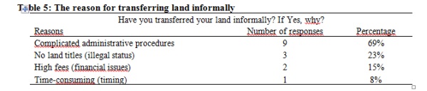
Of the participants who had transferred land informally, 69% stated
that the complicated administrative procedures as the main barrier,
while legal situation was the reason not doing registration of the 23%.
According to the Land Law, land users could only transfer land
officially providing that the land parcels have been issued LURCs
(Vietnam National Assembly, 2003). Time consumption was not accounted as
an issue to people as only one respondent accounted this as a reason
(Table 5).
There was also discussion on transferring rural land informally in
focus group discussions and it was suggested that if the land users
occupy and use land over a period of time, especially for agricultural
production in areas without new land planning projects, they do not
really need LURCs.
5.2 Support provided by Local Land Administration Authorities
Individuals and households were asked to evaluate the support of
local land administration authorities in specific land related services
and activities, included exchanging, transferring, inheriting,
mortgaging, leasing, sub-leasing, and guaranteeing land use rights, and
two common activities, applying for LURCs and land subdivisions.
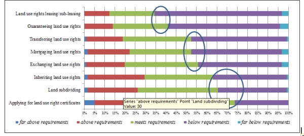
Figure 3: The evaluation of support of
government authorities and staff
Figure 3 describes the comparison of the satisfaction of land users
to the support of local land authorities and officers in different
services and activities. Overall, 55% of respondents were satisfied with
land administration services and activities. People evaluated highly
(74% and 66% acceptable) the support of local staff for applying for
LURCs and land subdivisions. . While the LURCs application activities
establish the initial legal framework to implement other rights under
land related services, the subdivisions of land parcels occur more often
in the rural and peri-urban areas due to the expansions of families and
urbanization process.
These results could be categorised into three groups. The most common
services and activities (an average of 67.5%) including inheritance of
land use rights (63%), subdivision of land parcels, and application for
LURCs received the significant support from local authorities and staff
(74%). The less common services (an average of 53.5%), including
transfer, exchange, and mortgage land use rights received the acceptable
support of local government offices such as land registration offices,
cadastral officers, and financial institutions, as well as heads of
villages, ranging between 52% and 56%. The service relating to less
common processes (an average of 37.7%), including guarantee by land use
right and lease, sub-lease of land use right, received the lowest
support of government agencies, with about 30% to 40% of respondents
satisfied.
On the other hand, there were 45% of respondents dissatisfied with
the delivery of land related services of local related authorities and
officers. Many evaluated the support of the local related staff and
authorities being below requirements (43%), and even far below their
requirements by the rest 2%.
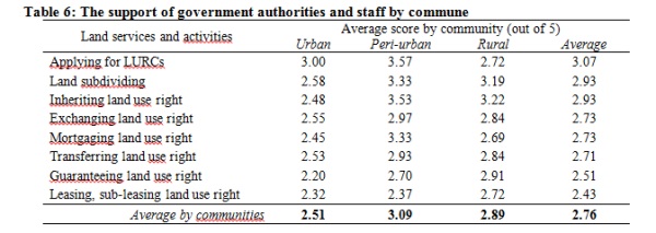
The results of questions on the quality of support provided by local
government authorities and staff were categorised by commune as shown in
Table 6. The scores were computed based on the participants’ responses
under a Likert scale ranging from ‘very poor’ to ‘very good’. Each
choice is given a numerical value and a mean figure for all the
responses is later computed. For example, in this case, a score of 1
relates to ’very poor’, 2 means ’poor’, 3 means ’fair’, 4 means ’good’,
and 5 means ’very good’ in support of government authorities and staff.
Overall, the support provided by local government authorities and
staff in rural and peri-urban areas were evaluated higher than for the
urban area, except for the process of ‘applying for LURCs’ in the rural
area. ’Applying for LURCs’ received the highest score in both urban
(3.00) and peri-urban (3.57) areas, with the support of government
authorities and staff for this service being evaluated as between fair
and good. On average, this service also received the best evaluation of
stakeholders across all three communities with an average score of 3.07.
The lowest evaluation was for the service ‘guaranteeing land use right
services’ in urban area (2.20) with the service receiving the lowest
score across all communes was ‘support for leasing, sub-leasing land use
right’ (2.43).
These results were confirmed, and the differences partly explained,
in the focus group discussions. In total, there were sixty comments
related to the support of local authorities and government staff from
the attendees. These can be summarised as follows:
- The support of local authorities and government staff was
evaluated highest for activities related to the ‘application for
LURCs’. There had been more than one-third of participants (22 out
of 60, equivalent to 37%) presented and shared experiences on the
support of local authorities and staff regarding the activities for
application for LURCs. Of these, 73% provided positive comments.
This was the largest number of comments on this topic;
- The support for conducting ‘land subdivision’ and ‘inheritance
of land use rights’ were positively evaluated by 18% and 13% of
participants respectively;
- The support for activities on ‘lease and sub-lease of land use
rights’ received just only one comment. This suggested that the
activities on leasing and subleasing land use rights at local level
were considered straightforward.
The urban focus group discussions confirmed that the support of
government authorities and staff for ‘applying for LURCs’ was the
highest. The three focus group discussions also confirmed that the
lowest level of support was considered to be for the sub-leasing service
being consistent with the result presented in Table 3.
6. ACCESSIBILITY TO LAND INFORMATION
6.1 The Importance of Land Information
Of 122 participants, 96% indicated that land-related information is
important to them. Of these 73% stated that the land related information
is essential in all aspects, including legal and policy information,
technical information, and administrative procedure information.
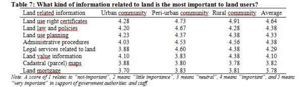
The information about LURCs was evaluated as the most important to
the land users, especially in rural and peri-urban areas with the scores
of 4.91 and 4.73 respectively (between ‘important’ and ‘very
important’). Information about LURCs includes land titling
implementation plans, administrative procedures, documents, and
supporting documents needed for applying for LURCs. On the other hand,
cadastral maps and sketches and information on land mortgage were
evaluated at the lowest levels of importance to land users with the
scores of 3.82 and 3.78 , respectively – between ‘neutral’ and
‘important’ (Table 7).
The related topics were discussed in all three focus group
discussions which found that these results reflected partly the demands
and understandings of local individuals and households on land
information. Participants, especially for those who living in rural and
peri-urban areas expressed the importance of land value information and
land use planning. The discussion suggested that more than half of
responses at the rural focus group discussion and about 70% of responses
at the peri-urban focus group discussion considered this information
most important to them for making decisions on land use. Participants
also considered that access to land plans, including land use planning
was difficult. Land value information is published under an
administrative decision of a committee without representing this
information on valuation maps. This lacks transparency and makes it hard
for citizens to access information on land values.
A minority of participants required cadastral maps and sketches as
well as land mortgage information. People living in areas covered by the
VLAP were provided technical land parcel sketches by surveyors during
the surveying period for verifying information related such as names,
boundary lengths, and parcel dimensions. They were asked to provide
feedback on the results of surveying for revision, and most focused on
land boundary marking and adjudication. This is one way the surveyors
and government agencies mobilising people to participate in land data
collection. However, individuals can often only verify information such
as names, addresses, and ID numbers. It is hard to verify the accuracy
of the parcel dimensions and areas. Nevertheless, this is a good process
for correction of data from the local stakeholders.
6.2 Accessibility of Land Information
The above section presented the evaluation of land users at
grassroots level on the importance of land information. The results show
that, despite the different responses, individuals and households have
significant demands for land related information. This section presents
the accessibility to land information and land documents by stakeholders
and also discusses the barriers that individuals and household faced (as
shown in Table 8).
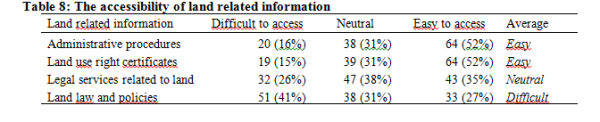
Access to land-related ‘administrative procedures’ and ‘LURCs’ were
easier than the other types of information. Over half of participants
(52%) acknowledged it was easy to access these two basic types of
information related to land. On the other hand, people at grassroots
level faced difficulty accessing information on ‘land law and policies’.
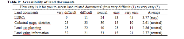
The results in Table 9 show that respondents found the ‘LURCs’ the
most accessible while the other documents are neither easy nor difficult
to access.
The result was confirmed by the outputs of focus group discussion
meetings based on the responses to the question about the difficulties
people experienced when participating in the government land
registration process. According to the discussion, about half of
attendees agreed that the best way to access land related information
for them was to approach the local authority officers. Some attendees
stated that they could access information by visiting public display
sites of local offices. The information they could find included the
list of qualified and disqualified applications for LURCs; information
on land fees and tax; information on compensation, support and
re-settlement plans (in some specific projects containing land
recovery).
Participants were also asked about the accessibility of land
documents including: LURCs, cadastral maps and parcel sketches, land use
planning maps and documents, and land valuation information. The result
shows that the accessibility to LURCs was evaluated as the easiest. This
is consistent with the results in Table 9.
Surprisingly, access to ‘cadastral maps and parcel sketches’ and
‘land use planning information’ were more difficult to access despite
the related legislation listing these as mandatory information needed to
be publicity accessed by stakeholders (Vietnam National Assembly, 2003).
At the focus group discussions, almost all participants revealed that
it was easy to find information about the LURCs. However, the
information about the ‘land use planning’ and the ‘legal dimensions’
(through the maps) of land parcels was hard to access. Some participants
advised that they found it difficult to get enough land use planning
information and documents when they want to buy more land.
Access to information and documents is an important indicator for
reducing rural poverty in developing countries (Binswanger-Mkhize,
Bourguignon, & Brink, 2009). Experiences from grassroots levels show
that the land disputes are often about land boundaries, and disputes can
be reduced through the cadastral survey, mapping and adjudication
process with the participation of land users and providing a clear
mechanism for accessing land related information and documents.
Limitations for accessing land information
An average of57% of participants indicated that they faced difficulty
in accessing land related information, mostly because of the information
was unavailable or out of date (both 71%). Complicated terminology and
high fee rates for accessing information were also barriers with 57% of
participants (Table 10).
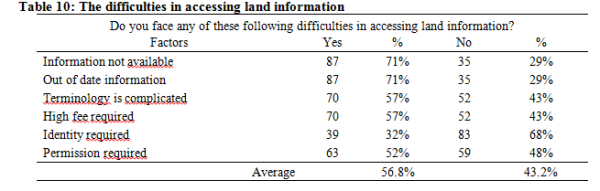
Even though the communal offices are responsible to make information
publicity available, landholders still face difficulty in all of aspects
of accessing land information: quality (out of date, complicated
terminology), quantity (not available), timing (out of date, not
available) and financial (high fees) manners.
The manual methods required to access land information and documents
and the roles of individuals have reduced the level of accessibility of
citizens to land information. This is one of the aims in the development
of an SDI Land proposed under the current research.
Dissemination of land information at grassroots level
There was uneven result among the methods of providing information
for citizens, including mass media such as television, radio, and
newspapers (both print and online versions) to local measurement
including village meetings, poster and leaflet. Table 11 compared the
evaluation of individuals on the effectiveness of the dissemination of
land information to citizens.

Surprisingly, the most difficult way to access land information was
through the Internet. Approximately half (47%) of the participants
indicated that it was hard to access land information by searching on
the Internet. Only 18% responded that they could easily do this via the
high-tech and speedy search engines. The figure again reflected the weak
dissemination of information about laws and regulations over the
Internet. According to the Law on Land, Law on Urban Planning, the
publication of information on land, such as urban planning (both draft
and approval ones) needed to be made mandatory on the Internet through
the websites of provincial people’s committees or relevant
organisations. This result consisted with the data showed in Table 10
with 71% of participants stating that out of date or unavailable
information made them unable to access suitable land information.
The focus group discussions also supported these figures and
information. The consultations suggested that the information which
people tried to search on the related websites through the popular
search engines include:
- Land related administrative procedures for applying for LURCs,
mortgaging LURCs for loans from commercial banks, selling or buying
land;
- Planning, land-use plans, urban planning both
maps and descriptions;
- Information about land recovery, compensation, and
resettlement, especially when a new plan is approved;
- Information on land leasing, renting and selling;
- Information on charges, fees and taxes related to land including
charges and fees for applying for LURCs, extracting cadastral maps,
extracting legal status of land parcels, land mortgaging, land
subdivisions.
In contrast, local village meetings were still the most effective
channel for people to find and seek information (4.06 – between ‘easy
and ‘very easy’), especially on land use planning and LURCs. The field
observations suggested that, similar to the other traditional villages
in the country, the heads of villages in the case study areas often
organised meetings (officially or unofficially), usually at nighttime to
gather villagers for the dissemination of information. In these
meetings, the villagers are provided with general information such as
land use planning, new project implementation plans, and land taxation
apart from the other information on the agricultural schedules.
7. DISCUSSION AND CONCLUSIONS
The above sections described the results of consultation with
grassroots stakeholders on their understanding of land administration
and their accessibility to land related information. The key findings of
these consultations can be summarized to include:
Firstly, the analysis shows that land use rights are significant to
grassroots stakeholders, both those with or without LURCs, and for both
male and female. The issuance of LURCs establishes the legal framework
to protect land tenure of the stakeholder at the highest level. LURCs
provide the legitimate and formal right to access to land.
Secondly, there is a significant demand from grassroots stakeholders
for land related information, in both spatial and attribute data
formats. The analysis suggests that the land information plays an
important role for landholders to make decisions. However, the
accessibility to land information still remains weak, especially for
spatial data (mapping), land use planning, and land value information.
According to the Land Law, information regarding administrative
procedures for land use certificates, cadastral maps, land use planning
and land value is mandatory published in a number of ways and forms for
citizens to access openly and freely. The land administration system
should ensure the information is available and updated with an
appropriate infrastructure for provision of information.
The analysis suggests limitations in land administration processes
have placed barriers to accessing land information. The reasons include
the unavailability of information, out of date information, complicated
terminology, high fee levels, and permission requests. In addition, the
use of the Internet to delivery land information has been ineffective
which suggests that and further development of SDI must recognize the
important role of the traditional village level sharing of information
in a variety of forms. However, the younger people will increasingly
look to the Internet for land information. By 2013, there had been more
than 31 million Internet users in Vietnam (MIC, 2013). The huge number
has been still rapidly increasing over the last few years and predicted
to be doubled in 2016. The figure shows the potential of information
provision on Internet is huge as websites can offer quick access to
information for stakeholders simply with a connection. On the other
hand, the related laws and regulations have already outlined the types
of information that must be published online or not online. In fact,
despite the rapid increase of number of the Internet subscribers in the
country, the usage of this technology for dissemination of land related
information has been still limited. Investment in an efficient
infrastructure such as a land portal would make the accessibility to
land information available and easy.
Thirdly, local government land authorities and staff should
be provided with ongoing training under ongoing capacity building
programs. In order to improve accessibility of government land
information to citizens, this should include customer service training
and improvements in efficiency. The benefit to the State is that this
may reduce the percentage of people who transfer land under informal
land markets, bringing them into the formal economy.
Lastly, public awareness rising campaigns should be
implemented more often to local stakeholders. Initially, individuals and
households need awareness of the importance of LURCs to ensure their
land tenure security. Land users should also be informed their rights,
restrictions and responsibilities fully to avoid social risks of
implementation of land use rights. For instance, participation in LURCs
process and land registration will reduce land disputes and complaints
which often happen at grassroots level. Traditional village level forums
continue to be important for awareness raising. At the higher level,
land users should be guided to seek and request land information they
need by using one-stop shop and the Internet via a land portal.
The paper describes the results of stakeholder consultations on
accessibility to land administration in case study areas. Participants
living in the study areas perceive that LURCs and related services are
the most important to protect their rights on land and understand their
land use rights competently. The demands of access to land, land
information, and land documents have been recently increasing. However,
the level of accessibility to land information still remains low. There
has existed an inefficient link among government agencies for accessing
and sharing data efficiently and effectively.
The results have included evaluations of limitations, and barriers
which could support to improve the land administration system, reform
land administrative procedures, raise awareness for local citizens, and
building capacity for government staff.
REFERENCES
Binswanger-Mkhize, H. P., Bourguignon, C., & Brink, R. v. d. (2009).
Agricultural Land Redistribution: Toward Greater Consensus: The World
Bank.
DEPOCEN, World Bank, UKAID, & VTP. (2014). Land Transparency Study:
Synthesis Report. Hanoi, Vietnam.
Embassy of Denmark, Embassy of Sweden,
& World Bank. (2011). Recognizing and Reducing Corruption Risks in Land
Management in Vietnam (Reference book). Hanoi, Vietnam: National
Political Publishing House.
FAO. (2012). Voluntary Guidelines on the Responsible Governance of
Tenure of Land, Fisheries and Forests in the Context of National Food
Security. Rome, Italy: FAO.
Malesky, E., Tuan, D. A., Thach, P. N., Ha, L. T., Lan, N. N., & Ha,
N. L. (2015). The 2014 Vietnam Provincial Competitiveness Index:
Measuring Economic Governance for Business Development. Hanoi, Vietnam:
Labour Publishing House.
Martini, M. (2012). Overview of corruption and anti-corruption in
Vietnam. U4 Expert Answer, 315.
Maxwell, D., & Wiebe, K. (1999). Land Tenure and Food Security:
Exploring Dynamic Linkages. Development and Change, 30(4), 825-849. doi:
10.1111/1467-7660.00139
MIC. (2013). Vietnam White Book on Information, Comminication and
Technology 2013. Hanoi, Vietnam: Information and Communication Punishing
House.
Muggenhuber, G. (2003). Spatial Information for Sustainable Resource
Management. International Federation of Surveyors: Article of the Month,
September 2003.
Quizon, A. B. (2013) Land Governance in Asia: Understanding the
debates on land tenure rights and land reforms in the Asian context.
Vol. 3. Land Governance in the 21st Century: framing the debate series.
Rome, Italy: The International Land Coalition.
Steudler, D., & Rajabifard, A. (Eds.). (2012). Spatially Enabled
Society. Copenhagen, Denmark: International Federation of Surveyors
(FIG).
Thu, T. T., & Perera, R. (2011). Consequences of the two-price system
for land in the land and housing market in Ho Chi Minh City, Vietnam.
Habitat International, 35(1), 30-39. doi:
10.1016/j.habitatint.2010.03.005
Vietnam National Assembly. (2003). Law on Land 2003. Hanoi, Vietnam.
Vietnam National Assembly. (2013a). The 2013 Consitution of the
Socialist Republic of Vietnam (adopted by National Assembly Term XXII at
its sixth Session on November 28, 2013). Hanoi, Vietnam.
Vietnam National Assembly. (2013b). Law on Land 2013. Hanoi, Vietnam.
Widman, M. (2014). Land Tenure Insecurity and Formalizing Land Rights
in Madagascar: A Gender Perspective on the Certification Program.
Feminist Economics, 20(1), 130-154. doi: 10.1080/13545701.2013.873136
World Bank. (2009). Vietnam Development Report 2010 - Modern
Institutions. Hanoi, Vietnam: Joint Donor Report to the Vietnam
Consultative Group Meeting (December 3-4, 2009).
World Bank. (2009). Vietnam Development Report 2010 - Modern
Institutions. Hanoi, Vietnam: Joint Donor Report to the Vietnam
Consultative Group Meeting (December 3-4, 2009).
World Bank. (2011). Report of the Study on National Spatial Data
Infrastructure Development Strategy for Vietnam. Hanoi: WB Joint Working
Group of the World Bank and Ministry of Natural Resources and
Environment.
World Bank, & Government Inspectorate of Vietnam. (2013). Corruption
from the Perspective of Citizens, Firms, and Public Officials - Results
of Sociological Surveys. Hanoi, Vietnam: National Political Publishing
House.
BIOGRAPHICAL NOTES
Mau Duc Ngo commenced his PhD study on SDI for land administration at
the School of Mathematical and Geospatial Sciences of RMIT University in
July 2012 as an Australia Development Scholarship (ADS) awardee. The
research investigates the development of SDI and aims to develop and
implement an SDI model for land sector in Vietnam to enable data
updating and sharing as well as access to land information by all
stakeholders. Mau has been working for the General Department of Land
Administration (Vietnam) since 2001. He holds a BSc in Land
Administration and a MEng in Urban Planning and Management.
David Mitchell is an Associate Professor at RMIT and a licensed
cadastral surveyor. He has a PhD in land administration. David is
co-chair of the GLTN Research and Training Cluster, and member of the
GLTN International Advisory Board. At RMIT University he teaches
cadastral surveying and land development and undertakes research
focusing on the development of effective land policy and land
administration tools to support tenure security, improved access to land
and pro-poor rural development. He also has a strong research focus on
land tenure, climate change and natural disasters.
Donald Grant was the New Zealand Surveyor General until February 2014
when he took up the position of Associate Professor in Geospatial
Science at RMIT University. He holds a BSc Honours in Physics from
Canterbury University, a Diploma in Surveying from Otago University and
a PhD in Surveying from the University of New South Wales. He registered
as a surveyor in 1979 and is currently registered as a Licensed
Cadastral Surveyor in Victoria.
Nicholas Chrisman was Head of Geospatial Disciplines at RMIT
University until December 2014. He is a Professor and holds a PhD in
Geography with more than forty years teaching experience at university
level. Currently, he is an editor for Journal of Cartography and
GIScience, published by Taylor & Francis. Nicholas has published two
books and over a hundred scientific articles. He is a member of Panel on
Developing Science, Technology, and Innovation Indicators for the
Future, National Research Council (USA).
CONTACTS
Mau Duc NGO
School of Mathematical and Geospatial Sciences
RMIT University
GPO Box 2476
Melbourne, Victoria 3001
Australia
Tel. +61 3 9925 1132 / Fax +61 3 9925 2454
Email: mauduc.ngo@rmit.edu.au @mauducngo
Web site: http://www.rmit.edu.au/mathsgeo
|