Article of the Month -
July 2012
|
3D Cadastre in the Federal Countries of Latin America
Diego Alfonso ERBA and Mario Andrés PIUMETTO, Argentina
1) This paper was presented
at the FIG Working Week 2012 in Rome Italy, and the main question asked
is: Is it realistic to develop spatial concepts for parcels and legal
land objects and to propose a 3D cadastral model in the federal
countries of Latin America at this time? The conclusion indicates that
this is the right time to start thinking about it, compiling the
legislation and systematizing the 2D definitions as a first step. Latin
America occupies approximately 15% of the Earth's land surface and
therefore a focus on this continent is appropriate. The next FIG
Regional Conference will therefore take place in Uruguay, 26-29 November
2012, with emphasis on the challenges of the region.
Key words: 3D Cadastre, Federal Countries Cadastre, Latin
America
SUMMARY
Latin America is a vast region of the world, occupying approximately
15% of the Earth's land surface. The 20 countries that compose it have
around 400 regional governments (states or provinces) and 16,000 local
governments. The region is characterized by a variety of races,
landscapes, languages and dialects, climates, history and political
systems, in which only 4 countries are governed under federalist
regimes. In this system the power is divided among the national,
regional and/or local governments, with Constitutions that define each
level´s attributions. Argentina, Brazil, Mexico and Venezuela, together,
have 65% of the region’s population and a similar percentage of surface
area of Latin America.
The concepts of parcels, their identification and description, the
extension of the properties, the restrictions of property rights, and
many other aspects related to the cadastre are different. This paper
compares the cadastral structure and the registration of land right in
the federal countries of Latin America, describes the main existing
legal land objects in the legislation, and provides a perspective for
implementation of a 3D Cadastral system for each of them, under the
legal vision.
1. INTRODUCTION
In most Latin American countries, the cadastral systems were created
under the orthodox physical-economic-legal models imported from Spain
and Portugal. In recent years, the multipurpose cadastral model has been
gaining acceptance in the region as a new alternative, better suited to
the needs of administrators and the public. The spread and gradual
implementation of Spatial Data Infrastructures (SDI) in the region is a
sign of the willingness to share data and investments among different
institutions.
The question that inspired this paper was: Is it realistic to develop
spatial concepts for parcels and legal land objects and to propose a 3D
cadastral model in the federal countries of Latin America at this time?
The conclusion indicates that this is the right time to start thinking
about it, compiling the legislation and systematizing the 2D definitions
as a first step.
2. CADASTRAL ORGANIZATION IN THE LATIN AMERICAN FEDERAL COUNTRIES
In
Argentina there is no single system, as the provinces never
delegated the cadastral function to the federal government. In fact, one
interesting feature of the Argentine system is that, although the
country has a National Cadastral Law and a Federal Cadastral Council
that establishes general guidelines, each federative body has its own
provincial cadastral law and specific regime. Therefore, the provinces
organize their territorial cadastres to identify the physical, economic
and legal aspects of the parcels, and use that data to define their land
tax policies. In parallel, some municipalities organize their urban
cadastres with the main goal of enforcing planning standards, mainly as
it pertains to the subdivision of land, and use that data to define the
service fees collection policies. The connection between the municipal
and provincial cadastres is made at different levels around the country.
In
Brazil, federalism has a particular connotation when it comes to
managing territorial information. While the rural cadastre is organized
by the National Institute of Colonization and Agrarian Reform, which is
part of the central government, and is therefore centralized (although
distributed around the country), local governments organize their
municipal cadastres with ample authority and independence, focusing
mainly on the cities. Given the enormous diversity of criteria, and as
an alternative for the municipalities that lack the needed human,
technical and financial resources, the Ministry of Cities has published
National Guidelines for the Creation of a Multipurpose Cadastre which –
although lacking the force of law – guide technical and administrative
personnel through cadastral restructuring.
In
Mexico, public information on real estate is obtained from
cadastres and registries. As there were inconsistencies in many cases,
some states decided to place both institutions under the same roof (in
some cases only “legally”, in others “physically”). Neither the Federal
Constitution nor any statute mandates a cadastral function. The
attributions given to municipalities by Art. 115 of the Carta Magna,
induced some local governments to set up cadastres, and so did at least
half the states in the country. Therefore, we can identify 3 basic
systems: The cadastres that are completely centralized at the state
level; the state cadastres that have been decentralized to the
municipalities; and the state cadastres that work in parallel with the
municipal cadastres. The social property created by the Mexican
revolution is managed by the National Agrarian Registry, which can be
considered a form of rural cadastral registry. The recent creation of
the Mexican Cadastral Institute (Instituto Mexicano de Catastro) and the
Mexican Society of Assessors and Cadastral Management Specialists
(Sociedad Mexicana de Especialistas en Valuación y Gestión Catastral)
opens up the possibility of establishing clear criteria and goals,
matched to the facts on the ground.
In
Venezuela, the Geography, Cartography and National Cadastral Law
establishes guidelines to restructure the country’s cadastres. According
to this law, Venezuela’s Simón Bolívar Geographic Institute directs,
coordinates and executes policies and plans for the creation and
maintenance of cadastres throughout the country, and Municipal Cadastral
Offices are obligated to organize their cadastre following these
national directives. Many times, the various limitations of local
governments to create and maintain a cadastre make this task impossible,
so the Institute provides support, mainly by developing joint projects
and collaborating to obtain resources from the pertinent public
agencies, without precluding the participation of the private sector.
Figure 1 shows a
comparison of the cadastral organization of the four federal countries.
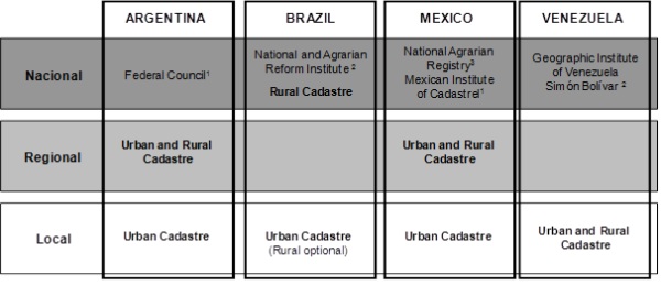
Figure 1
1consulting institutions, 2institutions with cadastral
functions 3 for social land property
3. PERSPECTIVES OF A 3D CADASTRE IN LATIN AMERICA
The conceptualization of a 3D cadastral model requires a clear
understanding of the physical occupancy of the territory and the current
legal framework. Regarding the urban aspect, the virtualization of the
different existing cities in the region is essential because it allows
us to analyze how 3D parcels can be defined, represented and described;
and how the 3D legal land objects restrict them.
This understanding is crucial to the development of a 3D structure for
the cadastres of the Latin American federal countries, and their
relationships with 3D land registries as well as the 3D land use
restrictions laws.
3.1 Virtual 3D Cities in Latin America
Among the different realities and technological levels of Latin American
countries, there are interesting experiences indicating that development
of 3D urban cadastral models in the region is possible in the median
term.
Entering the 3D world could start with the creation of different virtual
3D cities. In the context of this paper, a “virtual 3D” city is the real
(built) city which, represented geometrically, is useful in several
types of analyses, such as vehicular traffic studies, tracking of cell
phone waves, or any type of infrastructure network analysis. For other
kinds of analysis the virtual 3D city it is not sufficient, as when a
lawyer may need to visualize the legal 3D city as defined by urban and
environmental regulations. Figure 2 shows two virtual 3D cities, one
representing existing formal buildings and the other indicating the
legal city according to its development potential based on the
applicable urban regulations.
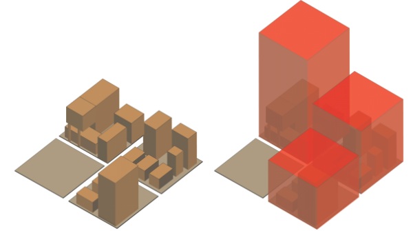
Figure 2 – Representations of the Virtual 3D
formal city and the Virtual 3d legal city
Note: The existing buildings on the left are incorporated into an
expanded legal city on the right. Source: prepared by Diego Erba and
Anamaria Gliesch-Leebmann.
In
Latin America, where the incidence of urban informality is practically a
constant in the urban landscape, it is important to visualize and define
the informal as well as the legal 3D virtual city. Every “occupied
space” is a part of the city and should be considered in the urban data
bases of the cadastre.
Informal settlements develop when people are unable to save money or
obtain access to credit to purchase a home or are ineligible to receive
government assistance through housing programs. They must find a place
to settle, which is often on hazardous or protected land that is
inappropriate for housing, or on vacant public or private land. The
magnitude of the need for housing often surpasses the amount of land
available, thus pushing informal settlers to build taller structures at
higher densities that in many ways are similar to those in the formal
housing market (figure 3).
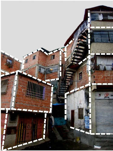
Figure 3 -
Improvised housing units in an informal settlement in Caracas, Venezuela
Source: © Martim Smolka; rendering by Diego Erba.
Urban properties and their surroundings are conditioned by different
kinds of restrictions described by legal land objects.
3.2 Legal Land Objects in the federal countries of
Latin America
The
concept of a land object arose with the “cadastre 2014” model as a piece
of land in which homogeneous conditions (normally defined by law) exist
within its boundaries. The definition affirms that if a law defines
phenomena, rights, or restrictions related to a fixed area or point of
the surface of the Earth, it defines a land object - LO.
Incorporating legal aspects, the concept was extended, to affirm that a
piece of land could be called a legal land object - LLO, when either a
private or a public law imposes identical juridical parameters. The laws
define the limits of a right or a restriction. The LLO normally is
defined by boundaries which demarcate where a right or a restriction
ends and where the next begins, and everything that right encompasses.
The
definitions are clear only for a 2D dimension connotation. Some examples
of the LLO mentioned in the document confirm this vision: private
property parcels; areas where traditional rights exist; administrative
units such as countries, states, districts, and municipalities; zones
for the protection of water and nature and for protection against
noise and pollution; land use zones; areas where the exploitation
of natural resources is allowed, etc.
The
construction of the 3D LLO concept can be based on the 2D definition,
and that is the reason why this study started identifying the legal
framework which describes the LLO in the federal countries.
It
is not common to find the terms LO or LLO in Latin American legislation.
In Argentina, the National Cadastral Law No. 26.209 defines “legal
object” as any portion of the territory that by nature and means of
access is finite and homogeneous. A “legal land object” (objeto
territorial legal) is one that is generated by a legal cause. This legal
cause may be a property title (as is the case in real estate
transactions), an ordinance or law (as is the case in ownership
restrictions, the creation of reservation areas, or the demarcation of
an urban area), or even an international treaty (such as those that
establish borders between countries). The law stipulates that all LLOs,
and their public records, must be managed by the provincial cadastres.
In
the rest of the Latin American countries, the definition of LLOs is not
as explicit as in Argentina, but proof of their existence can be seen in
substantive and ancillary legislation.
We
describe below 5 subject areas that meet the LLO definition in 4 Latin
American countries.
3.2.1
Environmental spaces and surroundings
In
Argentina, the National Law No. 25.509/2001 established a real
estate right to a forested area. It is conveyed separately from land
ownership, and allows somebody to plant in another parcel, but keep
ownership of what was planted. In addition, it allows for the purchase
of existing plantations in parcels that belong to others. This is a
temporary right, with a maximum duration of 50 years, and can be
canceled if it is not used for 3 or more years. This right is granted by
contract and must be recorded in the Registry of Deeds.
Argentina is the only country where glaciers can be found. The National
Law No. 26.639 of 2008 places restrictions for the conservation of
glaciers and the peri-glacial environment. Art. 3 creates a National
Glacier Inventory, with useful information to protect, control and
monitor glaciers. Art. 4 stipulates that the National Glacier Inventory
shall contain information about each glacier and its peri-glacial
environment classified by hydrologic watershed, location, area and
morphology. The inventory must be updated at least every 5 years, and
capture the changes in the glacier surface and its peri-glacial
environment. This last article stipulates, among others, the obligation
to measure the surface of the glacier and monitor it periodically to
determine any changes in its size. This law does not make any volumetric
references, even though it would be particularly interesting to study
changes in glaciers over time.
In
Brazil, the environmental legislation has a large scope. Two
areas are highlighted within the context of this work, which are still
defined under the 2D vision: legal reserve, and permanent protection
areas.
According to the Forestry Code (Act No. 4771/1965), a legal reserve is
an area located within a rural property or land, except for a permanent
protection area, which is necessary for the sustainable use of natural
resources, the conservation and restoration of ecological processes, the
conservation of biodiversity, and the preservation and protection of
native fauna and flora (section 1, §2º, III). Therefore, a legal reserve
is a portion of a rural property whose owner or possessor commits
him/herself to preserve the native vegetation. The vegetation of a legal
reserve cannot be eliminated, although the owner may use it under the
sustainable forestry management regime, as per the applicable legal
principles and technical-scientific criteria (section 16, §2º).
Permanent protection areas are protected by the Forestry Code. They may
or may not be covered by native vegetation, and have the environmental
function of preserving water resources, landscapes, geological
stability, biodiversity, and fauna and flora gene flows, as well as
protecting the soil, and securing the well-being of human populations
(section 1, §2º, II). These areas are characterized as such
regardless of their location, the use of the property or their
ownership, since they can be public or private properties. Some examples
of permanent protection areas are: the margins of any water courses (a
land portion varying from 30 meters to 500 meters); natural springs
(within a 50-meter radius); the top of hills, mountains and ranges; and
hillsides with over 45% slope.
In
Mexico, protection of environmental areas is governed by the laws
of “Environmental Equilibrium and Environmental Protection” and
“Sustainable Forest Development”. In both cases, the legislation imposes
no restrictions on property, nor does it establish special regimes for
forests or open spaces that limit property rights and are subject to
real registration. Nonetheless, both laws establish a broad set of
regulations and mechanisms related to zoning that contribute to regulate
use of these resources. For correct administration of this information,
it must be included in a spatial database as well as in the country’s
cadastral databases. An exception to this rule in the Federal District
(Mexico City) is the District Environmental Law, which establishes that
such restrictions must be registered in the Public Property Registry
(art. 98).
In
Venezuela, the Forest and Forestry Management Law (Decree
6070/2008) restricts the use of properties that have certain native
forests or are registered for forest use by the applicable authorities.
In no case are these considered unused or unproductive land, so no
compensation can be claimed, and they can only be expropriated in
exceptional cases. In addition, the law establishes “ecological
easements” in perpetuity over the parcels located in “protection zones”
and “forestry reserve areas,” as defined by the applicable authorities,
and the landowners are responsible for identifying these easements on
their land and recording them in their property titles. A special case
of ecological easement is the “protection zones of mountain and mesa
ranges”, which are strips of at least 300 meters on each side of
mountain ranges and inclined mesa slopes. (ref. art. 21, 22, 32, 33, 35,
39 a 42)
3.2.2 Water resources and
their surroundings
In
Argentina the restriction to private ownership around rivers is
established in Article 2639 of the Civil Code. This towpath is defined
as a 35 meter strip measured from the shore of navigable waterways
toward the interior of adjoining properties. No compensation can be
claimed for this area, and it implies a hands-off or non-interference
obligation.
In
Brazil, there are differences in the restrictions related to the
sea and the navigable lakes and rivers. The “terrenos de marinha” (Union
sea-land properties) are those areas which, washed by sea or navigable
river waters, reach up to 33 meters into the land, counted as from the
mean high water point. This point refers to the condition of the place
at the time of execution of section 51, §14 of the Act enacted on
11/15/1831 (section 13 of the Water Code, Executive Order No.
24.643/1934). These are public properties, i.e., such land portion is
not part of the private property. The “terrenos reservados” (reserved
lands) are those which possess navigable currents out of the reach of
tides, which reach a 15-meter distance, measured horizontally towards
the land from the median line of ordinary floods (section 14 of the
Water Code). Generally, the reserved lands on the shores of lakes and
navigable rivers belong to the states (Water Code – Executive Order
24,643/34, section 31), except when the river is owned by the Federal
Government, in which case the reserved land's title is owned by the
Union (section 31 of the Water Code, together with section 20, clause
III of the Federal Constitution). As in the case of Union sea-land
properties, reserved lands are not part of private properties.
In
Mexico, the “National Law on Water” complements Article 27 of the
Mexican Constitution on matters related to superficial or subsoil
national waters. The law foresees a towpath specifically called “Federal
Bank or Zone”, which must be 10 meters wide contiguous to the waterway,
measured horizontally from the maximum regular level of water. The
length of the federal bank or zone must be five meters in the river bed,
with a width no greater than five meters.
In
Venezuela, the Waterways Law, in its Article 6, stipulates that
all waterways, inland, marine or insular, superficial or underground,
are in the country’s public domain. Strips of land 80 meters on each
side of non-navigable or intermittent rivers, and 100 meters on each
side of navigable rivers, are also in the public domain.
The
same law stipulates that, because these waterways are in the public
domain, they cannot be part of the private domain of any physical or
legal person. Underground waters are in adjacent domains: the state owns
the resources, while a private party may own the land, its airspace and
subsoil, except for situations that can only be managed in 3D space.
Article 54 of this law attempts to protect the sensitive areas on which
the water, plants and wildlife depend for their existence and quality,
by declaring certain lands part of “protected zones of water bodies.”
These zones restrict the domain - with no right to compensation – in: a)
a surface defined by a circumference with a 300 m radius projected
horizontally and centered in the source of any waterway; and b) a 300 m
strip on either side of rivers, measured from the edge of the high water
mark; and from the borders of lakes and natural lagoons.
Figure 4 - Towpath
3.2.3 Underground spaces and concessions
In Argentina the
Mining Code was established by Decree No. 456 of 1997. It regulates the
property of mines, and the rights of exploration and operation. In Art.
7, it stipulates that the mines are private assets of the Federal
Government or the Provinces, depending on their location. Art. 10 of the
Mining Code stipulates that “independently of the original ownership by
the State… the private property of the mines can be established by legal
grant”. This granting of mining rights can be interpreted as a mining
easement to the mining company. On the other hand, Art. 12 defines the
mines as real estate properties. Art. 20 establishes a mining
cadastre to describe the physical, legal, and other useful information
about mining rights. Those rights are identified with points that
represent the vertices of the “area” defined in the requests for
exploration permits, discovery manifests, etc. However, the Mining Code
does not mandate in any of its articles the volumetric representation of
the mineral to be explored.
In
Brazil, according to the Federal Constitution, Article 176,
mining reserves, whether active or not, and other mineral resources and
the potential for hydroelectric power, are a type of property that is
different from the property of soil, for the purposes of exploitation or
use, and as such they belong to Brazil. However, the grantee has a right
to own the product that is mined from such area. Similar to the
Argentine Code, the Brazilian legislation does not provide any
information regarding volume.
In
Peru, mineral rights are established by Supreme Decree #014-92-EM
(Unified Text of the General Mining Act) and regulated by Supreme Decree
#03-94-EM. Section II of the Preliminary Title of this legislation
establishes that all mineral resources belong to the State, and that
this ownership is inviolable and inalienable. Act #26615 creates the
Mining Cadastre, whose unit of measure is the mineral right, a property
unlike land or the right of property under or over land, and therefore
is not the same as a parcel, as established in paragraphs 1 and 8 of
Article 885 of the Civil Code. The General Mining Act expressly states
in Article 9: “The concession of mining rights is a real estate property
distinct and separate from the parcel where said rights are located."
In
Mexico, Article 12 of the Mining Law refers to the “mining lot”
and describes is using elements that reveal it as more of a “mining
space”. According to the law, it is a solid body of undefined depth,
delimited by vertical planes and whose upper limit is the surface of the
Earth, based on which the corresponding perimeter is determined. The
sides that make up the perimeter of the lot must be oriented
astronomically both North-South and East-West, and the longitude of each
side must be in multiples of one hundred meters, except when these
conditions cannot be met because the lot meets other mining lots. The
location of the mining lot is determined based on a fixed point in the
lot, called the starting point and connected with the perimeter of or
located on the lot. The description affirms that the link of the
starting point will preferably be perpendicular to any of the sides
(North-South or East-West) of the lot’s perimeter. Despite the fact that
their descriptions are not georeferenced, mining spaces clearly have a
vertical development.
In
Venezuela, the Mining Law (Decree 295/1999) stipulates in Article
2 that mineral deposits of any kind belong to the country’s public
domain, and must be recorded in the Public Registry. The law describes
in detail how to distinguish the land from the subsoil where the mineral
deposits are stored; in its Article 10, it states: “for the purpose of
this Law, the earth’s crust is divided into two parts: the land, which
is the surface layer and the area below it affected by the work of the
landowner in activities other than mining; and the subsoil, which
extends indefinitely in depth from the point the land ends. The mining
activities in the subsoil do not generate compensation for the
landowner, except if they affect the land or other assets.” Article 26
defines an area of mining rights as “a pyramidal volume, whose base is a
rectangular horizontal plane measured in hectares, and whose vertices
and sides are oriented pursuant to a projection system adopted by a
competent authority”, and in Article 28: “the horizontal extension of
the mining rights shall be a rectangle defined by fixed points and
straight lines over the earth’s surface, whose surface unit is the
hectare (Ha.) Its vertical extension shall be defined by the projection
of this horizontal extension to the center of the Earth, with no depth
limit.
The right to explore and exploit mineral substances within the space
volume assigned constitutes a real estate right (Article 29) and must be
recorded in the Public Registry (Article 45).
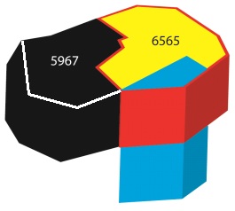
Figure 5 - Underground spaces
3.2.4
Aerial space and use restrictions
In
Argentina the Aeronautic Code was established by National Law No.
17.285 of 1967, and it describes the limitations to ownership of
property located close to airports. This Code defines the limits to
obstacles in the airspace in airports and their surrounding environment,
to ensure the secure landing and takeoff of aircraft. Although these
obstacles are by nature volumetric bodies, they are represented by their
surface projections on land. However, cross-sections are also enclosed
to describe the height over land over which the restriction extends.
In
Brazil the Law 7,565 of 1986 regulates the Air Code. The
restrictions to which neighboring properties of airports are
subject have to do with the use of such properties and the buildings,
premises, types of crops that can be farmed, and anything that may
hinder the operation of airplanes or cause interference to the radio
signals used to assist air traffic or block the visibility of visual
signs.
In
Mexico, the Civil Aviation Law, in Chapter 1 – General
Provisions, Article 1 – defines the use or exploitation of the airspace
over the national territory for the purpose of providing and developing
civil and government air transportation. The law states that the
airspace over the national territory is a general communication pathway
subject to the domain of the Federal Government. The Civil Aviation Law
regulations define the events that may occur in the airspace,
emphasizing the importance of a 3D definition.
In
Venezuela, the Civil Aeronautics Law of 2005 defines in its
Article 50 an “obstacle free surface” as the “slanted and horizontal
imaginary planes that extend over each airstrip or airport and its
surroundings, which can limit the height of the obstacles to airplane
circulation. The Aeronautic Authority shall establish in each case
obstacle free surfaces and the maximum height of construction and of any
other type of edification on the properties that, by their nature, may
present a potential risk to airline operations. These provisions
constitute another type of restriction to the property domain, a
geometric form that can be conveniently defined only in
three-dimensional space, and managed with a model with 3D
characteristics.
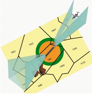
Figure 6 – Aerial space around airports
3.2.5 Urban restrictions
In Argentina these types of restrictions are established by municipal
ordinance and have the goal of fostering coexistence among neighbors,
improving the general welfare and ensuring public health. Some of the
salient features of urban restrictions are the obligation of
noninterference and the lack of compensation for the affected property
owner. Some examples are: chamfered corners (for visibility), building
setbacks, recess of common walls between buildings, land use
regulations, street extensions, etc.
In Brazil, the municipalities regulate the use of urban soil. Given that
the potential for development is defined by the municipality, the air
space in which buildings stand belong to the State, which then
represents a clear and distinct difference between a Right to Build and
a Right to Own Property. This is being discussed by scholars and by the
industries that develop land policy in Latin American cities, and it is
a clear example of the importance of our starting to see the city as an
accumulation of 3D plots on which there is the intersection of private
and public interests.
In Venezuela, the Land Master Plan Law (Ley de Ordenamiento Territorial)
and the Urban Master Plan Law (Ley de Ordenamiento Urbano) (1983 and
1987, respectively, in their Title V), establish that the regulations
derived from the land and urban master plans, drawn pursuant to those
laws by the respective applicable authorities (in particular,
municipalities) impose legal limitations (restrictions) to the property
rights, as they regulate their use and exploitation. In particular,
Article 6 of the Land Master Plan Law stipulates that the plans shall
define for each zone “… corresponding use and regimen, as well as the
definition of volumes and densities” of construction.
4. CONCLUSIONS
While the technologies used to measure, represent, and store information
are now evolving towards 3D platforms, urban legislation and land
policies continue to approach the city as a fat land surface.
To visualize the buildings and the restrictions imposed on properties in
3D is a considerable advancement for those responsible for urban
decision making. Nevertheless, there is a long way to go before 3D
information is integrated as part of urban legislation and property
titles. The consolidation of the 3D cadastre, which registers how 3D
parcels intersect with the corresponding legal norms and regulations,
would contribute to more effective urban and environmental planning,
infrastructure network design; and the prevention of informality by
permitting the construction of future scenarios showing the impact of
land policies in space. Changing the term “area” to “space” would be a
first step in giving urban and environmental legislation a 3D
connotation, and would be a simple and relevant way to start the process
of introducing the new paradigm. The structuring of a 3D property
registry is still under development, but when it is established
landowners will understand that they own cubic feet instead of square
feet.
Hand outs of presentation at FIG Working Week 2012 in Rome, Italy
REFERENCES
Erba, Diego A. (2008) El catastro territorial en América Latina y el
Caribe. 2008. Cambridge, MA, USA, 2008. ISBN 978-85-906701-3-1. pg. 415
Available at:
http://www.lincolninst.edu/pubs.
Carneiro, A; Erba, D. & Augusto, E. (2011). Preliminary Analysis of the
Possibilities for the Implementation of 3D Cadastre in Brazil.
Proceedings of the 2nd International Workshop on 3D Cadastre. Delft,
Netherlands. Available at:
http://3dcadastres2011.nl/.
Lagarda Lagarda Ignacio. (2009). El catastro. Ayuntamiento de
Hermosillo, Sonora, México.
AKNOWLEDGEMTNS
The authors thank these partners and colleagues in the development of
research and publications in this fled of knowledge: Anamaria
Gliesch-Leebmann, Design Concepts 4 You, Seeheim-Jugenheim, Germany;
Andrea F. T. Carneiro, Federal University of Pernambuco, Recife, Brazil;
Eduardo A. A. Augusto, Brazilian Land Registry Institute (IRIB), São
Paulo, Brazil; Ignacio Lagarda, independent consultant on Cadastres in
Mexico; Leonardo Ruiz consultant on Cadastres and GIS in Venezuela; and
Martim Smolka, director of the Program on Latin America and the
Caribbean at the Lincoln Institute of Land Policy.
BIOGRAPHICAL NOTES
Diego A. Erba
Land Surveyor Engineering (Universidad Nacional de Rosario, Argentina).
Master of Science in Remote Sensing (Universidade Federal de Santa
Maria, Rio Grande do Sul, Brazil) and Master of Science in Multipurpose
Cadastres (Universidade Federal de Santa Catarina, Florianópolis,
Brazil). Doctor in Surveying Sciences (Universidad Nacional de
Catamarca, Argentina). He did Post Doctoral research in GIS on Water
Bodies at the Natural Resource Center of Shiga University, Otsu, Japan
and on GIS for Urban Applications at Clark Labs- IDRISI, Clark
University, Massachusetts, USA. Currently, he is a Fellow at the Lincoln
Institute of Land Policy, where he coordinates Distance Education
Programs and manages research projects on cadastres and GIS topics.
Mario A. Piumetto
Land Surveyor (National University of Cordoba, Argentina). Postgraduate
studies in GIS, Remote Sensing and Cartography (University of Alcala de
Henares, Spain). Professor in the Masters in Environmental Engineering
at the National Technological University (2001-present) and in the
department of Labor Final race in Surveying Engineering, National
University of Cordoba (2008-present). Teaching Faculty in the Program
for Latin America and the Caribbean of the Lincoln Institute of Land
Policy (2005-present). He served as Director of the Municipal Cadastre
of Cordoba, Argentina, leading modernization projects in the areas of
Cartography and Land Valuations. Currently, he is a GIS specialist and
independent consultant.
CONTACTS
Diego A. Erba
Lincoln Institute of Land Policy
113 Brattle Street,
Cambridge, MA 02138-3400
USA
Tel +1 617-661-3016
FAX +1 617-661-7235
E-mail: derba@lincolninst.edu
Website: www.lincolninst.edu
Mario A. Piumetto
Universidad Nacional de Córdoba
Facultad de Ciencias Exactas, Físicas y Naturales
Av. Vélez Sarsfield 1.610 – Ciudad Universitaria
FCEFN – UNC – CP 5.000 - Córdoba - Argentina.
Argentina
Tel +54 351 485-5505
E-mail: mpiumetto@yahoo.com.ar
Website:
http://www.agrimensura.efn.uncor.edu/
 |