Article of the Month - March 2020
|
China’s Geospatial information industry fights
against COVID-19
Prosper Washaya & Minyi Li,
China
This article in .pdf-format
(11 pages)

The Authors: Prosper Washaya(right) & Minyi Li (Left), Deqing
iSpatial Co., Ltd, China
This article describes how geospatial information is
being used effectively in a crisis situation; in this case fighting the
COVID19 virus in China.
The world is fighting to contain the COVID-19
epidemic, caused by the SARS-CoV-2 virus and people are becoming more
and more anxious as the virus hits over 70 countries with numbers of
confirmed cases of infected people on the rise. The World Health
Organization (WHO) has emphasized on the need for countries to
“strengthen preparedness for all possible scenarios and ensure early
containment measures.”
In China, however, the number of confirmed cases has
been on decline. WHO has praised “China’s aggressive efforts to wrest
the epidemic under control” attributing this to the efforts that are
being made by the government, institutions and residents.
As the majority of the population in China are
staying indoors and taking preventative measures to help prevent the
spread of the virus, front line workers, doctors, nurses, law
enforcement etc., are risking their lives by exposing themselves to
potential infection.
At the same time, people from other professions are
doing their part; construction workers worked around the clock to build
Wuhan's 2500-bed makeshift hospitals in record time to admit patients
being treated for the virus.
China’s Secretary General Xi Jinping has said that
the fast spreading crisis is “a major test for China” and encouraged
people to work together to prevent and control the epidemic. The crisis
has indeed proved to be a major test for what China’s technology can do.
As global technology leaders, major Chinese
corporations like Alibaba, Tencent, and Huawei have harnessed the power
of technology by using high-tech equipment like Drones, Disinfecting
robots, high tech thermometers and Smart City Technologies.
Smart City technologies such as Geographic
information systems, Big Data, Artificial Intelligence and Internet of
Things (IoT), have played an essential role in the prevention and
control of COVID-19.
A smart city is a concept that uses technology to
improve governance, planning, management, and livability of a city by
gathering real-world, real-time data.
According to Academician Li Deren from Wuhan
University, smart city technologies are crucial in the fight against the
virus. The ability for institutions to collect, store and analyze
spatial information is vital if the prevention and control of the
COVD-19 is to be achieved.
In Zhejiang Province, in a geographic information
industry park that was started from scratch about ten years ago, and
where the Inaugural United Nations Geographic Information Congress was
successfully held in 2018, companies and institutions are currently
implementing the smart city concept to fight the virus.
Through the Smart City concept, geographic
information companies and institutions in China, working together with
the public, are making efforts to ensure the defeat of the virus through
Mapping, Navigation, Location-Based Service, and Remote Sensing.
Government departments and professional institutions have used this to
provide services such as epidemic monitoring and analysis and early
warning, population migration analysis, material security etc.
Mapping, Location Based Services (LBS) and positioning
During the crisis, mapping data associated with the
epidemic has been crucial, not only for institutions and decision
makers, but also for the general public. Maps showing locations of
confirmed COVD-19 cases are helping people understand the scale of the
epidemic in their locations.
Here are some efforts that have been made by using
mapping tools:
-
In February, Baidu maps introduced an “epidemic
map" feature for its Baidu Map app, which shows suspected and
confirmed corona virus cases in real time. Baidu’s “epidemic map”
feature also shows epidemic control measures, risk levels and latest
news on travel situations.
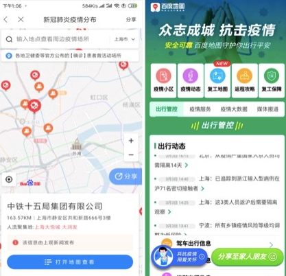
Fig. 1 Baidu maps “epidemic map” showing Corona
virus cases in real Time
-
The National Basic Geographic Information Center,
together with Skymap, developed a COVID-19 thematic map providing
national epidemic information, through interactive statistical
charts, visual maps and statistical charts together with a dynamic
timeline of changes of the situation.
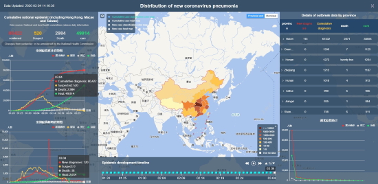
Fig. 2 COVID-19 thematic map developed by Skymap
and the National Basic Geographic Information Center
Cross-infections are major risk to, not only
frontline workers, but also members of the public. Therefore,
geo-information technology companies are using location-based services
to minimize the movement of workers collecting information relevant to
combating the virus.
Some companies have combined mapping with Location
Based Services to help reduce some of these setbacks:
-
Zhejiang Baijia Information Technology Co., Ltd
adopted Location Based Services through WEBGIS, cloud storage,
mobile Internet in the fight against the spread of
COVID-19.According to the general manager of the company "The
platform system has enabled interconnection and sharing of
information between command agencies, emergency response forces and
relevant disease control departments."
Fig. 3 Zhejiang Baijia Information
COVID-19 Webmap platform
-
China TOPRS Technology Co. Ltd, recently
developed a mini-program based on GIS mapping and positioning
technology. Mini-programs are lightweight apps that run inside
another app and don’t need to be downloaded or uploaded through an
Appstore. The company’s mini-program is meant for employees to
report daily basic information such as their current location,
physical condition of them and their family, their residential
address during the Chinese New Year, and their travel activities in
the past 15 days. According to the branch general manager, Liao
Ming, this information can be accessed and viewed by the employer in
real time. Liao Ming added that the software is set to expand
nationally.
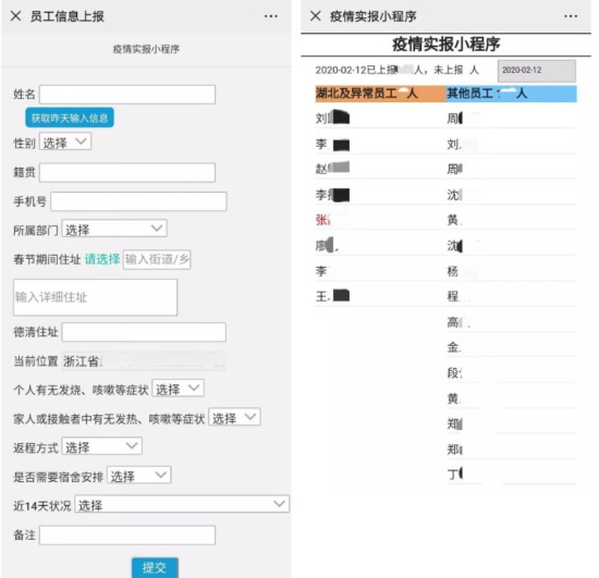
Fig. 4 Interface of China TOPRS Technology Co.
Ltd mini program for employee information
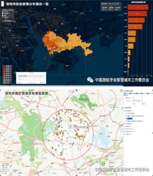
Fig. 5 Shenzhen Center for Disease Control and
Prevention’s GIS base system to display information about the
-
Cangqiong Digital launched an Epidemic Prevention
Management Information System combining Geoinformation Technologies
and IoTs. The system has since been linked to Huairou District’s
management system in Beijing.
-
E-commerce giant Alibaba through its Alipay
services, introduced the Alipay Health Code. The Alipay health code
system is being adopted nationally and assisting authorities to
allow people to engage in day to day activities without risking the
spread of the virus.
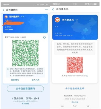
Fig. 6 Alipay’s Health Code system showing Grenn
and Red Codes respectively
-
Qianxun Location Network (Zhejiang) Co., Ltd.
provided Beidou high-precision positioning technology for Wuhan
Vulcan Mountain Hospital construction project, greatly improving the
efficiency of line measurement, and helped the Vulcan Mountain
Hospital’s early completion.
Artificial Intelligence and Big Data
In the information age, Big data and Artificial
intelligence have become ever the more important in situations similar
to the current COVID-19 outbreak. Here some institutions and companies
at the forefront of applying these technologies in the battle against
the virus:
-
Qianxun Location Network (Zhejiang) Co., Ltd.
combined geographic information, the Internet of Things and Big data
to adopt a warning alarm system. The system alerts officials when a
quarantined individual steps out of the quarantine zone.
-
Zhejiang Zhongdao Beidou Navigation Technology
Co., Ltd is using geographic information, AI and IOT to measure
temperature of residents at building complex entrances by installing
sensors such as infrared cameras making it possible to take daily
temperature readings for residents going in and out of premises.
-
Deqing Xidian Smart Technology Co., Ltd has
adopted facial recognition and verificationtechnologies through Big
Data and Artificial Intelligence technology. This has eased the work
load for workers collecting information by reducing the need for
manual work.

Fig. 7 Deqing Xidian Smart technology is using
facial recognition technology
-
Deqing iSpatial Co., Ltd (a subsidiary of Beijing
iSpatial Co., Ltd, FIG Corporate Member) developed the Information
Management System for people in public places. The system was
originally developed for tourism experience by allowing people to
add their personal information using NFC technology and their ID
cards to view tourist places. Now it has been upgraded to help fight
the epidemic by collecting Big Data and tracking people’s movements.
The system is installed in public places like shopping malls,
supermarkets, stations, cinemas, attractions, financial institutions
and other public places with large population mobility this has
greatly reduced the work load for community volunteers working
during the outbreak and avoid cross-infections. The system will be
upgraded and perform more functions in the post-epidemic period.
Fig. 8 iSpatial’s Information Management System
interface
Remote sensing
Remote sensing has proved to be an important tool in
the current fight against the virus. Remote sensing is a component of
Geoinformation technologies that involves obtaining information about
the dynamics of the earth using ground based, airborne and spaceborne
platforms, for example, cars, drones and satellites.
Some companies and institutions in China have adopted
remote sensing in monitoring the six-day construction of the Huoshenshan
and Leishenshan Hospitals in Wuhan:
-
The Gaofen-2 satellite was used to monitor the
construction of Huoshenshan hospital using multispectral imagery.
Changguang used the Jilin-2 multispectral Satellite for the same
purpose.
-
Zhuhai Orbita used the Zhuhai-1 hyperspectral
Satellite imagery to analyze the water environment around
Leishenshan Hospital
-
Changguang used Night-time remote Sensing from
the Jilin-1 satellite to confirm the construction of the Huoshenshan
and Leishenshan Hospitals in Wuhan.
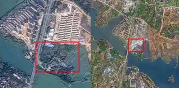
Fig. 9 Goafen-2 and Jilin-1 multisperctral
satellite images showing the construction site of the Houshenshan
hospital before and after construction.
Drone Technology
During the epidemic prevention and control campaign,
drones have become irreplaceable weapons and are playing a crucial role
in the fight through geographic mapping, logistics for distribution of
vital goods like food, face masks, medication etc., disinfecting
communities, and information publicity.
Companies such as Tencent, JD.com, ZhongtuXintu,
China AOPA, China Civil Aviation Emergency Rescue Alliance, Shenzhen
Keweitai, Chaotu Group, Tianjin Wanmao, Hebei Tianhai Surveying and
Mapping, Xi'an Geodetic Surveying and Mapping, etc, are members of China
Geographic Information Industry Association's drone application and
management committee and are currently taking advantage of drone
technology in the fight against COVID-19.
China's geographic information industry association,
states that as of February 12, 285 teams and more than 2,000
agricultural drones have participated in “disinfection operations”, and
disinfection of a total of 677 million square meters been completed in
14,903 villages and communities in 20 provinces across the country.
Other Institutions and companies have utilized drone
technologies in the fight against the virus in different ways:
-
XAG Co., Ltd. (one of the world's leading UAS
(Unmanned Aerial System) R&D manufacturers and a smart agriculture
solution provider) is using agricultural drones for epidemic
prevention and disinfecting purposes. According to experts, a drone
can spray and disinfect at least 1,800 acres of streets,
communities, and farms every day, and the efficiency is more than 50
times that of manual spraying.
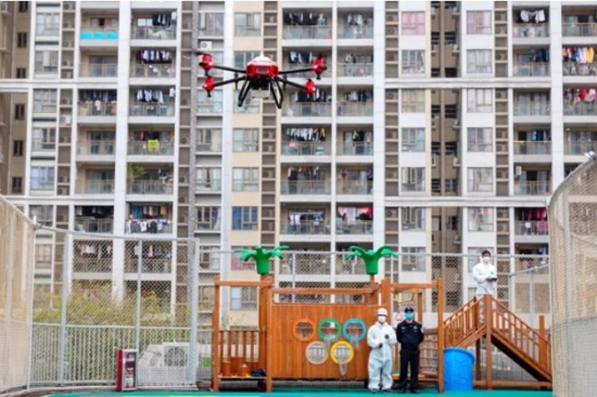
Fig. 10 Drone disinfecting a neighborhood.
Source: Economic Daily
-
DJI Agriculture are using drones for information
dissemination by using loud speakers attached on the drones to
communicate information to the public. The company equipped the
Jingwei M210 drone with a self-developed MP130 high-power megaphone
through the Payload SDK, with a volume as high as 130 decibels,
enabling passengers 300 meters away to clearly hear the broadcast
content.
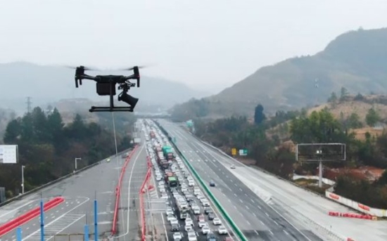
Fig. 11 Drone disinfecting a neighborhood.
Source: Economic Daily
-
In Hangzhou, Xunyi Network Technology Co., Ltd.,
is focused on the transportation of medical supplies to hospitals.
It has been found that this has decrease delivery time in half.
-
Zhejiang Zhongzhihuiyun Information Technology
Co. Ltd is using unmanned aerial vehicle high-definition videos to
conduct a large-scale patrol of Deqing city. They are also using
real-time image recognition to, accurately monitor and display the
number of people in specific locations. Mr Li Peihong, the general
manager of Zhongzhihuiyun, says that the technology has helped
people working on the front-line by reducing the need for manpower,
and thus reducing the risk of infection.
Fig. 12 Zhongzhihuiyun team carrying out
monitoring flights around Deqing City
GIS companies and institutions
Apart from their expertise, GIS companies have also
provided a helping hand to those affected by the epidemic. China’s
Ministry of Natural Resources reported that:
-
China Geographic Information Industry Association
donated to Hubei and waives annual membership fees in the province
and
-
Beijing Zeta Cloud Technology Co., Ltd., after
learning that Xi'an Public Health Center urgently needed servers,
switches and other information-based software and hardware
environments to support the hospital management system, immediately
deployed resources to overcome difficulties and provide emergency
support.
Organizations outside China
Outside China, Geoinformation Technology companies
have also been involved in the epidemic fight. Here are some examples;
-
Sentinel-1 imagery from the European Space Agency
(ESA) was adopted to perform deformation analysis of the Leishenshan
Hospital foundation using INSAR technology.
-
Imagery from the French Satellite, Pléiades, was
used to monitor work on the construction sites of the hospitals •
-
The Johns Hopkins University is currently
maintaining a website that tracks and maps the epidemic by gathering
information from multiple data sources.
-
ESRI, a leading organization in the
geoinformation industry is providing tutorials on how to responsibly
map the SARS-CoV-2
In one word, Geospatial information technology is
able to greatly contribute to the fight against COVID-19.


