Article of the
Month - February 2022
|
Development and Usability Testing of the
Participatory Urban Plan Monitoring Prototype for Indonesian Smart
Cities based on Digital Triplets
Agung INDRAJIT, Peter VAN OOSTEROM, Bastiaan VAN LOENEN, the
Netherlands
M. Hasannudin YUSA and Deni SUWARDHI, Indonesia
|
|
 |
 |
|
 |
| Agung Indrajit |
Peter van Oosterom |
Bastiaan van Loenen |
M. Hasannudin Yusa |
Deni Suwardhi |
This article in .pdf-format (27 pages)
This paper was part of the FIG
Working Week in 2021. It focuses on the development of an application
for participative monitoring of the implementation of urban plans which
is crucial to detect challenges and evaluate alternative scenarios for
intervention-making, achieving SDGs' targets and indicators.
SUMMARY
Sustainable Development Goals (SDGs) prescribed justice, strong
institutions, and partnerships to encourage citizens' participation and
inclusion. Goal 11 addresses urban areas: “Make cities and human
settlements inclusive, safe, resilient and sustainable.” The SDGs are
impossible to realize without the involvement of cities and
municipalities. They must align their land-use plans to align to SDG
indicators and measure their progress collaboratively. Therefore,
developing an application for participative monitoring of the
implementation of urban plans is crucial to detect challenges and
evaluate alternative scenarios for intervention-making, achieving SDGs'
targets and indicators. On the other hand, investments or disruption in
a city, either physical or non-physical forms, should change the
configuration of Rights, Restrictions, and Responsibilities (RRRs) on a
land parcel or 3D space. Therefore, monitoring the implementation of the
urban plan is required to gauge a city's progress towards fulfilling
SDGs indicators. In the digital transformation and democracy era, cities
may benefit from Geo-ICT to improve their capability to manage land
information and establish spatially enabled societies to fulfill land
management roles. The developments of application for Participatory
Urban Plan Monitoring (PUPM) presented in this article uses the proposed
Spatial Plan Information Package within ISO 19152:2012 on the Land
Administration Domain Model (LADM) revision. LADM is used to construct a
3D representation of restrictions and responsibilities from land-use
(urban) planning. This article presents the development of a web-based
application for PUPM with emphasis on the use of Digital Triplets by
adding legal spaces to Digital Twin. In supporting the PUPM of a city,
the two-way information flows are between authorities and local citizens
can be an updating system. An initial usability test is conducted in
order to improve PUPM further. From the usability test conducted, this
study found the potential of a two-way 3D spatial information flow to
support PUPM.
1. INTRODUCTION
The need for monitoring the implementation of the urban plan has
never been more critical. Murata (2004) demonstrates multidimensional
representation for urban planning processes, mainly to compare the
actual urban objects and urban plan. LeGates et al. (2009) and Batty &
Hudson-Smith (2012) argue that the combination of 3D representation and
innovation in Geo-ICT has the potential to assists stakeholders, both
authorities and local citizens, in managing their land and space. Cities
must collaborate with society in land management. The digital
transformation highlights the importance of a spatially enabled society
to exploit land information. A combination of multidimensional
representation and collaboration is believed to make a city and its
society smarter. Recently, Michael Batty (2018) proposed 3D city models
representing physical objects of a city and near real-time updating
system (i.e., sensors) as a digital twin of a city. This chapter
presents the development of 3D GIS that can perform two-way information
flow among stakeholders for supporting Participatory Urban Plan
Monitoring (PUPM). Also, this chapter introduces a digital triplets
terminology to represent legal objects in the urban area. Similar to the
digital twin, digital triplets use 3D representation and have updating
systems to continuously mirror an abstraction of legal situations of
objects in urban areas. Digital triplets shall accommodate a complete
view of the legal situation and consist of information about Rights,
Restrictions, and Responsibilities (RRRs) of an object (land parcel or
space) in urban areas from four land management functions (land tenure,
land valuation, land-use planning, and land development) (Enemark 2006
and Paasch et al. 2015). A participatory approach for urban monitoring
has the potential to update and compare digital twin and digital
triplets. This approach is taking the benefit of local citizens
reporting a change in the urban area. Moreover, it can be applied to
examine the conformance of the actual condition with prescribed legal
documents from land-use planning. However, this information should be
standardized as they correspond with the same reference, a
three-dimensional space.
This study considers the current policy and institutional rearrangement
of the Spatial Information Infrastructure (SII) in Indonesia,
transforming one-way data sharing and 2D to two-way collaborative and 3D
capabilities. Furthermore, this study provides a prototype of
participatory urban plan monitoring to develop two-way 3D information
flows on the Open SII platform. The output indicates that our framework
can support participatory urban plan monitoring in cities. This chapter
is concluded with a focus on the effectiveness and efficiency of a
two-way information flow for conducting urban plan monitoring involving
local citizens. This study presents the development of a prototype of 3D
Web GIS for PUPM. This prototype was designed to perform two-way
information flows among stakeholders, allowing local citizens to access
and contribute 3D spatial information for PUPM. This article presents
the first attempt to conceptualize the digital triplets concept from 3D
RRRs and develop a 3D user interface that enables two-way information
flows and 3D web visualization for supporting participatory urban plan
monitoring. Digital twins and digital triplets concepts depict the
condition of an urban area in a more realistic representation. Local
citizens can perform as a 'sensor' for digital twin and digital triplet.
This study also considers the ISO 19152:2012 on Land Administration
Domain Model (LADM) and national data governance policy to implement and
deploy the prototype on the current National Spatial Information
Infrastructure (SII) initiative. The proposed SP Package within LADM
revision is used to construct a 3D representation of RRRs from land-use
(urban) planning. This prototype is placed as part of the Indonesian
national Geoportal for highlighting its capability to handle 3D
visualization and two-way information flow.
2. PARTICIPATORY URBAN PLAN MONITORING IN INDONESIA
In 2016, the UN member countries adopted the “New Urban Agenda,”
a set of targets for cities to improve their planning practices and
urban management for sustainable growth. UN-Habitat (2015) published
“International Guidelines on Urban and Territorial Planning” to the
UN member countries for organizing urban planning. this guideline
recommends the local government “to set up multi-stakeholder monitoring,
evaluation, and accountability mechanisms to transparently evaluate the
plans' implementation and provide feedback and information on suitable
corrective actions.” According to this guideline, local governments
establish a participatory mechanism that facilitates the effective and
equitable involvement of stakeholders (including communities,
non-government organizations, and businesses) to monitor and evaluate
the implementation of urban plans. For this reason, Bappenas
(2018) updated the Indonesian national urban policy. This policy
attempts to handle uncontrolled land and space use and improve the
quality of citizens' participation in sustainable development. The local
government's inability and lack of citizens' involvement in monitoring,
evaluating and controlling land and space use cause urban sprawls, land
disputes, and illegal land use conversions in urban areas (Bappenas
2016).
Indonesia’s Spatial Planning Act prescribes monitoring the
implementation of the urban plan. Further, this Act mentions the
“conformance” approach that observes and examines real-world
implementations of the urban plans. The Spatial Planning Act allows
citizens to monitor, evaluate, and report any Spatial Planning Act
violations. The community's role in controlling land (and space) use is
regulated in Government Regulations (68/2010) on the Form and Procedure
for The Community’s Roles in Spatial Planning. This regulation affirms
openness as a core principle in monitoring the implementation of the
urban plan, particularly by mandating all levels of governments to
provide and share relevant data and respond to aspirations (including
local knowledge) from local citizens. Specifically, the Spatial Planning
Act instructs all governments' levels to develop and maintain an
information system and its dissemination system to monitor, evaluate,
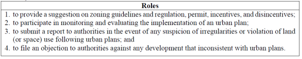
and report the implementation of urban plans to society. The roles of
the communities in land-use control are shown in Table 1. Moreover, this
regulation specifies the information that should be provided in such
spatial planning information system at the city level, which are: land
policies, urban plans, and spatial planning programs that have already,
being or will be implemented, as well as informational directives on
guidelines, provisions on zoning regulations, permits, incentives,
disincentives, and sanctions.
Table 1: Roles of the communities in land-use
control (Spatial Planning Act & Govt Regulation 68/2010)
Government Regulation (15/2010) on Implementation of Spatial Planning
prescribes a conformance approach in monitoring and evaluating the
implementation of urban plans. In 2017, the Ministry of Cadastre and
Spatial Planning released a Ministerial Regulation 15/2017 for providing
guidelines in monitoring and evaluating spatial planning. This
regulation only prescribes general documentation for monitoring and
evaluation of the implementation of the urban plan. Although this
regulation mentions the procedure for responding to reports from local
citizens, it does not explain the role of local citizens in monitoring
and evaluation. In the guidelines, monitoring activity is classified
into two types: direct and indirect observations. Spatial information is
used in both types of observations, while interviews are optional for
direct observation. Government Regulation 15/2010 prescribes eight types
of violations and eight types of infringements of land (and space)
utilization. Indrajit et al. (2019) provide workflows for monitoring the
implementation of an urban plan in Indonesia based on Government
Regulation 15/2010. This workflow includes local government,
communities, and non-government organizations as participants in urban
plan monitoring. The procedure begins by examining conformity with
zoning regulations. In the conformed case, the participant shall examine
each zoning's actual function according to the expected function stated
in zoning regulation. On the contrary, if participants find actual
conditions inconsistent with zoning regulation, they can identify
ecosystem threats (including safety, health, and environment).
Participants may submit reports to the authority to check the permit's
existence and validity over particular land (or space).
3. DIGITAL TRIPLETS FOR MONITORING IMPLEMENTATION OF AN URBAN PLAN
In 2014, the International Federation of Surveyors (FIG) launched
“Cadastre 2014 and Beyond”, the updated vision of Cadastre 2014, to
advocate the acceleration of registration of the complete legal
situations of land and space, including Rights, Restrictions, and
Responsibilities (RRRs) (Kaufmann & Steudler 1998 and Steudler 2014).
This updated vision also recommends a more robust data management
through standardization, data quality assessment, and facilitating
sharing of land information. Previously, Enemark (2006) proposes the
land management paradigm that cities can implement to manage urban areas
(and space) to put into good effect. This paradigm consists of four
interacting functions (land tenure, land valuation, land-use planning,
and land development) (Figure 1 and Table 2). This paradigm provides the
scope of Cadastre 2014 (Steudler 2014) and recommends cities to
standardize land information (Lemmen et al. 2019) and modernize their
Land Administration System (LAS) (Enemark 2006).
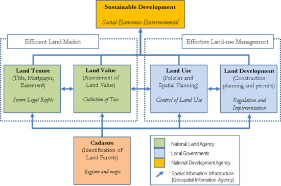
Figure 1. Actors and roles in
land management and SII in Indonesia (Source: Enemark & Sevatdal 1999
and Indrajit et al. 2020a)
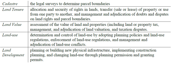
Table 2: Land management functions (Source: Enemark
& Sevatdal 1999).
A modern LAS should facilitate land-use control and land development
towards effective land-use management. In 2012, ISO published ISO
19152:2012 of Land Administration Domain Model (LADM) for providing a
guideline for countries and cities in establishing or improving their
LAS. Many countries implement LADM to improve data handling and add
‘machine-readability’ and ‘machine-actionability’ of land
information managed in their LAS (Van Oosterom & Lemmen 2015 and
Steudler 2014). Starting in 2019, LADM is undergoing revision and
improvement to modify existing core classes and add packages for land
valuation and land-use planning (Lemmen et al. 2019). Accommodating more
land management functions means adding more stakeholders to the land
administration process. It requires interoperability of information in
these functions and makes this information available and accessible for
land management practices. Cities are recommended to integrate LAS with
Spatial Information Infrastructure (SII) for land management as a step
forward to make land information accessible to all stakeholders
(including authorities, landowners, and economic actors). In the
manufacturing domain, Umeda et al. (2019) propose a Digital Triplets
concept as an extension of a digital twin to represent engineers and
technicians' knowledge and skill. Digital Triplets aim to support
engineers for crating values throughout the product life cycle from
physical, digital, and intelligence activity in the industrial field.
This article attempts to implement a city's digital triples by
constructing physical, digital, and legal situations of urban objects
(see Figure 2).
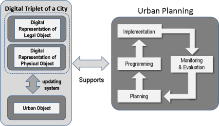
Figure 2. Digital Triplet of a
City. Adapted from McLoughlin 1969 and Umeda et al. 2019.
3.1 Representing 3D RRRs from land-use plan
In 2006, the Committee on Support for Thinking Spatially in the US
defined spatial thinking as “a constructive amalgam of concepts of
space, tools of representation, and reasoning processes” (NRC
2006). The concept of space consists of knowledge, skills, and habits of
mind. Spatial thinking enables description, explanation, and discussion
of the Spatio-temporal process, including functions, structures,
relationships, and operations in a city (NRC 2006). A suitable
representation will improve stakeholders' insights and reasoning in
presenting activity or phenomena (NRC 1997). The quality of decisions
impacting humans and the environment can be achieved through information
in higher resolution and dimensions (Kuhn 2005) that provides a more
realistic view of a city's complex setting (Roche 2014). Urban planning
departments have been widely using 3D city models for the past two
decades (Ranzier & Gleixner 1997). These models contain various urban
objects (i.e., buildings, trees, roads, pipelines, cables, water
bodies). Murata (2004) demonstrates the potential of 3D spatial
information for urban planning, such as: to visualize regulations in a
complex urban setting, to compare the actual urban objects (e.g.,
building, public facilities) with regulation, to construct a simulation
of the proposed urban development plans, and to facilitate
consensus-building between stakeholders.
Frank et al. (2012) highlighted the usefulness of integrating RRRs
from private and public laws and the need to have a 3D representation
for a complete view of the legal situation of land parcels of urban
space. The use of 3D city models is mainly for representing a snapshot
of physical objects in urban areas. In comparison, Batty (2018) argues
that a city needs to have a digital twin, a digital coupling of a city
with a near real-time updating system. The digital twin concept is still
emerging. This concept was developed in the manufacturing industry using
a 3D model with actual dimensions and location (Grieves 2014). It
consists of three parts: the physical object in real space, virtual
representation in virtual space, and connecting tools between the
physical object and virtual representation. Batty (2018) adopts this
concept for cities and expects the birth of other digital couplings to
model various abstraction in 3D representation. For example, planners
and authorities develop criteria (privileges, prohibitions, and
obligations) in the urban plan, translated into Rights, Restrictions,
and Responsibilities (RRRs) to 3D space. However, the contemporary
land-use plan exploits 2D visualization, while a complex urban setting
is better represented in 3D to accommodate criteria constructed in urban
planning (Indrajit et al. 2020). The 3D shape of a land-use (urban) plan
depends on the regulatory system in a country. The height or depth
dimension may be imposed for expected behavior to be performed by all
actors in space, including an activity or rights (permission),
restrictions (prohibitions), and responsibilities (obligations).
The International Organization for Standardization (ISO) published
19152:2012 on Land Administration Domain Model (LADM) standard to
provide a model-driven architecture and a shared ontology needed by
developing an effective cadastral system (Lemmen et al. 2015). The LADM
working group is developing the Spatial Plan Information Package (SP
Package) within the revision of ISO 19152:2012 (Lemmen et al. 2019).
This package contains three core classes: SP_PlanBlock, SP_PlanGroup,
and SP_PlanUnit (see Indrajit et al. 2020). SP_PlanBlock
and SP_PlanUnit contain geometry and legal expression derived
from the land-use (urban) planning process. LADM standard assigns RRRs
information into three subclasses: LA_Right, LA_Restriction,
and LA_Responsibility as administrative sources. The current
LADM standard also provides LA_BoundaryFace class to construct
a 3D representation of RRRs (ISO 2012). Representing Digital Triplets
requires more than just geometrical models. They should manage semantic
and topological aspects to represent urban objects for thematic queries
and further analysis (Gröger et al. 2012). The Open Geospatial
Consortium (OGC) published the CityGML standard to provide a
foundation on geometry, semantics, visualization of objects, and
semantics (Kolbe 2009 and Gröger & Plümer 2012). CityGML is an
open-source database schema that stores objects and attributes in a
hierarchical structure using Geography Markup Language (GML). Many
cities implement CityGML for managing their 3D city models
(Biljecki et al. 2015). CityGML consists of twelve core
modules: Appearance, Bridge, Building, CityFurniture,
CityObjectGroup, LandUse, Relief, Transportation, Tunnel, Vegetation,
Waterbody, and Generics. This format can only store all
objects into a linear geometry structure. These core modules are
supported in the 3DCityDB database system (Yao et al. 2018) with many
real-life implementations. The 3DCityDB is an open-source database
schema and a set of tools to import, manage, analyze, visualize, and
export 3D spatial information (Kolbe et al. 2019). In 3DCityDB, a
homogenous city object (i.e., building) shall be represented precisely
as one object.
Although the CityGML standard's initial intention is to
manage and exchange 3D city models, it can also publish 3D spatial
information to the web. 3DCityDB currently provides several 3D
visualization options for users to publish CityGML data, such
as Google’s KML (Keyhole Markup Language), COLLADA, and
glTF formats. Publishing or exchanging the 3D city model directly
in CityGML format is inefficient and requires suitable
client-side plug-ins (Ohori et al. 2018). Many web technology options
available for cities to publish their 3D spatial information as virtual
3D visualization over the Internet, such as OpenLayers 3.0
(www.openlayers.org), WebGL Earth (www.webglearth.org),
OpenWebGlobe (www.github.com/OpenWebGlobe), and Cesium
(www.cesium.com). Cesium technology is an open-sourced software that
enables users to explore 3D spatial information on a web browser without
any installation. Many cities combine CesiumJS with
3DCityDB (Yao et al. 2018) for its high-performance, ‘mashups’ and
cross-platform visualization capabilities (Prandi et al. 2015).
CityGML has a LandUse object model representing the 2D
surface assigned for planned land use (see Gröger et al. 2012). Digital
triplets can be in the form of buildable area (or space), 3D (space)
parcel, or 3D mining rights. The granularity of digital twin and digital
triplets follows the Level of Detail (LOD) proposed by the Open
Geospatial Consortium (OGC). Biljecki (2017) defines LOD as “an
indication of how thoroughly a 3D city model has been modeled and as the
degree of its adherence to its corresponding subset of reality".
LOD is classified into five grades based on visualization, accuracies,
and minimal dimensions of objects (OGC 2006). OGC includes LOD types
within CityGML standards to represent the city’s objects in
three multidimensional formats.
3.2 Updating mechanism: citizens as urban sensors in urban plan
monitoring
Today’s cities are using spatial information for various applications
and analyses. Moreover, Geo-ICT is proven to improve society’s ability
to plan and manage urban areas and making a city smarter (Batty et al.
2012, Daniel & Doran 2013 and Roche 2014). 3D representation and Geo-ICT
and its combination are considered as enablement to open ample
opportunities for cities to manage their land (and space) (LeGates et
al. 2009 and Batty 2018). If this combination is shared with relevant
stakeholders, it will improve the spatial thinking and cognitive ability
needed to plan and manage a city (Roche 2014 & 2017). Since the last
decade, citizens' ability to use spatial representation to monitor their
livelihoods improves (Arsanjani et al. 2015, Crooks et al. 2015, and
Herfort et al. 2019). In 2007, Michael Goodchild introduced "citizens as
sensors" terminology for an alternative source of mapping. Participatory
mapping gains popularity among local citizens in many countries,
facilitating their local knowledge to a map (Goodchild 2007). They are
provided with reference maps (or imagery) and tools to contribute
spatial information to the participatory urban monitoring system.
Minang & McCall (2006) define Local Spatial Knowledge (LSK) as local
knowledge generated by local citizens that offering a unique description
of land or space. In 2008, Sarah Elwood stressed that citizens require
land information to contribute local knowledge (Elwood 2008). In the
participatory approach, sharing (land) information to all participants
would be the foundation of a participatory approach and influential to
the quality of participation contributed to the initiative (Arnstein
1969 and Wilcox 1994). Later, Goodchild (2009) introduced the term
“Neogeography” for alternate map-producing techniques from
crowdsources, contributors other than experts and professionals. He
classified Volunteered Geographic Information (VGI) as maps produced
from Neogeographers using advanced Geo-ICT innovations, such as
mobile mappers and unmanned aerial mapping systems. There are success
stories of cities organizing a facilitated VGI, using web mapping
interfaces to allow local citizens, individually or in groups, to
contribute local knowledge in the form of a map with a predefined set of
criteria to a specific geographical extent (see Seeger 2008). Local
citizens are the custodian of Local Spatial Knowledge (LSK) as they hold
local knowledge of physical objects or phenomena that scientist and
professionals do not (McCall & Dunn 2011). However, they need certain
spatial information used as reference and tools to contribute their LSK
on maps for maintaining preciseness, including in Participatory Urban
Plan Monitoring (PUPM). Therefore, the existing SII should be improved
to enable two-way information flow among stakeholders and manage and
disseminate multidimensional spatial information. This chapter presents
the development of a user interface built on an open spatial data
sharing for PUPM using the proposed SP Package of LADM revision.
In participatory urban plan monitoring, the quality of information
flows should be carefully designed and managed. This chapter follows the
quality of the information flows concept proposed by Gudowsky & Berthold
(2013) for developing open participation in the SII. The concept of
quality of information flows is classified into four classes: one-way
and two-ways, depending on the recipient’s understanding, media, and
timing of the data. The one-way flow consists of uni-directional
and bi-directional dimensions. The one-way
information flow among stakeholders can be found in most SII, where
topographic maps are published as open data to a broader community.
Uni-directional is the most commonly used in sharing the map with
no right for citizens to negotiate. Simultaneously, the
bi-directional flow is two reciprocal uni-directional
flows without obligation to consider information from the other side. In
contrast, a two-way information flow has two types:
discussion and dialog (Gudowsky & Berthold 2013).
Discussion allows spatial information sharing to meet a consensus
through arguments or constructive disagreement. Dialog enables
stakeholders to experience the free flow of information to improve
understanding of the specific topic. Open participation requires two-way
flows where information exchange has more intensity between stakeholders
in discussion or dialog.
4. CONSTRUCTING 3D URBAN PLAN FOR INDONESIAN CITIES
In the Indonesian regulatory system, urban areas are divided into
zones of spatial designation depicted in the urban plan map. Local
governments use zoning regulations to ensure quality land or space
functions, minimize unintended land or space utilization, and preserve
the environment. In each zone, specific restrictions and
responsibilities are imposed to regulate location, activities, land-use
intensity, and building code. Land-use (urban) plans are used as a
reference for controlling land or space utilization, granting land or
space utilization permits (including air and underground utilization
rights developments), determining incentives, imposing sanctions, and
providing technical guidance in urban development. The spatial Planning
Act commands Indonesian cities to develop zoning regulations for
determining basic rules and techniques for zoning arrangements.
Basic rules constitute requirements for spatial use, including
conditions for activities, land use criteria, land-use intensity,
building codes, provision of necessary infrastructure and public
facilities, special regulations, technical standards, and implementation
guidelines. The Techniques for Zoning Regulation (TZR) were implemented
in Indonesian cities to allow flexibility in applying zoning rules. TZR
is also helpful in overcoming various problems in implementing necessary
zoning regulations, taking into account the contextual conditions of the
area and the direction of spatial planning (Ministry of Cadastre and
Spatial Planning Regulation 2018). TZR consists of Transfer Development
Right (TDR), Zoning Bonus, Conditional Uses, Performance Zone, Fiscal
Zone, Development Agreement, Overlay, Threshold Zone, Flood Zone,
Special TZR, Growth Control, and Preservation of Cultural Heritage. The
Ministerial or technical regulations are also considering multiple
aspects for height limitation. For example, the Minister of Cadastre and
Spatial Planning Regulation (2018) provides a guideline on setting the
limit of the height of high-density vertical housing areas to 40 meters.
While for landed high-density housing areas, it is only 10 meters
allowed by this regulation. It is measured from the ground to the
maximum distance of the roof. For other zoning types, authorities apply
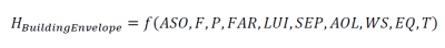
the height limitation (H_BuildingEnvelope) for each lot depending on its
zoning type. It considers Air Safety Operation (ASO), Fire hazards (F),
Property’s optimal prices (P), Floor Area Ratio (FAR), Land Use
Intensity (LUI), Sky Exposure Plane (SEP), Angle of Light (AOL), Wind
speed (WS), Earthquake (EQ), and Transportation (T). Thus, the third
dimension of a building envelope can be determined as follow:
On the type of land function, each allotment contains a set of zoning
requirements. These requirements may be represented with a 3D RRRs
object with dimensional requirements (i.e., maximum building heights,
ground-floor area coefficient, total-floor area coefficient, free
distance limit, and borderline distances).
5. A WEB-APPLICATION FOR PARTICIPATORY URBAN PLAN MONITORING
In 2020, the Indonesian parliament passed the Cipta Kerja
(Job Creation) Act, often called the Omnibus Law. 3D cadastre is
included and highlighted in this Act by assigning rights for Hak
Guna Bangunan (rights to utilize construction), Hak Pakai
(rights to use), or Hak Pengelolaan (rights to manage) in space
above, on, or below the surface. The Job Creation Act transforms RRRs
from 2D to 3D representation by specifying land use for below, on, or
above the surface and governing rights of access for utilities (i.e.,
cables) over or below land or space. The volumetric (height and depth)
limitation of land rights (rights of space) is introduced explicitly by
including maximum building heights, ground-floor area coefficient,
total-floor area coefficient, free distance limit, and borderline
distances into 3D RRRs. Moreover, this Act puts more burden on an urban
plan as it accommodates environment impact assessment and building code
into Rencana Detil Tata Ruang (RDTR) (detailed urban plan).
Consequently, Indonesian cities need to develop 3D RRRs consisting of
the four functions of land management (land tenure and cadastre, land
value, land-use, and land development, see Enemark 2006). In 2018, GOI
launched the Online Single Submission (OSS), an online platform
connecting various sectors to issue permits and business licensing and
investment at all government levels (Ministry of Trade 2018). The OSS
functions as a single national gateway for issuing permits and business
licensing. Therefore, 3D RRRs should be the core data in a permit
system, such as the OSS. The spatial plan information package from the
revision of ISO 19152:2012 has the potential to provide a foundation for
standardizing urban plan information and zoning regulations to be used
for the OSS. New guidelines for implementing technical aspects of the
Spatial Planning Act are provided by the Ministry of Cadastre and
Spatial Planning Ministerial Regulation 14/2020 on Guidelines on
Development of Spatial Planning Database (DSPD). The ministerial
regulation contains guidelines on DSPD to ensure information
interoperability and consistency of the land-use plan. It provides
standardization of the spatial plan feature class, including format,
storage structure, the naming convention for a spatial plan, and
detailed spatial plan (urban plan). This guideline mentions geometric
aspects in limited aspects, covering 1D (point) and 2D (line and
polygon) primitives. It still has not provided 3D primitives that
regulations and smart cities demand.
5.1 Workflow for Participatory Urban Plan Monitoring (PUPM)
application
Based on Government Regulation (68/2010) on the Form and Procedure
for the Community’s Roles in Spatial Planning, this study develops a
workflow that allows citizens to participate in urban plan monitoring.
The workflow determined for roles for performing tasks stated in Table
3: End-Users, Contributors, Contributors-Geometry, and Validators. This
workflow enables all types of stakeholders identified in Table 5to
perform roles assigned for participatory urban plan monitoring. This
study uses the existing urban plans of Jakarta and Bandung City that
implement height (and depth) thresholds to construct a volumetric form
of 3D RRRs. This study also includes 3D city models of these cities to
improve the spatial thinking of all stakeholders. With 3D RRRs and 3D
city models, the PUPM application constructs digital twin and digital
triplets of Jakarta and Bandung and enables all stakeholders to
virtually monitor urban plans. The PUPM application can be accessed
through https://tanahair.indonesia.go.id/pupm. This study constructs
PUPM workflow to enable two-way information flow, facilitating data
collection and consensus-building between contributors and validators to
collect and verify LSK on the implementation of the urban plan. This
activity can be attained through (1) accessing 3D city models (digital
twin) and 3D RRRs (digital triplets), (2) comparing actual conditions
with 3D RRRs by updating land (or space) functions, and (3) modifying
the existing 3D city models with updated (and more realistic) records
with multimedia files (Figure 3).
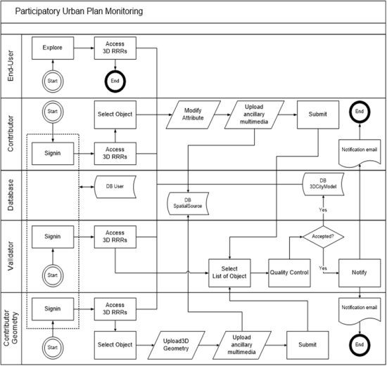
Figure 3. The Workflow of the
PUPM application
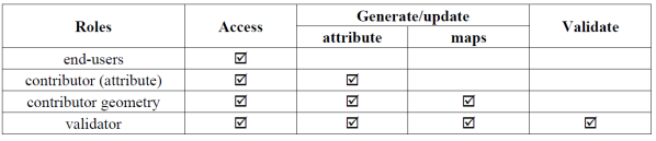
The PUPM application involves four roles in urban plan monitoring:
contributor geometry, validator, database, contributor (attribute), and
end-users (see Table 3). The four roles determined in this study are to
accommodate the roles prescribed on Government regulation (68/2010).
Contributors and geometric contributors can modify attributes and upload
a 3D file with a multimedia file as a supporting confirmation. Both
contributors then submit these files to the PUPM system. A web-based
application was developed to support monitoring the implementation of an
urban plan that allows participants to access 3D urban plans and
contribute 3D building with land (or space) actual utilization. The
workflow is using the “conformance” approach that compares actual
conditions with urban plans. Local citizens may follow the workflow to
monitor and report the urban plan infringements.
Table 3: Roles and privileges in participatory urban
plan monitoring
5.2 The spatial database for 3D RRRs from urban plans
Urban plan in Indonesia is governed by public law that consists of
Rights, Restrictions, and Responsibilities (RRRs) prescribed in a zoning
regulation for each zone. Currently, Jakarta and Bandung are still
managing urban planning with 2D representation and not complying with
the newly enacted guideline from the Ministry of Spatial Planning
Regulation (2020). On the other hand, the Job Creation Act requires 4D
topology, a 3D geometric representation with temporal managed as an
attribute of urban plans to support the permit system. The OSS system
also prescribes standardization to ensure machine-readability
and machine-actionability for all data, including urban plans. However,
Jakarta and Bandung have not standardized their urban plan according to
current national or international standards. Therefore, this study
includes construction 3D representation and information interoperability
to comply with the newly enacted guideline from the Ministry of Spatial
Planning Regulation (2020) for Jakarta and Bandung's urban plans and the
proposed SP Package LADM. This study includes versioning capability to
urban plan database to enable comparison or monitoring and evaluation
tasks in participatory urban plan monitoring. The height dimension is
sourced from the zoning regulation or ‘building envelope’ of
each zone. The height value is computed and enforced by local
governments using algorithm 1 in Section 4. This study implements the SP
Package as part of the revision of ISO 19152 on LADM for ensuring
interoperability between land management information, specifically
SP_PlanUnit and SP_PlanBlock classes and its code lists.
The core LADM data models and code lists are applied to manage common
land management information. LA_BoundaryFace class of LADM was
used to construct a 3D representation of urban plans for Jakarta and
Bandung City. Implementing the SP Package on Jakarta and Bandung urban
plans could be done smoothly. These maps contain height limitation
parameters and have sufficient quality in geometric, logical
consistency, and semantics. These urban plans are developed upon
large-scale topographic maps (1:1000 and 1:5000) but apply their
semantics standards.
The 3D spatial representation of urban plans is transformed into
CityGML standards using Feature Manipulation Engine (FME)®
of Safe Software before being loaded into the 3DCityDB
database. Two actual urban plan of Jakarta and Bandung city is stored in
3DCityDB in CityGML format for supporting the PUPM
application. These urban plans are then converted to a 3D tileset using
a batched 3D model (b3dm) format for faster interaction at the
client-side. The PUPM application prototype provides a minimal
topography map published from global map services for adding locational
context and spatial references for its users. The 3D database was
designed to allow contributors to upload their building data. This study
applies a non-linear geometry to comply with all possible shapes
commonly formed to polygons in urban plans. For representing an urban
lot in 3D, this study selects gml:MultiSurface due to irregular
surfaces. CityGML standard provides a minimalist option for an
urban plan in three types of attributes: class, function, and usage.
LOD1 was used to represent 3D urban plans in Jakarta and Bandung cities
with semantic standards follow the SP Package of LADM revision.
The PUPM application is supported by a 3D spatial database using
PostgreSQL and structured following the 3DCityDB version 4.20 (Figure
4). Temporal information is managed as VersionedObject to
document change over time. The standardized spatial database aims to
maintain and preserve data integrity, appoint authorized data
custodians, provide 3D RRRs and building data to users using a common
data model (LADM) in a simplified way, and ensure interoperability for
urban plans in a federated system. However, this study only provides a
basic form but representative for exposing LADM and 3RRRs derived from
the urban planning process for participatory urban plan monitoring.
CityGML was used for its capability to support wide ranges of 3D
geometry with temporal information managed as an attribute.
5.3 The spatial database for 3D RRRs from urban plans
The PUPM application (beta version) facilitates local citizens'
participation in the urban planning process by providing participatory
urban plan monitoring tools. This application is developed through web
2.0 technology to optimize outreach to local citizens with minimal
barriers. This study develops a 3D spatial database capable of managing
the OGC’s CityGML standards. The 3DCityDB was
installed in PostgreSQL to store and manage CityGML
data for digital twins (buildings) and digital triplets (urban plans).
An overview of the server-client architecture is presented in Figure 4.
The server-side consists of a 3D spatial database, Geospatial
Content Server (GCS), and web-based user interface. The
3DCityDB was used for managing 3D building data and 3D urban plan,
while CesiumJS server-side publish these data in 3D visualization. The
PUPM application is installed as part of the Indonesian Geoportal and
can be accessed openly through hhtp://tanahair.Indonesia.go.id/pupm.
5.3.1 Accessing 3D urban plan
This application offers standard capability provided by CesiumJS
™, an open-source platform for delivering 3D spatial information.
CesiumJS is an open and free software to disseminate 3D spatial
information without installing anything on the users’ side. As Cemellini
et al. (2018) highlighted, CesiumJS can provide navigation,
hovering tooltip, mashing-up with multiple layers, transparent coloring
and highlighting, searching and querying 3D objects, and advance
viewing. The PUPM application uses caching and 3D tiling techniques to
communicate between the server and the client sides when opening and
exploring the area. It visualizes RRRs in 3D from a spatial database
following LADM standards on the server-side (see Figure 5 & Figure 6).
At the client-side, a user interface based on WebGL was developed for
users for visualizing, querying, interacting and submitting 3D spatial
information in participatory urban plan monitoring. Based on surveys and
interviews conducted in 2017 and 2019, stakeholders preferred a
volumetric shape of the urban plan to represent the building envelope
and 3D RRRs. However, it will need a high-quality Digital Terrain Model
(DTM) comparable to at least LOD1 or at a map scale of 1:1000. This
terrain data will be used as a height reference for 3D spatial
information (building and 3D RRRs). As online terrain data is only
available at a medium or smaller scale (less than 1:25.000), this study
regards all spatial information in zero elevation (flat earth surface)
to avoid misrepresenting the building's height and building envelope.
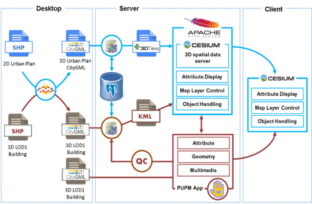
Figure 4. Configuration of 3D
Database and 3D Visualization of PUPM
5.3.2 Contributing and updating 3D building information
The PUPM application facilitates users to interact with 3D urban
plans of Jakarta and Bandung City. A custom-made python script is used
to enable automatic loading of CityGML files containing 3D building into
3DCityDB. This study also enables automatic quality control
provided by 3DCityDB to validate attributes and geometries
before updating the database. The PUPM prototype is also converting the
newly submitted to KML format. 3D tileset (KML) contains building
information and urban plan contributed by all stakeholders. The PUPM
preserves information from users and is validated by the authority as a
versioned object for temporal information. The temporal data will allow
3D land-use change analysis, which is planned to be developed in the
next version of PUPM. For the initial implementation, this study
provides 3D building in LOD-1 and LOD-2 for one district in Jakarta and
two districts in Bandung City in gml:Multisolid format. This
format allows users to query a building in city-wide data. Users are
also provided five sets of buildings in CityGML format to contribute 3D
spatial information into the PUPM system.
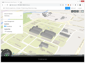
Figure 5. Overview of Digital
twin (3D city model) for the end-user interface (Location is Institute
Technology of Bandung Campus at Bandung City, Indonesia)
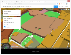
Figure 6. Overview of Digital triplets (3D city
model) for the end-user interface (Location is Institute Technology of
Bandung Campus at Bandung City, Indonesia).
5.3.3 Validating contributed 3D building data
In an exemplary implementation, PUPM shall use ISO 19157:2013 on Data
Quality to examine both geometries and attribute data submitted into the
system. However, the PUPM version 1.0 only examines the Logical
Consistency of data submitted by contributors. This functionality is
part of the 3DCityDB importing and exporting tool operating in
batch mode triggered by the validator role. This tool is configured to
detect and validate XML data containing 3D buildings in LOD 1, LOD2, and
LOD3. Validators may use their desktop-based software for assessing
other data quality elements prescribed in ISO 19157:2013 (i.e.,
Completeness, Positional Accuracy, Temporal Quality, and Usability
Elements). There is free and open-source software available for
examining data quality elements available for validators and users to
convert or asses data in CityGML format
(http://www.citygmlwiki.org/index.php/Freeware).
6. USABILITY ANALYSIS
The purpose of usability analysis is to help developers to improve
the PUPM application. ISO 9241-11:2018 defines usability as “the
extent to which a product can be used by specified users to achieve
specified goals with effectiveness, efficiency, and satisfaction in a
specified context of use.” Usability testing is intended to gauge
how the PUPM application will be used by a broad range of users with
different knowledge and skills in utilizing Geo-ICT. The usability test
attempts to resemble reality but not the actual situation and will not
declare the PUPM application reliable. ISO 9241-11 prescribes usability
testing to measure three attributes: effectiveness, efficiency, and user
satisfaction. However, this study only applies informal usability
testing, as highlighted by Nielsen (1994), to gauge effectiveness,
efficiency, and user satisfaction.
6.1 Preparation
The usability test was performed in October 2020 in an online form
with explanation and assistance through a virtual meeting. The
questionnaire was designed specifically for individuals that have Local
Spatial Knowledge (LSK) of a selected site. This study selected the
Institute Technology campus for usability testing, and the participating
students were considered ‘local citizens.’ The questionnaire
asked respondents to simulate how local citizens contribute LSK to the
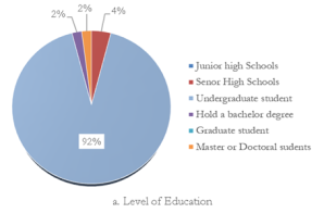
PUPM application. Forty-nine respondents participated in a usability
test; see Figure 7. The respondents performed all tasks of four roles
prescribed in the questionnaire. This study assigns respondents to the
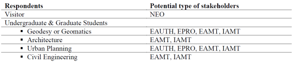
type of stakeholders; see Table 4.
Table 4: Respondents and type of stakeholders
6.2 Assessing effectiveness and efficiency
This study implements a post-release assessment using on-site testing
to evaluate the effectiveness of the PUPM application in the user’s
environment for improvement. In this approach, developers invite users
to perform several tasks, evaluate and validate the usability (Barnum
2011, pp 81-82). The usability test started with a brief description of
the PUPM application. The respondents had to explore all functionality
by themselves and relate to the sections in the questionnaire. This
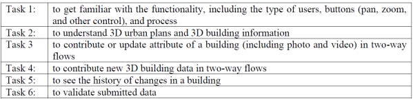
study gave respondents six tasks via an online meeting application to
assess the effectiveness and efficiency of the PUPM application . The
first task is to make the user familiar with functionalities. Task 2
aims to provide experience with multidimensional representation. The
third task requested respondents to use provided tools to update
buildings' characteristics, including the type of land-use, building
height, and recent pictures. These tasks were explicitly designed for
respondents familiar with the test site (ITB campus) and to let them
experience four roles in the PUPM application via online form. The
questionnaire contains a straightforward explanation for each task and
can be used as a guideline for completing tasks. In the usability test,
49 respondents representing three groups are expected to assess the
effectiveness of the PUPM application. The questionnaire was performed
during lockdown time, so most respondents used home internet facilities
or mobile tethering devices. Almost all respondents are young people
under 30 (48 out of 49), and 63.3% female. Seeing 3D urban plans will be
the first time for all respondents, and more than 75% of respondents
were self-declared to have sufficient knowledge and GIS skills (score
seven and above). However, almost half of the respondents assessed
themselves as having less knowledge and skill in 3D spatial data and 3D
visualization.
  |
|
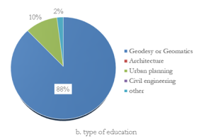
Figure 7. Characteristics of Respondents
There is only 57.8% of respondents were aware of the importance of
the 3D urban plan. All respondents are familiar with the location (ITB
campus), with 92% working or studying at the location (42 respondents
from the geodesy and geomatics department). From the questionnaire, the
PUPM application was proven to enable users to perform given tasks (see
Table 5) for accessing and contributing 3D spatial information for
monitoring the implementation of urban plans. Most of the respondents
(75.5%) succeeded in using navigation tools to locate a point and prove
relative position through the screen with the standard tool provided by
Cesium viewer. However, some respondents (33%) cast low scores (six or
below) on smoothness or unresponsive screens on their laptops at home.
Table 5: Six tasks for assessing the PUPM
application
6.3 User’s satisfaction
The respondents reported some delays due to slow internet connection
performance with big-sized data transfer, particularly on loading 3D
urban plans for the whole city. The PUPM requires a high-speed Internet
connection, which the home internet infrastructure in Indonesian city
still lacking. Indonesian internet speed. However, they cast high grades
(85%) on tools for navigating on-screen. More than half (56%) of
respondents still had difficulty identifying height violations of the
urban plan visually. The respondents score only average grade for
updating attributes (average grade 5 of 10) and contributing 3D building
data (average grade 5), which did not satisfy many portions of
respondents’ demand. The PUPM application was valued slightly better
(average grade) to provide urban plans access in 3D representation and
buildings' historical data. The problem encountered by the PUPM
application was mostly about slow responses accessed from respondents’
home internet devices. It would be expected to improve 3D data delivery
through slower internet access to gain more users’ satisfaction.
6.4 Summary
From the usability test, this study found three interesting facts to
be considered in developing an application for PUPM: (i) stakeholders
were adaptive to two-way information flows for co-producing urban
information; (ii) the use of multidimensional representation for the
physical and legal object were beneficial for PUPM; (iii) exchanging
multidimensional spatial representation using internet technology is
relying on communication infrastructure.
7. CONCLUSIONS AND FUTURE RESEARCH
7.1 Conclusion
This article aims to study the implementation of a two-way
information flow using multidimensional representation for PUPM. This
study is the first attempt to conceptualize the digital triplets concept
from 3D RRRs and develop a 3D user interface that enables two-way
information flows and 3D web visualization for supporting participatory
urban plan monitoring. The exploitation of 3D representation for land
management is considered beneficial to improve spatial thinking and
monitor and evaluate the implementation of the urban plan. Compared to
the 2D visualization, Representing Rights, Restrictions, and
Responsibilities (RRRs) using digital format over the two biggest
Indonesian cities' internet seem to leverage the discussion toward
monitoring and evaluation targets easier. The PUPM application can
minimize unnecessary debates (or even conflict) caused by interpretation
of physical characteristics of a violation of urban plan and creating
more time to explore solution creation. The spatially enabled government
and society were determined in continuous improvements for Indonesia’s
smart city project. Indonesian government declared a clear and
well-defined action plan for developing a 3D urban plan to accompany the
3D cadastre as mandated in the recently enacted Job Creation Act (2020).
Jakarta and Bandung City's government needs to develop digital triplets
for representing the legal object to accompany digital twin (for
physical objects) in their smart city system. The study found four
aspects to be highlighted for PUPM: (i) standardization will ensure
information interoperability in land tenure, land valuation, land-use
planning, and land development planning; (ii) the web application may be
suitable for maximizing outreach. The performance of the PUPM
application is highly dependent on the quality of ICT; (iii) 3D spatial
representation enables users to identify dimensional compliance of
building with urban plans; and (iv) a two-way direction was successfully
facilitated by the PUPM application to monitor the implementation of the
urban plan. However, this application has gaps to address, mainly
optimizing 3D data delivery to the potential contributors with minimal
internet access.
7.2 Future Research
As mandated by the spatial planning regulations, local governments in
Indonesia must develop a GIS for Spatial Planning (GISTARU) to support
the spatial planning process. Making 3D urban plans accessible may add
more attention to participants to contribute to the GISTARU to present
the actual condition with more realistic visualizations. This study may
stimulate more research for:
a) Improvement of Geo-ICT facility for supporting 3D data delivery.
Disseminating and contributing 2D spatial information requires a
sophisticated ICT infrastructure and systems, let alone 3D data. In the
digital transformation era, where most of the data transfer is through
the Internet, a smart city should consider 3D data delivery of its ICT
infrastructure. There is an urgent need to study the integration of Open
SII with the smart city ecosystem capable of delivering digital twin (to
represent physical objects) and digital triplets (representing legal
objects) to society helps add spatial enablement of a city.
b) Upgrading 3D building information contribution and updating module.
BIM stands for Building Information Modelling and is a 3D model-based
process used across the building design and construction process to
efficiently design buildings and plan every stage of building. The use
of BIM technology in construction project management is increasing in
the last decades. 3D models from BIM can be utilized for data input of
the PUPM application.
c) Standardization of four functions of land management.
Interoperability is vital for information integration, including for
participatory monitoring of the implementation of the urban plan. In
Indonesia’s two biggest cities (Jakarta and Bandung), 3D representation
of RRRs is also essential for land development planning, particularly
for urban planning and monitoring and granting businesses and investment
permits. Therefore, further research is expected to find a better
solution to improve digital triplets that contain a complete view of the
legal situation for land parcels and urban space.
d) Development of 3D visualization capability for a smart city. A smart
city must consider the representation of its legal objects, not only for
improving the city’s income (i.e., taxation) and social protection
(i.e., disaster management) and monitoring and evaluating its urban plan
performance and enforcement. Therefore, more research on 3D RRRs for
smart cities that cover objects below, on, and above the surface is
required. This study opens opportunities for a comprehensive framework
for developing, maintaining, and sharing digital twin and digital
triplets for smart cities.
REFERENCES
- Arnstein, S. (1969). A Ladder of Citizen Participation. Journal
of the American Institute of Planners. In The City Reader, 284-296.
Routledge.
- Arsanjani, J. J., Mooney, P., Zipf, A., & Schauss, A. (2015).
Quality assessment of the contributed land-use information from
OpenStreetMap versus authoritative datasets. In Arsanjani et al.
(Eds) , OpenStreetMap in GIScience. Lecture Notes in Geoinformation
and Cartography. 37-58. Springer: Berlin/Heidelberg, Germany. doi:
10.1007/978-3-319-14280-7_3
- Badan Perencanaan Pembangunan Nasional (Bappenas). (2016).
Posisi Vital Informasi Geospasial Bagi Perencanaan Pembangunan
Indonesia. Press Release. Retrieved from:
https://www.bappenas.go.id/id/berita-dan-siaran-pers/posisi-vital-informasi-geospasial-bagi-perencanaan-pembangunan-indonesia/
(Accessed on 2 May 2019).
- Bappenas. (2018). Rancangan Kebijakan Perkotaan Nasional.
Presentation. Diskusi Panduan Praktis Implementasi Agenda Baru.
Retrieved from:
http://jakberketahanan.org/2018/10/23/rancangan-kebijakan-perkotaan-nasional/.
(Accessed on 1 February 2019).
- Barnum, C. M. (2011). Usability testing essentials. Morgan
Kaufmann. ISBN:978-0-12-375092-1
- Batty, M. (2012). Building a science of cities. Cities, 29,
S9-S16.
- Batty, M. (2018). Digital twins. Editorial. Environment and
Planning B: Urban Analytics and City Science. 454(5), 817-820.
- Batty, M. (2018). Digital twins. Editorial. Environment and
Planning B: Urban Analytics and City Science. 454(5), 817-820.
- Batty, M., Hudson-Smith, A., Milton, R., & Crooks, A. (2010).
Map mashups, Web 2.0 and the GIS revolution. Annals of GIS, 16, 1,
1-13.
- Biljecki, F. (2017). Level of detail in 3D city models. Ph.D.
thesis, TU Delft, 353 pp.
doi:10.4233/uuid:f12931b7-5113-47ef-bfd4-688aae3be248.
- Biljecki, F., Stoter, J., Ledoux, H., Zlatanova, S., & Çöltekin,
A. (2015). Applications of 3D city models: State of the art review.
ISPRS International Journal of Geo-Information, 4(4), 2842-2889.
- Cemellini, B., van Oosterom, P., Thompson, R., & de Vries, M.
(2020). Design, development and usability testing of an LADM
compliant 3D Cadastral prototype system. Land Use Policy, 104418.
- Crooks, A., Pfoser, D., Jenkins, A., Croitoru, A., Stefanidis,
A., Smith, D., Karagiorgou, S,, Efentakis, A. & Lamprianidis, G.
(2015). Crowdsourcing urban form and function. International Journal
of Geographical Information Science, 29(5), 720-741.
- Daniel, S., & Doran, M. A. (2013). geoSmartCity: geomatics
contribution to the smart city. In Proceedings of the 14th Annual
International Conference on Digital Government Research, 65-71.
- Elwood, S. (2008). Grassroots groups as stakeholders in spatial
data infrastructures: Challenges and opportunities for local data
development and sharing. International Journal of Geographic
Information Science, 22, 71–90.
- Enemark, S. (2006). Understanding the Land Management Paradigm.
In P. van der Molen, & C. Lemmen (Eds.), Proceedings: Innovative
technology for land administration, 17-27. FIG - International
Federation of Surveyors.
- Enemark, S., & Sevatdal, H. (1999). Cadastres, Land Information
Systems and Planning-is decentralisation a significant key to
sustainable development. In UN-FIG Conference on Land Tenure and
Cadastral Infrastructures for Sustainable Development, 25-27.
- Frank, A. U., Fuhrmann, T., & Navratil, G. (2012). Extending 3D
city models with legal information. Usage, Usability, and Utility of
3D City Models–European COST Action TU0801, 02003.
Goodchild, M.F. (2007). Citizens as sensors: the world of
volunteered geography. GeoJournal, 69(4), 211-221.
- Goodchild, M.F. (2009). NeoGeography and the nature of
geographic expertise. Journal of Location-Based Service. 3, 82–96.
- Government Regulation 15/2010 on Spatial Planning
Implementation. Avalable at:
https://jdih.esdm.go.id/peraturan/PP%20No.%2015%20Thn%202010.pdf (in
Bahasa) (Accessed on 14 January 2018).
- Government Regulation 68/2010 on Procedures for the Role of the
Community in Spatial Planning. Avalable at:
https://peraturan.bpk.go.id/Home/Details/5092/pp-no-68-tahun-2010
(in Bahasa) (Accessed on 19 December 2017)
- Government Regulation 68/2010 on Procedures for the Role of the
Community in Spatial Planning. Avalable at:
https://peraturan.bpk.go.id/Home/Details/5092/pp-no-68-tahun-2010
(in Bahasa) (Accessed on 19 December 2017).
- Grieves, M. (2014). Digital twin: manufacturing excellence
through virtual factory replication. White paper, 1, 1-7.
- Gröger, G. & Plümer, L. (2012). CityGML–Interoperable semantic
3D city models. ISPRS Journal of Photogrammetry and Remote Sensing,
71, 12-33.
- Gröger, G., Kolbe, T. H., Nagel, C., & Häfele, K. H. (2012). OGC
city geography markup language (CityGML) encoding standard. Version
2.0. OGC 12-019. Open Geospatial Consortium.
- Gudowsky, N., & Bechtold, U. (2013). The role of information in
public participation. Journal of Public Deliberation, 9(1), 3.
- Herfort, B., Li, H., Fendrich, S., Lautenbach, S., & Zipf, A.
(2019). Mapping human settlements with higher accuracy and less
volunteer efforts by combining crowdsourcing and deep learning.
Remote Sensing, 11(15), 1799.
- Indrajit, A., Eresta Jaya, V., van Loenen, B., Snaidman, A.,
Ploeger, H. D., & Van Oosterom, P. J. M. (2019). Implementation of
Spatial Planning Package for Construction of an LADM Country
Profile: Reducing Asymmetric Access to Information of RRRs in
Indonesia. In Proceedings of the 8th Land Administration Domain
Model Workshop (LADM 2019). Kuala Lumpur, Malaysia, 1-3 October,
2019.
- Indrajit, A., Jaya, V. E., Van Loenen, B., Lemmen, C., Van
Oosterom, P., Ploeger, H., & Theodore, R. (2020). The Role Of The
Revised Land Administration Domain Model and Spatial Data
Infrastructure for Improving Ease Of Doing Business In Indonesia. In
Proceeding of the 2020 World Bank Conference On Land And Poverty.
Washington DC, March 16-20, 2020.
- International Organization for Standardization (ISO) (2012) ISO
19152:2012. Geographic information — Land Administration Domain
Model (LADM). ISO, Geneva, Switzerland.
- International Organization for Standardization (ISO) (2012) ISO
19152:2012. Geographic information — Land Administration Domain
Model (LADM). ISO, Geneva, Switzerland.
- International Organization for Standardization (ISO) (2013) ISO
19157:2013. Geographic information —Data Quality. ISO, Geneva,
Switzerland.
- ISO (2018) ISO 9241-11:2018. Ergonomics of human-system
interaction — Part 11: Usability: Definitions and concepts. ISO,
Geneva, Switzerland.
- Job Creation Act (2020) Law No. 11. Available at:
http://www.ilo.org/dyn/natlex/docs/ELECTRONIC/110587/137597/F1667266806/IDN110587.pdf
(Accessed on 14 December 2016).
- Kaufmann, J., & Steudler, D. (1998). Cadastre 2014: A vision for
a future cadastral system. In FIG Commission 7. The International
Federation of Surveyors (FIG).
- Kolbe, T. H. (2009). Representing and exchanging 3D city models
with CityGML. In 3D geo-information sciences,15-31. Springer,
Berlin, Heidelberg.
- Kolbe, T.H., Son, H.S., Chaturvedi, K., Willenborg, B.,
Donaubauer, A., Nagel, C., Yao, Z., Schulz, H., Willkomm, P., Hudra,
G., amd Kunde, F. (2019) 3D Geodatabase for CityGML Documentation
Version 4.2.
- Kuhn, W. (2005). Geospatial semantics: why, of what, and how? In
Journal on data semantics III, 1-24. Springer: Berlin, Heidelberg.
- LeGates, R., Tate, N. J., & Kingston, R. (2009). Spatial
thinking and scientific urban planning. Environment and Planning B:
Planning and Design, 36(5), 763-768.
- Lemmen, C. H. J., Van Oosterom, P. J., Kara, A., Kalogianni, E.,
Shnaidman, A., Indrajit, A., &Alattas, A. (2019). The scope of LADM
revision is shaping-up. In 8th Land Administration Domain Model
Workshop 2019.
- Lemmen, C. H. J., Van Oosterom, P. J., Kara, A., Kalogianni, E.,
Shnaidman, A., Indrajit, A., &Alattas, A. (2019). The scope of LADM
revision is shaping-up. In 8th Land Administration Domain Model
Workshop 2019.
- Lemmen, C., Van Oosterom, P., & Bennett, R. (2015). The land
administration domain model. Land use policy, 49, 535-545.
- McCall, M. K., & Dunn, C. E. (2011). Geo-information tools for
participatory spatial planning: Fulfilling the criteria for
‘good’governance? Geoforum, 43(1), 81-94.
- McLoughlin, J.B. (1969). Urban & Regional Planning: A Systems
Approach, 84–90. Faber and Faber: London, UK.
- Minang, P. A., & McCall, M. K. (2006). Participatory GIS and
local knowledge enhancement for community carbon forestry planning:
an example from Cameroon. Participatory learning and action, 54(1),
85-91.
- Ministry of Cadastre and Spatial Planning Regulation No. 1/2018.
Guideline on Developing Spatial Plan for City and Municipality.
Available at:
https://peraturan.bpk.go.id/Home/Details/103682/permen-agrariakepala-bpn-no-1-tahun-2018
(Accessed on 3 April 2019).
- Ministry of Cadastre and Spatial Planning Regulation No.
14/2020. Guidelines For Spatial Planning Audit. Avalaible at:
https://jdih.atrbpn.go.id/api/download/188/Permen%20ATR%20KBPN%20No.%2014%20Tahun%202020%20Full.pdf
(Accessed on 13 December 2020).
- Ministry of Cadastre and Spatial Planning Regulation No.
15/2017. Guidelines For Spatial Planning Audit. Avalaible at:
https://peraturan.bpk.go.id/Home/Details/103802/permen-agrariakepala-bpn-no-17-tahun-2017
(Accessed on 3 April 2019).
- Murata, M. (2004). 3D-GIS application for urban planning based
on 3D city model. In 24th annual ESRI International User Conference,
9-13.
- Murata, M. (2004). 3D-GIS application for urban planning based
on 3D city model. In 24th annual ESRI International User Conference,
9-13.
- National Research Council (NRC). (1997). Rediscovering
Geography: New Relevance for Science and Society. The National
Academies Press: Washington, DC. doi: 10.17226/4913.
- Nielsen, J. (1993). Usability engineering. Morgan Kaufmann.
ISBN: 978-0-12-518406-9. DOI: 10.1016/C2009-0-21512-1
- NRC. (2006). Learning to think spatially: GIS as a support
system in the K-12 curriculum. The National Academies Press:
Washington, DC. doi: 10.17226/11019.
- Open Geospatial Consortium (OGC). (2006). Candidate OpenGIS®
CityGML Implementation Specification (City Geography Markup
Language). OGC 06-057r1. Accessed in October 2019 from:
https://portal.opengeospatial.org/files/?artifact_id=16675 (Assessed
on 30 May 2019).
- Paasch, J.M., Van Oosterom, P., Lemmen, C. & Paulsson, J.
(2015). Further modelling of LADM's rights, restrictions and
responsibilities (RRRs). Land use policy, 49, 680-689.
- Prandi, F., Devigili, F., Soave, M., Di Staso, U., & De Amicis,
R. (2015). 3D web visualization of huge CityGML models.
International Archives of the Photogrammetry, Remote Sensing &
Spatial Information Sciences, 40.
- Ranzinger, M., & Gleixner, G. (1997). GIS datasets for 3D urban
planning. Computers, environment and urban systems, 21(2), 159-173.
- Roche, S. (2014). Geographic Information Science I Why does a
smart city need to be spatially enabled? Progress in Human
Geography, 38(5), 703-711. doi:10.1177/0309132513517365
- Roche, S. (2014). Geographic Information Science I Why does a
smart city need to be spatially enabled? Progress in Human
Geography, 38(5), 703-711. doi:10.1177/0309132513517365
- Roche, S. (2017). Geographic information science III: Spatial
thinking, interfaces and algorithmic urban places–Toward smart
cities. Progress in Human Geography, 41(5), 657-666.
- Seeger, C. J. (2008). The role of facilitated volunteered
geographic information in the landscape planning and site design
process. GeoJournal, 72(3-4), 199-213.
- Spatial Planning Act (2007) Law No. 26. Available at:
http://extwprlegs1.fao.org/docs/pdf/ins163446.pdf (Accessed on 14
December 2016)
- Steudler, D. (Ed) (2014). Cadastre 2014 and Beyond. Publication
No. 61. FIG. ISBN 978-87-92853-13-4
- Umeda, Y., Ota, J., Kojima, F., Saito, M., Matsuzawa, H.,
Sukekawa, T., Takeuchi, A., Makida, K. & Shirafuji, S. (2019).
Development of an education program for digital manufacturing system
engineers based on ‘Digital Triplet’concept. Procedia manufacturing,
31, 363-369.
- UN-Habitat (2015). International guidelines on urban and
territorial planning. HS/059/15E. United Nations Human Settlements
Programme, Nairobi.
- Van Oosterom, P., & Lemmen, C. (2015). The land administration
domain model (LADM): Motivation, standardisation, application and
further development. Land use policy, 49, 527-534.
- Wilcox, D. (1994). The Guide to Effective Participation. Joseph
Rowntree Foundation. Delta Press, Brighton. ISBN 1-870298-00-4.
- Yao, Z., Nagel, C., Kunde, F., Hudra, G., Willkomm, P.,
Donaubauer, A., Adolphi, T., & Kolbe, T. H. (2018). 3DCityDB-a 3D
geodatabase solution for the management, analysis, and visualization
of semantic 3D city models based on CityGML. Open Geospatial Data,
Software and Standards, 3(1), 1-26.
BIOGRAPHICAL NOTES
Agung Indrajit obtained an MSc in Aerospace and
Geodetic Engineering in 2008 from Technical University of Munich,
Germany. From 2002 until now he worked at Geospatial Information Agency
(BIG), Republic of Indonesia. From 2005 to 2009 he was a member of the
German Indonesian Tsunami Early Warning System. From 2012 to 2016 he was
Head of Geospatial Information Management, where he was involved in
developing Indonesian National Spatial Data Infrastructure. Since 2016,
he conducting PhD research on “4D Open Spatial Information
Infrastructure-Participatory Urban Plan Monitoring In Indonesian
Cities”. He is a member of TU Delft and FIG for the revision of the Land
Administration Domain Model, ISO 19152.
Peter van Oosterom obtained an MSc in Technical
Computer Science in 1985 from Delft University of Technology, the
Netherlands. In 1990 he received a PhD from Leiden University. From 1985
until 1995 he worked at TNO, The Hague as computer scientist. From 1995
until 2000 he was senior information manager at the Dutch Cadastre,
where he was involved in the renewal of the Cadastral (Geographic)
database. Since 2000, he is professor at the Delft University of
Technology, and holds the chair ‘GIS Technology’, He is the current
chair of the FIG Working Group on ‘3D Cadastres’. He is co-editor of the
International Standard for the Land Administration Domain Model, ISO
19152.
Bastiaan van Loenen studied geodesy at TU Delft, the
Netherlands and Spatial Information Engineering and Science at the
University of Maine, USA. He has a PhD from Delft University of
Technology. As an associate professor at the Delft University of
Technology, he holds the chair of Knowledge Centre Open Data TU Delft’s
Faculty of Architecture and The Built Environment. From 2011 until 2015
he was chair of the legal and socio-economic committee of the Global
Spatial Data Infrastructure Association (GSDI). Currently he is the
chair of Geo-information infrastructure committee of the Dutch Geodetic
Commission.
M. Hasannudin Yusa obtained an MSc in Geodesy and
Geoinformation Science in 2018 from Technical University of Berlin,
Germany. From 2009 until now he worked at Geospatial Information Agency
(BIG), Republic of Indonesia. From 2009 to 2016 he was programmer at
Center for Spatial Data Management and Dissemination at BIG. Since 2018
he was senior developer of the Indonesian National Spatial Data
Infrastructure.
Deni Suwardhi obtained an MSc in Informatics in 1999
from Institute Technology of Bandung (ITB), Republic of Indonesia. In
2006, he received a PhD from University Technology of Malaysia. From
1996 he worked as lecturer in Department of Geodesy and Geomatics, ITB.
CONTACTS
Agung Indrajit
Delft University of Technology
Faculty of Architecture and the Built Environment
P.O. Box 5030, 2600 GA Delft, THE NETHERLANDS
Tel.: +31 0624866450
Website:
https://www.tudelft.nl/staff/a.indrajit/
Peter van Oosterom
Delft University of Technology
Faculty of Architecture and the Built Environment
P.O. Box 5030, 2600 GA Delft, THE NETHERLANDS
Tel.: +31 15 2786950
Website:
https://www.gdmc.nl
Bastiaan van Loenen
Delft University of Technology
Faculty of Architecture and the Built Environment
P.O. Box 5030, 2600 GA Delft, THE NETHERLANDS
Tel.: +31 15 2786950
Website:
https://kcopendata.eu/
M. Hasannudin
Badan Informasi Geospasial
Pusat Pengelolaan dan Penyebarluasan Informasi Geospasial
Jl. Raya Jakarta - Bogor KM. 46 Cibinong 16911, INDONESIA
Tel.: +62 021- 8753407
Website:
https://tanahair.indonesia.go.id/
Deni Suwardhi
Institute Technology of Bandung
Faculty of Earth Sciences and Technology
Jalan Ganesa No. 10 Bandung 40132, Indonesia
Tel.: +62 022 – 2514990
Website:
https://gd.fitb.itb.ac.id/people/academic-staff/deni-suwardhi/


