Article of the Month -
November 2010
|
Social Tenure Domain Model: What It Can
Mean for the Land Industry and for the Poor
Clarissa AUGUSTINUS, UN-HABITAT
 This article in .pdf-format
(16 pages, 111 KB)
This article in .pdf-format
(16 pages, 111 KB)
1) This paper is an invited paper presented at
the FIG Congress 2010 in Sydney, Australia, 11-16 April 2010, This paper
is written by Dr. Clarissa Augustinus from UN-HABITAT, with whom FIG has
had an outstanding cooperation for many years. Therefore - in addition
of being an excellent presentation on social tenure domain model - this
paper also recognises the long-term cooperation between UN-HABITAT and
FIG. Clarissa Augustinus is a social scientist who has had large impact
in the land surveying world.
Handouts
of this presentation as a .pdf-file.
Key words: Social tenure, domain model, technical gaps, Global
Land Tool Network, Tools, increased market share, pro poor
SUMMARY
Most developing countries have less than 30 percent cadastral
coverage. This means that over 70 percent of the land in many countries
is generally outside the land register. This has caused enormous
problems for example in cities, where over one billion people live in
slums without proper water, sanitation, community facilities, security
of tenure or quality of life. This has also caused problems for
countries in regard to food security and rural land management issues.
The Global Land Tool Network (GLTN), a coalition of international
partners, including FIG, has taken up this challenge and is supporting
the development of pro poor land management tools, to address the
technical gaps associated with unregistered land, the upgrading of slums
and rural land management, among other things. The security of tenure of
people in these areas relies on other forms of tenure, not individual
freehold. Most rights and claims off register are based on social
tenures. GLTN partners support a continuum of land rights, which
includes rights that are documented, undocumented, individual and group,
pastoralist, slums, legal, illegal and informal. This range of rights
generally cannot be described relative to a parcel, and therefore new
forms of spatial units and a domain model has been developed to
accommodate these social tenures, termed the Social Tenure Domain Model
(STDM) (Augustinus, Lemmen and van Oosterom: 2006). This is a pro poor
land information management system which can be used to support the land
systems of the poor in urban and rural areas, but which can also be
linked to the cadastral system so that all information can be held on
one system.
This approach will open up new markets to the land industry and it
will also be an opportunity to develop new skills and improve management
skills. STDM could make it possible for all citizens to be covered by
some form of land administration system, including the poor, thereby
improving the land management capacity of the industry, as well as
addressing upcoming challenges such as climate change. Also, STDM should
contribute to poverty reduction, as the land rights and claims of the
poor are brought into the formal system over time. It will improve their
security of tenure, increase conflict resolution, limit forced
evictions, and help the poor to engage with the land industry in
undertaking land management such as city wide slum upgrading or rural
land management. The pro poor land management approaches under
development by GLTN partners is a new way of doing business and is key
to solutions for the challenges of today and tomorrow. GLTN is focusing
on filling the gap by building the technical and governance solutions
and the capacity for the industry to use them. The technical gap covered
by STDM is in the critical path of the delivery of a number of the
Millennium Development Goals namely, Goal 1 on food security, Goal 3 on
the promotion of gender equality and the empowerment of women, and Goal
7 on ensuring environmental sustainability, including improving the
lives of slum dwellers.
1. INTRODUCTION
There are now more people living in urban areas than in rural areas
and of the total urban population of 2.3 billion in 2005 at least 810 or
39 percent live in slums (Moreno: N.D). Most people living in slums do
not have registered land rights. This means that there is no cadastre in
these areas or it does not match the de facto land tenure situation.
Cadastres do not just deliver security of tenure. As Williamson,
Enemark, Wallace and Rajabifard (2009) argue, cadastres also deliver a
land administration system. It is this system that makes the cadastre
invaluable for other purposes, such as planning, service delivery,
environmental management, city management, cost recovery, land tax, and
land management, such as slum upgrading.
In developing countries cadastral coverage is often less than 30
percent of the country (Lemmen, Augustinus, Haile and van Oosterom:
2009). This means that about seventy percent of the land in many
countries is outside of the freehold parcel based land administration
system and its land information system. This implies that people living
in these areas are often at a disadvantage, not just in regard to
security of tenure, but also in regard to such things service delivery
and land management approaches. The people in the seventy percent
generally use a wide variety of social tenures to secure their land
rights and claims. These tenures include documented, undocumented,
individual and group, legal, illegal and informal and over-lapping
rights and claims, such as those of slum dwellers, pastoralists, women
whose rights are often nested in family rights, rights of groups, and
multiple over-lapping claims in post conflict areas. This range of
tenures cannot be easily captured on conventional cadastral and land
administration systems because they are not based on unique parcel based
polygons, which are also legal evidence of land rights.
The Global Land Tool Network, a coalition of international partners,
has been promoting the idea that firstly, the variety of rights and
claims in land should be seen as a continuum of land rights which can be
incrementally upgraded over time, beginning with weak rights based on
political support, right up to full freehold, with steps in between for
informal and formal rental agreements/leases, migration routes, claims
on post conflict property and so. There will be different continuums in
different countries and different contexts. Across a continuum different
tenure systems may operate, and sites in a settlement may change status
over time. (UN-HABITAT: 2008). Secondly, the continuum of land rights
requires a new type of land information management system and land
administration system. This is required to implement the continuum of
land rights and claims and systematise them also for the purpose of land
management. The Social Tenure Domain Model (STDM) (Augustinus, Lemmen,
van Oosterom: 2006) was designed to fill this technical gap.
This technical gap was identified as early as 1998 (UNECA: 1998).
First a number of land tenure policy specialists working in Africa, Asia
and South America identified the fact that there were a range of social
tenures that could not fit with conventional land registration systems,
in terms of the types of rights held, and/or the spatial description of
the rights, and/or the land title conditions. These policy specialists
came to prominence in the 1980s and 1990s with the result that there was
little support for the use of conventional titling for customary areas
for example (Dorner: 1992; Bruce and Migot-Adholla: 1993; Migot-Adholla,
Hazell, Blarel and Place: 1991). By the end of the 1990s and the
beginning of 2000, a number of people working in the land administration
field also became convinced that conventional land administration
systems were not always appropriate for the range of tenure types that
exist such as customary areas, pastoralists and for slums (UNECA: 1998;
Barry and Fourie: 2002; Fourie, van der Molen and Groot: 2002).
Taking this further, it became clear over time that the 70 percent of
the areas outside the land registry in many developing countries, which
areas had no land administration system and land information management
system, generally meant that land management could not be undertaken in
these areas. It also became clearer over time that this impacted a wider
range of issues aside from security of tenure for the lower income
groups. That is, this gap was contributing directly to chaotic and
unsustainable cities, problems around land degradation and water shed
management, deforestation, the inability to solve land in many post
conflict environments, chaotic traffic and a proliferation of slums.
Lemmen took the lead on trying to develop solutions to fill this
technical gap from 2002 onwards, by starting to develop the Social
Tenure Domain Model (STDM) at the conceptual level (Augustinus, Lemmen,
and van Oosterom: 2006). ITC was then financially supported by the
Global Land Tool Network (GLTN) to develop the technical aspects of
STDM. GLTN is facilitated by UN-HABITAT and funded by Norway and Sweden,
which are GLTN partners. The technical development of STDM has been
undertaken with the encouragement of the President of International
Federation of Surveyors, Stig Enemark, who also committed FIG to working
towards filling this technical gap by supporting research around STDM.
The Global Land Tool Network (GLTN) is a coalition of international
organisations who have agreed on an agenda of 18 pro poor land
management tools for urban and rural areas (www.gltn.net).
Most tools are national but have rural and urban applications. These
tools are being developed by the partners not just as tools on their
own, but also linked to cross cutting issues such as gender, the
involvement of the poor users, land governance, and the need for
capacity building. The continuum of land rights (which is about the
incremental acquisition of rights over time), and STDM are two of the
GLTN tools. The partners working on STDM include UN-HABITAT, FIG, and
the World Bank and ITC, which has been at the forefront of developing
STDM. Other GLTN partners from the land administration industry in GLTN
include FAO, the Commonwealth Association of Surveying and Land Economy,
Federation des Geometres Francophone and the Royal Institution of
Chartered Surveyors. There are also other types of partners, such as
from international civil society and research and training institutions.
I will argue that by filling this technical gap, through such tools
as STDM, land managers, land administrators and land surveyors will have
an increased market share. Also they will be able to position themselves
centre stage in solving the problems of today, whether it be in regard
to climate change, or the creation of sustainable cities and the
prevention of slum growth, or ensuring food security for nations. They
will be able to do this because they will have a greater range of
options, tools and solutions to offer policy makers and politicians on
how to address the issues of the 21st century. Also, STDM could enable
professionals to deliver services to all citizens, thus addressing the
critical issue of equality and justice and thus contributing to stable
cities, and respect for the law.
The paper will also describe how the poor can benefit from STDM,
through improved security of tenure, more services, increased conflict
management and more predictability in their lives, including being able
to leave their land to their children when they die, a critical issue
for poor people. All of these will contribute to poverty reduction and
decrease the impact of human settlement related shocks, such as forced
evictions, on the vulnerable, such as women and the poorest of the poor.
The conclusions of the paper is that the land industry has a
technical gap in their tools and using current approaches cannot deliver
robust security of tenure, land information management, land
administration systems or land management at scale, particularly in
regard to developing countries, both in the rural and urban areas. This
gap is affecting the sustainability of the planet and its cities,
forests and food production among other things. The industry has taken
up this challenge but still more needs to be done and done more quickly.
2. THE URBAN CHALLENGE FOR LAND ADMINISTRATORS
Half of humanity now lives in cities, and by 2050 70 per cent of the
world’s people will reside in urban areas. By the middle of the 21st
century the total urban population of the developing world will more
than double, increasing from 2.3 billion in 2005 to 5.3 billion in 2050.
“Urban growth rates are highest in the developing world ..(which is)
responsible for 95 per cent of the world’s urban population growth”
(UN-HABITAT: 2008). However, many cities will be characterized by urban
poverty and inequality, and urban growth will become virtually
synonymous with slum formation. Indeed, Asia is already home to more
than half of the world’s slum population (581 million), followed by
sub-Saharan Africa (199 million), where 90% of new urban settlements are
taking the form of slums. As shown in figure 1 (below), at least one
third of the urban population in the developing world lives in slum
conditions.
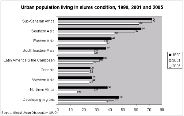
Figure 1: Estimated urban population living in slum condition
between 1990 and 2001 2. Moreno:
(N.D).

2.The drastic reduction of the percentage of urban
population living in slums, particularly in Sub-Saharan Africa between
2001 (72 per cent) and 2005 (62 per cent) is largely explained by the
change in slum definition which now includes the use of pit latrines. A
slum household is defined as a group of individuals living under the
same roof lacking one or more of the following conditions: access to
improved water; access to improved sanitation facilities; sufficient
living area (not more than three people sharing the same room);
structural quality and durability of dwellings; and security of tenure
(UN-HABITAT: 2008).
From another angle, the space taken up by urban localities is
increasing faster than the urban population itself. Between 2000 and
2030, the world’s urban population is expected to increase by 72 per
cent, while the built-up areas of cities of 100,000 people or more could
increase by 175 per cent. The land area occupied by cities is not in
itself large, considering that it contains half the world’s population.
Recent estimates, based on satellite imagery, indicate that all urban
sites (including green as well as built-up areas) cover only 2.8 per
cent of the earth’s land area. This means that about 3.3 billion people
occupy an area less than half the size of Australia (Angel et al, 2005
cited by UNFPA, 2007). Over the next 25 years, over 2 billion people
will be added to the growing demand for housing, water supply,
sanitation and other urban infrastructure and services. What is critical
when considering this number is the order of magnitude. Close to 3
billion people, or about 40% of the world’s population by 2030, will
need housing and basic infrastructure and services. But as I will argue,
the land industry does not have all the technical tools and solutions
needed to meet this challenge and new ways of doing business and a range
of new pro poor land management tools need to be developed to meet this
challenge. The Social Tenure Domain Model is an attempt to fill one of
these technical gaps.
Finally, the Millennium Development Goal 7, Target 11, commits the
international community to achieving a significant improvement in the
lives of at least 100 million slum dwellers by the year 2020. The
attainment of even this very limited goal is not promising. Reporting on
the attainment of Goal 7, the United Nations (2007) stated that “(i)n
2005, one out of three urban dwellers was living in slum conditions –
that is lacking at least one of the basic conditions of decent housing:
adequate sanitation, improved water supply, durable housing or adequate
living space.” UN-HABITAT states that few countries are on track for
reaching Goal 7, which would imply a rapid and sustained decline in
slums. Countries that are the furthest from the slum target goals are
mostly in Sub Saharan Africa (2006). The Social Tenure Domain Model
(STDM) is a key tool which could deliver this target and the reasons for
this are described below. It should also be noted that the technical gap
covered by STDM is in the critical path of the delivery of other
Millennium Development Goals namely, Goal 1 on food security and Goal 3
on the promotion of gender equality and the empowerment of women.
3. THE CONTINUUM OF LAND RIGHTS AND THE SOCIAL TENURE DOMAIN
MODEL
Moving away from individual freehold parcel based tenure systems and
adopting a range of rights and claims in order to extend security of
tenure to more people, including the poor, implies that a new form of
land administration has to be designed. Adopting a continuum of land
rights made the land administration technical gap obvious, which
technical gap is covered by STDM.
UN-HABITAT proposed the continuum of land rights approach in 2003 and
this was further developed and adopted by the Global Land Tool Network
partners. An example of the continuum is given below (Figure 2.)
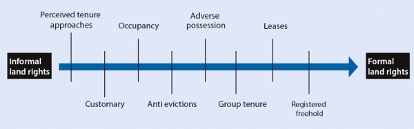
Figure 2: Continuum of land rights (UN-HABITAT: 2008)
The continuum of tenure types is a range of possible forms of tenure
which can be considered as a continuum. Each continuum provides
different sets of rights and degrees of security and responsibility.
Each enables different degrees of enforcement. Across a continuum,
different tenure systems may operate, and plots or dwellings within a
settlement may change in status, for instance if informal settlers are
granted titles or leases. Informal and customary tenure systems may
retain a sense of legitimacy after being replaced officially by
statutory systems, particularly where new systems and laws prove slow to
respond to increased or changing needs. Under these circumstances, and
where official mechanisms deny the poor legal access to land, people
tend to opt for informal and/or customary arrangements to access land in
areas that would otherwise be unaffordable or not available
(UN-HABITAT:2008).
Drawn from Fourie and Nino Fluck (2001) it is clear that the
different types of tenures found in the continuum pose a challenge to
conventional land administration systems as they are not generally
parcel based. Parcels have been the basic unit of data collection and
the linking mechanism to other information in a database. This has meant
that most information about the land in developing countries could not
be utilized in Land Information Management (LIM) systems, as the
information is generally not parcel/polygon based, let alone cadastral
parcel based.
A few examples from urban areas illustrate this:
- Privately owned land. The location of the informal settlement
does not always precisely match the cadastral parcels and is likely
to cover many properties in one spatially contiguous unit
(Cowie:1999; Jenkins et.al:1986);
- Customary land, including in urban areas, is conventionally not
parceled (Latu:N.D).
- Often the boundaries of the informal settlers’ properties do not
accord with the cadastral layout, and this can vary across the
settlement and between settlements (Jenkins et.al.:1986).
- State land. Often the state does not have an inventory of its
land. Also, often state land has not been parceled. Generally the
informal settlement boundaries do not coincide with the state land
boundaries (Jenkins et al.:1986);
Once it was recognized that freehold parcel based tenures could not
go to scale and that to supply security of tenure at scale we would have
to adopt the continuum of land rights, it became inevitable that we
would have to re-think our land administration systems, also in regard
to identifiers. This in turn would mean that we would need a new land
information management system that could handle such a range of
identifiers. Lemmen’s design of STDM has done this and gone even
further. “STDM.. is intended to provide a land information management
framework that would integrate formal, informal, and customary land
systems, as well as integrate administrative and spatial components.”
This is “..possible through tools that facilitate recording all forms of
land rights, all types of rights holders and all kinds of land and
property objects / spatial units regardless of the level of formality.”
(Lemmen, Augustinus, Haile, van Oosterom: 2009).
To conclude, once the off register social tenure arrangements of
people, particularly the poor was recognized, this meant that new
technical challenges emerged for the land industry. It is only be by
addressing these challenges that it will be possible to meet the needs
of the poor and deliver sustainable land management for the planet. In
meeting this challenge the industry will also be able to extend its
markets and position itself even better with policy makers.
4. WHAT WILL STDM DELIVER TO THE LAND INDUSTRY
By developing tools such as STDM to fill this technical gap, the land
industry will be able to go to scale and cover the whole of any country,
including the areas that are not currently covered by the cadastre,
thereby extending their markets and delivering services to all segments
of the population. This in turn will improve the professionalism with
which the land industry serves its clients. It will also make land
markets more efficient and improve our ability to address the land
management challenges of the 21st century.
4.1 Ability to go to scale
In developing countries often the coverage of the Surveyor General
and Registry land records is less than 30 percent of the country
(Lemmen, Augustinus, Haile and van Oosterom: 2009). This means that 70
percent and more of the country is outside of the freehold based land
administration system and its cadastral land information system. This in
turn means that land management in these areas is very difficult. Sub
Saharan Africa and slum areas are examples of this and are well known to
be data poor, which in turn creates problems for land managers
undertaking city wide management and slum upgrading for example. STDM
could fill that data gap and make it possible to go to scale also by
including the low income areas. This would mean that more practical
policy for the whole city could be developed and implemented. This would
be possibly for a range of reasons.
Firstly, currently countries and local governments are limited in
their ability to go to scale in terms of land records and land
management. The development of STDM data, based on the continuum of
rights tenures, would be critical for them to be able to cover their
jurisdictions systematically, so that all citizens would have some sort
of access to land and security of tenure. Local governments and their
land officials have a key role in driving land management, land use and
resource allocation and sustainable development. They have been hampered
in their job by not having sufficient data, as they are generally
reliant on the national, or federal, system to produce land parcels to
which they can link their attributes. STDM could make it possible for
these land officials to fill the data gap and assist their local
authorities to fulfil their functions better, as well as improve their
ability to deliver for all the citizens of the city, including the poor.
This could be done also because existing data sets could be over laid
with STDM data in a way that could increase the knowledge of policy
makers and planners. This would be particularly appropriate for
environmental management, both of natural resources and the built
environment, as well as the design of sustainable land use patterns.
Looking to the future, STDM could be critical for local authorities to
be able to manage the effects of climate change.
Secondly, through the introduction of STDM, low income communities
will incrementally become used to land information systems, and some of
the legal issues surrounding land. This capacity building is critical
for maintaining currency in any system, and will be of great use once
these people move into more legal systems, where land records often lose
currency because users do not see the value of updating them. Once STDM
information is available for any particular low income community it will
make it quicker and more efficient to plan the area, to upgrade it,
deliver trunk infrastructure and affordable services. It will be quicker
and more efficient because the data needed to do the initial planning
will already exist; and some capacity will already exist in the
community in regard to land and land information, making it easier to
negotiate with the community in regard to land readjustment, upgrading
and/or land acquisition and compensation. This will also make it safer
in some areas for surveyors to undertake surveys. This efficiency in
turn should make it possible for the land industry to scale up their
role in city management and improve their unit costs. Re-tooling costs
could be offset quicker through these efficiency gains.
Thirdly, STDM would make it possible to link information to other
mapping agencies and data providers which are not currently able, or
willing, to use cadastral data because of its high accuracy requirement
and/or more importantly, shortfalls in coverage. This again could
improve the scale of service delivery and land management.
Fourthly, by systematising information, including rights (formal,
informal and customary), claims, over-lapping rights and claims and
disputes, oral and written contracts, STDM could make an important
contribution to bringing peace in post conflict countries where land has
been a key driver of conflict. The role of STDM in post conflict areas
has already been identified as a need, and this is a critical new market
for the land industry. Generally land disputes are not addressed
systemically, or in time, in these situations because of this technical
gap, and STDM would also enable land dispute resolution to be scaled up,
thereby directly contributing to peace building.
Finally, STDM could generate data so a country could better measure
its coverage in regard to security of tenure. Currently indicators on
security of tenure are limited by a lack of reliable data. It would also
improve the ability of the land industry to make cross country
comparisons.
4.2 Improved professionalism
The failure of current conventional systems to deliver at the
necessary scale, because of the technical gap covered by STDM, has left
land professionals in a weaker position than they should be in regard to
policy makers. STDM, by addressing a technical gap and giving new
options, tools and solutions will make it possible for land
professionals to increase their ability to influence decision makers.
People who can assist policy makers to address the problems of chaotic
and unstable cities, impossible traffic problems, land conflict, and
climate change issues, are the leaders of the future.
Also, STDM could improve the symmetry in land information in general
which has the potential to decrease corrupt practices found in some of
the land agencies and among some land professionals. This could improve
the image of the land industry as a whole in those countries.
From another angle, STDM could increase the market of the land
industry by incorporating all sorts of transactions over the continuum
of land rights, not just freehold. It has been hard for the industry to
engage with the low income part of the market also because of the lack
of affordable pro poor land tools, particularly the documenting of
social tenures and information management systems. Market share could
also be increased through the development of a wider range of services.
STDM data could be used like cadastral data for business processes, such
as developers undertaking slum upgrading, commercial concerns delivering
to the informal economic sector of bread, alcohol, dry cleaning and so
on.
In regard to this, STDM data will include a range of types of data
including dirty data, legal and informal data. The land industry will
need to adjust to this range of data, and how to use it as over laid
data, in order to improve land use planning, land management and
environmental planning. Non specialised people will also produce some of
the data. New skills will be needed in interpretation of the data and
the management of the results. New skills will also be needed to manage
a different level of data gatherers. Some types of risk will decrease
and other risks will emerge, and these will have to be managed. A new
type of land information manager and land manager is likely to emerge to
use STDM, which will need capacity building and resources.
A specific example of these potential new roles and opportunities
relates to land and the courts. Many countries in the world have huge
case back logs of land cases, or cases which have underlying issues
related to land. STDM can identify and describe the range of land
disputes that exist, and at an earlier stage prior to entering court,
thereby decreasing the number of cases in court and increasing the
number of cases that could be solved through Alternative Dispute
Resolution mechanisms. This has always been a crucial role of surveyors
and may strengthen the role and scope of community leaders, para-legals,
government officials, surveyors and lawyers involved in mediation.
Finally, the ability of the land industry to deliver to all citizens,
including the poor, and not just the rich, middle class and commercial
classes as is the case currently in many countries, could in time
improve the equality and social justice that is often missing in the
land sector. Until the technical gap currently covered by STDM is
filled, this issue will continue to block the attainment of the goal of
land reform.
4.3 More efficient land markets
By using STDM the land markets should operate more efficiently as
well. This efficiency will come about for a number of reasons. Firstly
there will be more symmetry about land information to all stakeholders,
increasing transparency for buyers. Secondly, both the formal and
informal land markets will be able to be placed on the same land
information system, as the STDM can also be linked to the cadastral
information system, improving symmetry of information even more.
Thirdly, because of the availability of STDM data it will be easier for
negotiations to take place on land that has been frozen by family and
neighbourhood disputes and/or deceased estates. This will be of
particular importance in Muslim countries where shared inheritance is
practiced.
Fourthly, land acquisition for development will be easier because
data will be available from the outset, hopefully linked to pro poor
compensation packages. This is particularly important in peri-urban
areas where urban development is often concentrated, yet land records
reflecting the legal reality are often the weakest. Fifthly, because of
data availability, land use planning will be more efficient and
realistic and hopefully affordable. Sixthly, one of the major delays in
land documentation (registration) is adjudication. STDM data will make
systematic adjudication more efficient as it could build on existing
data and potential disputes can be identified before hand.
Seventhly, land disputes and the type of dispute will be known to all
buyers, who will be able to factor this into value and price. Eighthly,
through the STDM system which supports a range of rights and not just
freehold, buyers will be able to better assess the security of tenure of
different documents and the value of the land will more accurately
reflect the land market. Ninthly, land use conflicts will be able to be
identified at an earlier stage and dealt with, with the result that
there could be less land related court cases. Court cases can freeze
land for years, so STDM may well free up this land earlier. Also, since
STDM will provide more realistic information which will be reflected in
the land value, the market will indirectly influence quicker resolution
of land disputes.
Tenthly, by expanding the conventional systems and formal markets to
link to STDM, the other forms of tenure, and the informal markets, the
supply and demand currently focused on freehold, which causes economic
distortions and increases corruption, is likely to be re-set at a new
position. All this will improve the functionality of the land markets.
Finally, surveyors and information managers will have to manage the
transition of the land and data, including STDM data, through different
stages of the continuum of land rights in a way that “..anticipates the
complexities of a fully developed formal land market.” (Williamson,
Enemark, Wallace, Rajabifard: 2009).
5. WHAT WILL STDM DELIVER TO THE POOR
Currently, most poor people are not covered by a land administration
system and its linked land information management system. This means
that they do not benefit from these systems in regard to tenure
security, planning and service delivery, slum upgrading, resolution of
disputes and so on. STDM would make it possible for a country and/or
local government to go to scale and include low income people in their
information systems and in their land delivery approaches. This would
have a direct impact on the quality of life of the poor and on poverty
reduction. It would also have a direct impact on the stabilisation and
governance of cities, also through the empowerment of the poor. This is
because it is not possible to create sustainable cities if the poor are
not part of the solution.
5.1 Improved Security of Tenure at Scale
Many poor rely on informal and/ or customary land rights, which are
often not administered and documented systematically. STDM is designed
as a pro poor land information management system to underpin the types
of social tenures which the poor use to give them security of tenure.
STDM could make it possible to document systematically and upgrade these
tenures over time along a continuum of land rights. Documentation of
some kind available to the poor, which is affordable and relevant to
their situations and social tenures, will increase their security of
tenure in terms of use rights and land ‘rights’.
STDM will be used to document land rights, claims and over-lapping
rights prior to conventional adjudication, planning, surveying and
registration, which is expensive, takes a lot of time and normally is
out of the reach of the poor. Also the STDM information will include
both de facto as well as de jure land ‘rights’ and use rights on the
same system. The availability of data and on the same system will mean
two things. Firstly, this will enable more effective, efficient and
affordable city wide land use planning, which has often suffered from
data deficiencies. This will make it possible to service slum areas more
easily and link it to the trunk infrastructure, also because it will
give the poor an address, making it possible to undertake cost recovery
on services. This will increase service delivery to the poor, such as
water. Secondly, a major cost and time issue related to land
registration is the information produced during adjudication in formal
land titling processes. The STDM data will make adjudication, surveying
and documentation at some later point cheaper, more efficient and faster
thus making it possible for the poor to be brought into the formal
systems earlier, thereby increasing their security of tenure along the
continuum of land rights faster.
The STDM will hold information on the rights and claims of the poor
and the information from the cadastre, state asset register, and
municipal asset register (where this information is available).
Knowledge of the legal status of the land will limit evictions. A common
problem has been that state officials allocate land to investors and
developers which is already occupied by the poor, because there is no
information about land rights on their land information system. By
linking the cadastral information to STDM information it will be
possible to ascertain whether the land is already occupied and claimed
and is not empty. Mozambique has used this kind of approach effectively.
Also, the poor will be able to identify the legal owner of the land they
occupy with whom they can negotiate. Renters in the slum could be
protected during this process as their information will also be
identified on the STDM -their rights and claims as well as that of the
‘owners’ would be identified. NGOs in the Philippines have used this
kind of approach to effectively negotiate with land owners. An operating
STDM could also make it possible for the poor to argue for compensation
when land acquisition is undertaken, and help to standardise
compensation procedures, as they could be based on STDM information.
From another angle, slum upgrading currently tends to be project or
community focused because of a lack of city wide land information and
land management. An STDM type tool is in the critical path of city wide
slum upgrading and the provision of planning and service provision to
the poor at scale. City wide land management will be possible once the
entire city is covered with conventional cadastral information
management system linked to the STDM information, as the information
will be at scale. Not only will it be possible to work out more
affordable and efficient options, but it will also be possible to
implement the policies better. It will be possible to carry out improved
policy planning and implementation for the city in general, as well as
road, trunk infrastructure, services and community facilities, as well
as environmental management. This is turn will impact the lives of the
poor through for example, improved transportation (the poor often spend
hours commuting); cheaper water supply (the poor pay more than the rich
generally for water); more accessible health facilities (the poor often
have to travel hours to get medical attention and are more reliant on
hospitals as the rich tend to use private doctors).
Finally, a key issue for the poor is whether their children can
inherit the land they are holding. STDM could make it easier for the
poor, particularly women, to inherit the land as it could provide the
necessary information for the resolution of disputes, as well as supply
some evidence of rights and claims which could under the right
conditions enable forums, such as courts, to make better and less
arbitrary decisions.
5.2 Improved Quality of Life
People who do not have access to basic services, who do not have
security of tenure and who constantly experience the threat and fear of
losing their homes need improved quality of life. This is the case for
many inhabitants of the slums. Their quality of life is directly related
to secure access to land which is serviced.
STDM can contribute to poverty alleviation through improving poor
people’s access to a key asset for sustainable livelihoods, namely
access to land and security of tenure. Also, through creating a system
to underpin affordable land tenure options, it can reduce the cost of
access, planning and servicing of the area, thereby putting more money
in the pockets of the poor.
STDM can contribute directly to slum dwellers’ quality of life
through improved service provision because it will make it possible to
create a large scale detailed map of the entire jurisdiction, be it a
local authority, area of a para-statal responsibility for water or
electricity, or under the responsibility of a national department, such
as education. This could mean that slum dwellers, who have often been
excluded from service delivery, could be able to more easily receive
services including community facilities. Often slums cannot be serviced
with water, refuse clearing, electricity, schools, clinics because the
slum area is not on the ‘official map’ of any of the line departments
responsible for education or health for example, or even the local
government responsible for refuse, electricity etc. For example in
Kenya, the Department of Education does not address schooling in slum
areas as they are in unplanned areas, and informal schools are the only
option for young slum residents. With STDM data and on one system, it
could be possible to undertake planning, service delivery and the
delivery of community facilities. This would have an enormous impact on
the quality of life of the slum residents.
Also, increased security of tenure means that people invest more in
their homes. The quality of the housing stock in the slums is likely to
improve, which will impact residents quality of life. People will most
likely replace leaking roofs, mud walls which cave in to overflow
streams and poorly built pit latrines once they have a form of security
of tenure. This will contribute directly to their quality of life.
From another angle, poor people generally rely on neighbours to see
them through hard times. When slum residents are evicted they not only
lose their land and homes, but they also lose their networks. This means
that they become more vulnerable to shocks, such as natural disasters,
loss of employment during economic down turns, or the loss of the bread
winner to HIV/Aids and other diseases. These shocks are known to force
people into becoming the poorest of the poor where it is difficult to
survive. Because STDM assists poor people’s security of tenure prior to
all the formal procedures, it may be possible for people to remain
resident within the same neighbourhood for longer time periods, thereby
keeping their safety nets in place and limiting the impact of shocks on
the poor and vulnerable.
Finally, the more information the poor have about the land they live
on, the more they will be able to plan, instead of surviving day to day
never knowing when they are going to be evicted. STDM can supply that
kind of information to make it possible for the poor to better plan
their lives.
5.3 Improved Governance and Empowerment
Information is power. STDM can make information available at a lower
level in a more simple fashion, such as on land tenures, so that poor
people can both access it and understand it. This should improve
transparency about land allocation, acquisition, inheritance and
transfers -for example from government to private developers. The poor
may not be as much at the mercy of the syndicates which sometimes
operate in the public and private sectors. This can contribute to
decreasing evictions and limiting corrupt practices. STDM and the land
documents linked to it can increase democracy by building capacity in
the poor, in terms of knowledge transfer about the wider land setting,
and empower them to negotiate better with other stakeholders, such as
private land owners and local authorities. Increased negotiation
capacity by the poor with other stakeholders should mean that it could
be possible to undertake more sustainable planning and land management,
such as land readjustment, as the poor take ownership and responsibility
for their settlements.
Many women are disproportionally affected by poverty, and this is
directly linked to their access to land. On average women have fewer
rights over land than men, and poor women particularly suffer from this
problem. The experience of the Huariou Commission and Slum Dwellers
International, both partners in GLTN, have shown that women play a key
role in successful slum upgrading exercises. STDM can contribute to
overcoming gender disparity as it can also hold the record of women’s
land rights, which are often nested within family rights, thereby
empowering them to claim these rights and participate in land management
operations.
Land and conflict are often linked, and STDM can contribute to
improved land governance as STDM information can be used for dispute
resolution between neighbours, between residents and the state, and
residents and local authorities, as it could show rights, claims, and
over-lapping rights and claims. Having such information and at scale may
also make it possible to develop typologies of conflict and create
procedures around their resolution. For example, disputes between
neighbours over boundaries can probably be solved locally by community
leaders with sufficient information and power. Disputes between
communities and private land owners will need to be solved through other
means. That is, STDM can be crucial to a process whereby land disputes
can be recorded and fed into a dispute resolution process. In this way
STDM can contribute to conflict management in cities, which will in turn
have an impact on violence and crime in cities, as often this is linked
to land. That is, STDM could contribute to social stability.
This together with improved governance and respect for the rights of
all citizens in the city, as well as tools which the poor can use to
document their land, can build the rule of law. Too often the regulatory
framework associated with land has been damaged and distorted. STDM can
make it possible to strengthen the rule of law around land.
Finally, STDM can make full coverage of both the rich and the poor
land rights and claims possible, and place the information on the same
system. This would facilitate the better allocation of resources and the
redistribution of land and use rights for improved sustainable
development.
6. CONCLUSION
The urban challenge is enormous. Cities are already struggling to
cope with the impact of urbanization and this is set to increase in many
countries, especially in Africa and South East Asia. Managing the
expected increase in the geographic area of cities will require large
scale investment to ensure that urban development is not chaotic. The
amount of shelter and land delivery needed over the next few decades, to
ensure that there is adequate housing for all, and for the world to move
to sustainable urbanization, is daunting. Yet a review of the global
position in regard to shelter delivery indicates that the agenda is not
prominent enough and urgent action is needed to get a focus back on this
sector. While, through the work of GLTN partners and others, the
implementation of pro poor large scale land tools has started, much more
needs to be done to go to scale.
The conclusion of the paper is that there is a major technical gap
which needs to be filled and this has been shown relative to the urban
areas. (Rural examples could have been used for the same purpose as GLTN
and STDM are designed to serve national needs -rural and urban). Using
current approaches cannot deliver robust security of tenure, land
information management, land administration systems or land management
at scale, to a large part of the land in developing countries, both in
the rural and urban areas. This gap is affecting the sustainability of
the planet and its cities, forests and food production, among other
things. Early work is being done to fill this gap by the land industry
and this work should increase its market share and have a major impact
on the lives of the poor and the places they live in. The industry has
taken up this challenge but still a lot more needs to be done and done
much more quickly. Finally, the technical gap covered by STDM is in the
critical path of the delivery of a number of the Millennium Development
Goals namely, Goal 1 on food security, Goal 3 on the promotion of gender
equality and the empowerment of women, and of course Goal 7 on ensuring
environmental sustainability, including improving the lives of slum
dwellers.
REFERENCES
- Angel, S., Sheppard, S. C. and D. L. Civco, (2005) The Dynamics
of Global Urban Expansion, Washington, D.C.: Transport and Urban
Development Department, the World Bank.
- Augustinus, C., Lemmen, C. and P. van Oosterom, (2006) Social
tenure domain model: Requirements from the perspective of pro poor
land management, Proceedings of 5th Regional Conference on Promoting
Land Administration and Good Government in Accra, Ghana 8-11 March,
2006. (http://www.fig.net/pub/accra/papers/ps03/ps03_02_lemmen.pdf)
Barry, M. and C. Fourie, (2002) Wicked problems, Soft systems and
Cadastral systems in Periods of Uncertainty, Survey Review,
36(285):483:496, Paper presented at CONSAS, Cape Town, South Africa,
12-14th March, 2001.
- Bruce, J. and S. Migot-Adholla, (eds.) (1993) Searching for
tenure security in sub-Saharan Africa, Kendall/Hunt, Dubuque, Iowa.
- Cowie, T. (1999) The development of a local land records system
for informal settlements in the Greater Edendale Area, MSc thesis,
University of Natal.
- Dorner, P. (1992) Latin American Land Reforms in Theory and
Practice: A Retrospective Analysis, University of Wisconsin Press.
- Fourie, C., P. van der Molen and R.Groot (2002) Land management,
land administration and geo-spatial data: Exploring the conceptual
linkages in the developing world, Geomatica, 56(4).
Fourie, C. and O. Nino-Fluck, (2001) An Integrated geo-information
system for decision-makers in Africa, Survey Review, 36.
- Jenkins, D.P., D.A.Scogings, H.Margeot, C.Fourie and P.Perkin,
(1986) Investigation of the Emerging Patterns of Zulu Land Tenure
and the Implications for the Establishment of Effective Land
Information and Administrative Systems as a Base for Development.
Project Report, H.S.R.C.
Latu, T.S. (N.D.), Modeling a land information system for freehold
and customary land tenure systems, Department of Land Information,
RMIT Centre for Remote Sensing and GIS, Occasional Paper Series, No.
95/1.
Lemmen, C., Augustinus, C., Haile, S. P. van Oosterom, (2009) The
Social Tenure Domain Model
Subtitle: A Pro Poor Land Rights Recording System, GIM.
- Mighot-Adholla, S., Hazell, P., Blarel, B. and F.Place, (1991)
Indigenous land rights systems in sub-Saharan Africa: A constraint
on Productivity? The World Bank, Economic Review, 5(1):155-175.
- Deininger, K., (2003) Land Policies for Growth and Poverty
Reduction, World Bank and Oxford University Press.
- Moreno, E., (N.D) Living with Shelter Deprivations: Slums
Dwellers in the World, City Monitoring Branch, UN-HABITAT.
- United Nations, (2007) The Millennium Development Goals Report
2007, New York, United Nations.
- United Nations Economic Commission for Africa, (1998) An
integrated geo-information (GIS) with emphasis on cadastre and land
information systems (LIS) for decision-makers in Africa. Background
report of Expert Group Meeting, Addis Ababa, Ethiopia, 23-26
November, 1998.
- UN-HABITAT, (2008) Secure Land Rights for All, Nairobi,
UN-HABITAT.
- UN-HABITAT, (2008) State of the World’s Cities 2008/9:
Harmonious Cities, London, Earthscan.
- UN-HABITAT, (2006) State of the World’s Cities 2006/7: The
Millennium Development Goals and Urban Sustainability, London.
- UN-HABITAT, (2003) Handbook on Best Practices, Security of
Tenure and Access to Land, Nairobi, UN-HABITAT.
- Williamson, I., Enemark, S, Wallace, J. and A. Rajabifard (2009)
Land Administration for Sustainable Development, Redlands,
California, ESRI Press Academic.
- www.gltn.net
BIOGRAPHICAL NOTES
Clarissa Augustinus is Chief of the Land, Tenure and Property
Administration Section, Shelter Branch, Global Division, in UN-HABITAT.
Key driver of the Global Land Tool Network, focusing on innovative pro
poor land tools. Network has over 40 international and regional
partners, including multi-laterals such as the World Bank and FAO,
bi-laterals such as Norway and Sweden the key funders, professional
organizations, such as the International Federation of Surveyors,
Commonwealth Association of Surveying and Land Economy, Federation des
Geometres Francophone, Royal Institution of Chartered Surveyors,
training and research institutions and international civil society.
Previously Senior Lecturer, School of Civil Engineering, Surveying and
Construction, University of KwaZulu-Natal, South Africa, focusing on
Land Management. International consultant on land management and
administration from an institutional perspective. Author of 3 chapters
in books, and over 44 papers. Ph.D in Social Anthropology on customary
and informal land tenure in an informal settlement in Africa.
CONTACTS
Dr. Clarissa Augustinus
UN-HABITAT
P.O. Box 300300
00100 Nairobi
KENYA
+ 254 20 7624652
clarissa.augustinus@unhabitat.org
www.gltn.net
 |